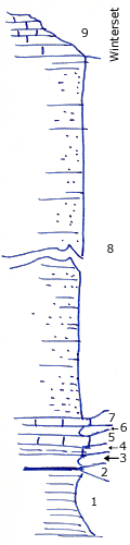
KGS Home

Geology Index Page

Montgomery County

Sec. 14, T. 34 S., R. 16 E
Move to another county

Unit No. Description Thickness
9 Winterset limestone ? ft.
8 Sandstone and sandy shale, fairly well exposed 91 ft.
7 Limestone, dark brown like exposed 1/2 mile South 0.2 - 0.4 ft.
6 Shale, gray fossiliferous 0.5 ft.
5 Limestone, like No. 7 0.2 - 0.5 ft.
4 Shale, very calcareous, full of fossil fragments, weathers gray 0.6 ft.
3 Shale, bluish gray, blocky, clay 0.85 ft.
2 Coal, with yellow, powdery shale 0.1 - 0. ft.
1 Shale, gray, clay, blocky, plant fossils in upper 2 feet 6 ft.

Original Document

The Archive file you download contains a TIFF image compressed into a ZIP archive. Your browser may be already set up to decompress these files. Commercial software to perform this is available from PKWARE, Inc., the company that invented the format. A web page from a group of people creating shareware or public domain software is available at Info-ZIP. The TIFFs are 150-dpi archival-quality color scans of the original forms and can be viewed by software like Corel PhotoPaint or Adobe PhotoShop.


Kansas Geological Survey
Comments to webadmin@kgs.ku.edu
URL=http://www.kgs.ku.edu/General/Geology/Measured/index.html
Programs Updated May 2003