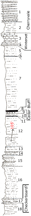
| Unit No. |
Description |
Thickness |
|
1
|
Dense blue flaggy limestone and interbedded shale
|
10 ft.
|
|
2
|
Limy gray shale
|
5 ft.
|
|
3
|
Shaly - light gray, crinoidal limestone with phosphatic nodules
|
6 ft.
|
|
4
|
Very sandy limestone or sandstone, "wormy"
|
0.5 ft.
|
|
5
|
Sandy shale and sandstone
|
5 ft.
|
|
6
|
Coal
|
0.1 ft.
|
|
7
|
Thin-bedded sandstone and sandy shale (Dodds Cr.)
|
25 ft.
|
|
8
|
Coal, Cedar Bluff (Galesburg)
|
0.9 ft.
|
|
9
|
Underclay
|
0.4 ft.
|
|
10
|
Shale
|
1.5 ft.
|
|
11
|
Coal
|
0.2 ft.
|
|
12
|
Sandy shale and fine sandstone, more silty below
|
105 ft.
|
|
13
|
Limonite layers in shale
|
3 ft.
|
|
14
|
Limestone - brown, 2 beds, thin shale between
|
1.5 ft.
|
|
15
|
Platy, micaceous sandstone, makes bench
|
5 ft.
|
|
16
|
Shale, sandy
|
15 ft.
|
|
17
|
Nodular shale and limestone, fine molluscan fauna of the Oklahoma facies crinoidal
|
2 ft.
|
|
18
|
Dark bluish clay shale
|
10 ft.
|