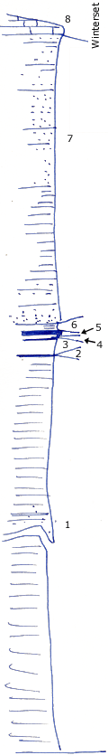
Old brick plant quarry NW Coffeyville, Kansas.
Measured By J.M. Jewett, 6/1932
|

|
|
|
| Unit No. |
Description |
Thickness |
|
8
|
Limestone - characteristic facies of Winterset limestone as seen between Independence and Coffeyville, many crinoid stems and brachiopods
|
2 - 3 ft.
|
|
7
|
Sandstone and sandy shale
|
36 ft.
|
|
6
|
Clay
|
0.7 ft.
|
|
5
|
Coal (clay shale below 3")
|
0.4 - 0.5 ft.
|
|
4
|
Coal
|
0.1 ft.
|
|
3
|
Clay, shale
|
3 ft.
|
|
2
|
Coal
|
0.1 ft.
|
|
1
|
Nearly all unit is clay shale, little sandstone 60 - 65' from base
|
100 ft.
|
|
Original Document
The Archive file you download contains a TIFF image compressed into a ZIP archive.
Your browser may be already set up to decompress these files.
Commercial software to perform this is available from
PKWARE, Inc., the company that invented the format.
A web page from a group of people creating shareware or public
domain software is available at Info-ZIP.
The TIFFs are 150-dpi archival-quality color scans of the original forms and can be viewed by software like Corel PhotoPaint or Adobe PhotoShop.
|
