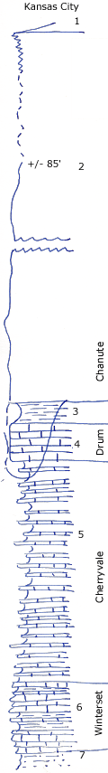
KGS Home

Geology Index Page

Montgomery County

Sec. 9, T. 34 S., R. 16 E
Move to another county

Measured By Newell, 8/1935
 
Unit No. Description Thickness
1 Thick shale with Thayer coal at top  
2 Sandstone, upper half platy and sahly, poorly shown, lower 40' massive, cross bedded, soft 85 ft.
3 Gray laminated clay shale 3 ft.
4 Thin bedded drab oolitic with Euphemites & little else 5.5 ft.
5 Flaggy blue, fine to dense silty limestone, delicately laminated, interbedded with silty gray shale limestone beds up to 0.3, shale up to 2 feet 30 ft.
6 Irregular, thin-bedded, gray crinoidal limestone with several breaks of limy shale up to 1 foot 9.5 ft.
7 Sandy shale (Galesburg)  
  Drum appears to be channeled out in a few scores of feet  

Original Document

The Archive file you download contains a TIFF image compressed into a ZIP archive. Your browser may be already set up to decompress these files. Commercial software to perform this is available from PKWARE, Inc., the company that invented the format. A web page from a group of people creating shareware or public domain software is available at Info-ZIP. The TIFFs are 150-dpi archival-quality color scans of the original forms and can be viewed by software like Corel PhotoPaint or Adobe PhotoShop.


Kansas Geological Survey
Comments to webadmin@kgs.ku.edu
URL=http://www.kgs.ku.edu/General/Geology/Measured/index.html
Programs Updated May 2003