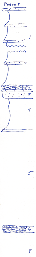
KGS Home

Geology Index Page

Montgomery County

Sec. 17, T. 35 S., R. 14 E
Move to another county

Outlier SE of Caney
Measured By Newell, 8/1935
Unit No. Description Thickness
1 Blue clay shale with limonite concretions, 3 or 4 block sandstone beds + 85 ft.
2 Conglomeratic cross bedded oolite +/- 2 ft.
3 Blocky brown sandstone 1 or 2 feet +/- 2 ft.
4 Covered 10 ft.
5 Platy oolitic limestone with Worthenia, and shale +/- 30 ft.
6 Cross bedded granular crinoidal limestone +/- 3 ft.
7 Sandy shale and sandstone 35 ft.
  Limestone mapped as Stanton not seen  

Original Document

The Archive file you download contains a TIFF image compressed into a ZIP archive. Your browser may be already set up to decompress these files. Commercial software to perform this is available from PKWARE, Inc., the company that invented the format. A web page from a group of people creating shareware or public domain software is available at Info-ZIP. The TIFFs are 150-dpi archival-quality color scans of the original forms and can be viewed by software like Corel PhotoPaint or Adobe PhotoShop.


Kansas Geological Survey
Comments to webadmin@kgs.ku.edu
URL=http://www.kgs.ku.edu/General/Geology/Measured/index.html
Programs Updated May 2003