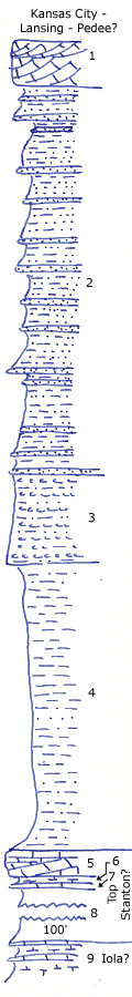
| Unit No. |
Description |
Thickness |
|
1
|
Purplish, cross bedded limestone oolite, sandy, crinoidal, with bryozoa and shell fragments
|
+/- 5 ft.
|
|
2
|
Shaly sandstone and thin-bedded irregular soft and hard sandstone beds, friable fro the most part, no fossils
|
40 ft.
|
|
3
|
Calcareous sandstone pellets or nodules in sandy gray shale, makes bench
|
10 ft.
|
|
4
|
Gray wilty and sandy shale
|
30 ft.
|
|
5
|
Shaly sandy limestone, very crinoidal
|
3 ft.
|
|
6
|
Limy shale with crinoid stems
|
1 ft.
|
|
7
|
Lenticular coarse crinoidal limestone
|
+/- 0.4 ft.
|
|
8
|
Bluish to gray silty and clayey shale with limonite concretions, lower half covered
|
+/- 100 ft.
|
|
9
|
Brownish limestone and calcareous shale with large Heliospongia, algal coated fossils at base
|
+/- 3 ft.
|