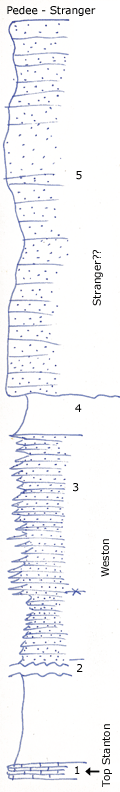
KGS Home

Geology Index Page

Montgomery County

Sec. 11, T. 35 S., R. 14 E
Move to another county

Measured By Newell, 10/1934
 
Unit No. Description Thickness
5 Massive, cross bedded, red and buff sandstone, makes scarp and long dip slope 45 - 50 ft.
4 Bluish sandy shale with evidence of channeling at top 5 ft.
3 Platy calcareous sandstone 30 - 40 ft.
2 Covered sandy shale +/- 45 ft.
1 Slabby, bluish, granular limestone, mapped as Stanton +/- 2 ft.

Original Document

The Archive file you download contains a TIFF image compressed into a ZIP archive. Your browser may be already set up to decompress these files. Commercial software to perform this is available from PKWARE, Inc., the company that invented the format. A web page from a group of people creating shareware or public domain software is available at Info-ZIP. The TIFFs are 150-dpi archival-quality color scans of the original forms and can be viewed by software like Corel PhotoPaint or Adobe PhotoShop.


Kansas Geological Survey
Comments to webadmin@kgs.ku.edu
URL=http://www.kgs.ku.edu/General/Geology/Measured/index.html
Programs Updated May 2003