|
| Unit No. |
Description |
Thickness |
|
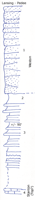
1
|
Reddish brown, heavy cross bedded sandstone with plant fossils, clay balls at base
|
+/- 40 ft.
|
|
2
|
Blue silty shale with concretionary limestone bed at middle
|
5 ft.
|
|
3
|
Sandstone and sandy shale, fine, buff, not blocky, but irregular, in thin layers, mostly covered
|
+/- 90 ft.
|
|
4
|
Stanton limestone
|
|
|

