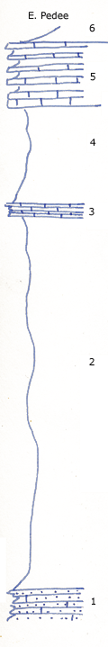
High hill just SE of Caney
Measured By Newell, 10/1934
High hill SE of Caney. The Stanton in this region is at least 300 feet thick.
|
|
|
|
| Unit No. |
Description |
Thickness |
|
6
|
Shale up to blocky sandstone capping outliers
|
|
|
5
|
Thin bedded, oolitic molluscan limestone, lower layer containing a lot of large worn Worthenioid gastropods
|
+/- 6.5 ft.
|
|
4
|
Limy shale
|
+/- 10 ft.
|
|
3
|
Crinoidal and coquinoid platy limestone with fossiliferous shale at base; Myalina subquadrata, Composita, Neospirifer, crinoid stems
|
+/- 1 ft.
|
|
2
|
Covered sandy shale
|
40 ft.
|
|
1
|
Calcareous sandstone mapped as Stanton limestone
|
|
|
Original Document
The Archive file you download contains a TIFF image compressed into a ZIP archive.
Your browser may be already set up to decompress these files.
Commercial software to perform this is available from
PKWARE, Inc., the company that invented the format.
A web page from a group of people creating shareware or public
domain software is available at Info-ZIP.
The TIFFs are 150-dpi archival-quality color scans of the original forms and can be viewed by software like Corel PhotoPaint or Adobe PhotoShop.
|
