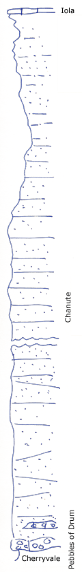
Highway West of Coffeyville
Measured By Newell, 10/1934
Measured by propecting clip estimated at 30' per mill. Description of outcrops spans section 1 and section 23.
|
|
|
|
| Unit No. |
Description |
Thickness |
|
|
Massive buff sandstone with limestone cg at base, grading through shaly beds in upper half to sandy shale
|
+/- 160 ft.
|
|
Original Document
The Archive file you download contains a TIFF image compressed into a ZIP archive.
Your browser may be already set up to decompress these files.
Commercial software to perform this is available from
PKWARE, Inc., the company that invented the format.
A web page from a group of people creating shareware or public
domain software is available at Info-ZIP.
The TIFFs are 150-dpi archival-quality color scans of the original forms and can be viewed by software like Corel PhotoPaint or Adobe PhotoShop.
|
