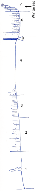
KGS Home

Geology Index Page

Montgomery County

Sec. 3, T. 35 S., R. 16 E
Move to another county

Measured By J.M. Jewett, 6/1932
Unit No. Description Thickness
7 Limestone, hard, crystalline, crinoids, and other fossils  
6 Sandstone, lower 3 feet is more massive 12.8 ft.
5 Coal 0.5 ft.
4 Nearly all units is clay shale, only slightly sandy, some sandstone and sandy shale at base 26 ft.
3 Shale mostly 10.8 ft.
2 Sandstone and sandy shale 17.1 ft.
1 Covered interval to flood plain of Onion Creek 37.8 ft.

Original Document

The Archive file you download contains a TIFF image compressed into a ZIP archive. Your browser may be already set up to decompress these files. Commercial software to perform this is available from PKWARE, Inc., the company that invented the format. A web page from a group of people creating shareware or public domain software is available at Info-ZIP. The TIFFs are 150-dpi archival-quality color scans of the original forms and can be viewed by software like Corel PhotoPaint or Adobe PhotoShop.


Kansas Geological Survey
Comments to webadmin@kgs.ku.edu
URL=http://www.kgs.ku.edu/General/Geology/Measured/index.html
Programs Updated May 2003