|
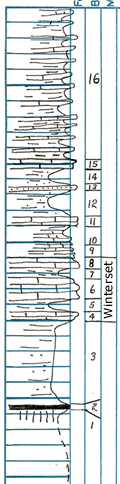
| Unit No. |
Description |
Thickness |
|
16
|
Blue flags and shale
|
20 ft.
|
|
15
|
Limestone, blue, flaggy
|
0.07 ft.
|
|
14
|
Shale, sandy
|
2.5 ft.
|
|
13
|
Sandstone, one bed
|
0.4 ft.
|
|
12
|
Sandstone and sandy shale
|
4 ft.
|
|
11
|
Limestone, blue, with white fossils
|
0.8 ft.
|
|
10
|
Shale, very fossiliferous
|
1.5 ft.
|
|
9
|
Mostly limestone, some shale, shaly at base
|
4 ft.
|
|
8
|
Limestone, yellow
|
1 ft.
|
|
7
|
Shale, fossiliferous
|
1.2 ft.
|
|
6
|
Limestone, blue to brown, sandy, upper part is harder and more crystalline
|
3.85 ft.
|
|
5
|
Shale, thin beds, many crinoid stems
|
1.5 ft.
|
|
4
|
Limestone, blue, sandy, weathers brown
|
0.2 ft.
|
|
3
|
Sandstone, thin beds, varied appearing little carbonaceous matter
|
11.8 ft.
|
|
2
|
Coal
|
0.3 ft.
|
|
1
|
Underclay, gray
|
? ft.
|
|
|
Covered slope
|
|
|

