|
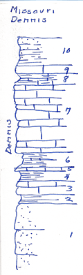
| Unit No. |
Description |
Thickness |
|
10
|
Shale light yellowish tan, very sandy, sandstone at top
|
+ 5 ft.
|
|
9
|
Limestone, blue, hard, dense, very fine, flaggy
|
1.2 ft.
|
|
8
|
Shale, bluish gray, calcareous grading to shaly granular limestone, fossiliferous, especially bryozoan, Marginifera, crinoid fragments
|
|
|
7
|
Limestone, bluish granular, irregular beds 0.2 - 0.5 thick Marginifera most abundant
|
11.5 ft.
|
|
6
|
Shale & thin limestone bluish Marginifera, Chonetes vernevilianus
|
2.7 ft.
|
|
5
|
Limestone, blue hard, Marginifera
|
0.5 ft.
|
|
4
|
Shale, blue, calcareous, Marginifera
|
2 ft.
|
|
3
|
Limestone, blue, hard, medium grained, xln fossils
|
2.1 ft.
|
|
2
|
Shale, blue, sandy - thin coal/streak (observed 1934)
|
1.6 ft.
|
|
1
|
Sandstone, bluish gray, massive exposed
|
11.1 ft.
|
|
