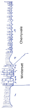
KGS Home

Geology Index Page

Montgomery County

Sec. 2, T. 35 S., R. 16 E
Move to another county

Measured By J.M. Jewett, 6/22/1932
 
Unit No. Description Thickness
9 Alternating layers of hard, dense, blue, limestone and clay shale +/- 25 ft.
8 Shale, small amount of sandstone 5.4 ft.
7 Limestone, blue, hard, many white fragments of fossils 0.5 ft.
6 Shale +/- 1 ft.
5 Limestone, dark blue, unevenly bedded, few shale partings 4 ft.
4 Shale, yellow, clay +/- 1 ft.
3 Limestone, dark blue, crystalline 0.5 ft.
2 Limestone, sandy, crinoid stems 2.9 ft.
1 Sandy shale and sandstone, mostly thin beds of sandstone 10.8 ft.

Original Document

The Archive file you download contains a TIFF image compressed into a ZIP archive. Your browser may be already set up to decompress these files. Commercial software to perform this is available from PKWARE, Inc., the company that invented the format. A web page from a group of people creating shareware or public domain software is available at Info-ZIP. The TIFFs are 150-dpi archival-quality color scans of the original forms and can be viewed by software like Corel PhotoPaint or Adobe PhotoShop.


Kansas Geological Survey
Comments to webadmin@kgs.ku.edu
URL=http://www.kgs.ku.edu/General/Geology/Measured/index.html
Programs Updated May 2003