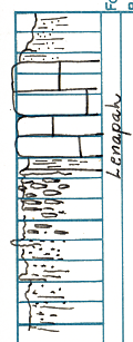
KGS Home

Geology Index Page

Montgomery County

Sec. 7, T. 35 S., R. 17 E
Move to another county

Southwest 1/4
Measured By R.G. Moore
Unit No. Description Thickness
5 Shale, brownish, sandy, poorly exposed 5 ft.
4 Limestone, bluish, weathers gray and brown, somewhat sandy, very massive, hard, contains pebbles of light bluish gray very fine, dense, algal(?) limestone, crinoid stems, Mesolobus, Prismopora and other fossils 9 ft.
3 Shale, gray, clayey, contains numerous Marginifera 1.5 ft.
2 Limestone, bluish gray, fine-grained, dense, nodular, interbedded with calcareous shale 6.5 ft.
1 Sandstone and shale, bluish gray, weathers brownish; above river level 33 ft.
  Description entries taken from Kansas Geological Society Annual Field Conference Guide, 1937 page 54  

Original Document

The Archive file you download contains a TIFF image compressed into a ZIP archive. Your browser may be already set up to decompress these files. Commercial software to perform this is available from PKWARE, Inc., the company that invented the format. A web page from a group of people creating shareware or public domain software is available at Info-ZIP. The TIFFs are 150-dpi archival-quality color scans of the original forms and can be viewed by software like Corel PhotoPaint or Adobe PhotoShop.


Kansas Geological Survey
Comments to webadmin@kgs.ku.edu
URL=http://www.kgs.ku.edu/General/Geology/Measured/index.html
Programs Updated May 2003