| Unit No. |
Description |
Thickness |
|
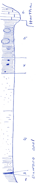
6
|
Hertha limestone - as elsewhere near by
|
3 - 4 ft.
|
|
5
|
Shale; black - with yellow, limonitic layers huge concretions
|
12.4 ft.
|
|
4
|
Shale, partly black; mostly gray small concretions
|
|
|
3
|
Sandstone and little shale. Somewhat to rather carboniferous; many plant fossils in lower part - shale at base
|
33.2 ft.
|
|
2
|
Coal with coalified logs 0.85 feet across, flattened to 0.2 - 0.3 feet
|
|
|
1
|
Shale - somewhat like underclay
|
2 - 3 ft.
|
|
|
Note: base is not far above Lenapah limestone
|
|