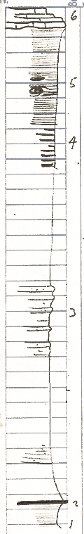
Measured By J.M. Jewett, 6/28/1935
|

|
|
|
| Unit No. |
Description |
Thickness |
|
6
|
Hertha limestone
|
3 - 4 ft.
|
|
5
|
Black - platy shale as below Hertha at Hertha large concretions, yellow limonitic layers
|
12.4 ft.
|
|
4
|
Shale black and gray
|
5.4 ft.
|
|
3
|
Shale and sandstone: sandstone in thin beds. Shale somewhat carbonaceous; abundance of plant fossils
|
43 ft.
|
|
2
|
Coal with coalified logs - logs are 0.85 feet wide flattened to 0.2 - 0.3 feet thick
|
0.3 - 0.4 ft.
|
|
1
|
Shale, somewhat like underclay
|
2 - 3 ft.
|
|
Original Document
The Archive file you download contains a TIFF image compressed into a ZIP archive.
Your browser may be already set up to decompress these files.
Commercial software to perform this is available from
PKWARE, Inc., the company that invented the format.
A web page from a group of people creating shareware or public
domain software is available at Info-ZIP.
The TIFFs are 150-dpi archival-quality color scans of the original forms and can be viewed by software like Corel PhotoPaint or Adobe PhotoShop.
|