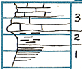
South edge of Parsons near bridge near city park
Measured By J.M. Jewett, 1939
|

|
|

|
| Unit No. |
Description |
Thickness |
|
3
|
Limestone - gray; irregular beds; reather crystalline; large fusulinids; has appearance of upper Altamont at Mound Valley
|
|
|
2
|
Shale - gray
|
1.7 ft.
|
|
1
|
Shale - black; phosphatic nodules in debris
|
1 ft.
|
|
|
Note: Top of this section is in larger creek. Base is in small ravine entering from North and on West side of street. Rather string dip to West, so top may be 10 feet or more above base, that is, may be greater thickness of Hardman limestone.
|
|
|
|
This section as well as section in WPA quarry south of Hardman quarry shows "Hardman" limestone to be upper Altamont
|
|
|
Original Document
The Archive file you download contains a TIFF image compressed into a ZIP archive.
Your browser may be already set up to decompress these files.
Commercial software to perform this is available from
PKWARE, Inc., the company that invented the format.
A web page from a group of people creating shareware or public
domain software is available at Info-ZIP.
The TIFFs are 150-dpi archival-quality color scans of the original forms and can be viewed by software like Corel PhotoPaint or Adobe PhotoShop.
|


