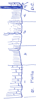
KGS Home

Geology Index Page

Labette County

Sec. 24, T. 32 S., R. 17 E
Move to another county

Measured By J.M. Jewett, 6/13/1932
Unit No. Description Thickness
6 Sandstone, Cedar Bluff sandstone thin bedded flaggy, very micaceous, weathers brown slightly cross bedded 1.5 ft.
5 Coal +/- 1 ft.
4 Mostly shale, slightly sandy, clay just below coal, a little sandstone in interval 5.4 ft.
3 Nearly all sandstone, some sandy shale fine, micaceous and yellow 27 ft.
2 Mostly shale, argillaceous, a little is sandy gray 6.2 ft.
1 Limestone, B. Falls, not well exposed +/- 11 ft.

Original Document

The Archive file you download contains a TIFF image compressed into a ZIP archive. Your browser may be already set up to decompress these files. Commercial software to perform this is available from PKWARE, Inc., the company that invented the format. A web page from a group of people creating shareware or public domain software is available at Info-ZIP. The TIFFs are 150-dpi archival-quality color scans of the original forms and can be viewed by software like Corel PhotoPaint or Adobe PhotoShop.


Kansas Geological Survey
Comments to webadmin@kgs.ku.edu
URL=http://www.kgs.ku.edu/General/Geology/Measured/index.html
Programs Updated May 2003