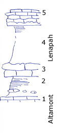
| Unit No. |
Description |
Thickness |
|
5
|
Limestone - Upper Lenapah, as at Idenbco or Angolt - nodular light color; slightly crystalline crop along road West of bridge (Lower water bridge) Slum prevents accurate measurement, Brachiopods
|
|
|
4
|
More or less covered some gray clay shale seen in upper part
|
10 - 15 ft.
|
|
3
|
Limestone dove gray Dictyoclosters abundant massive (to South it becomes reef of hummocky granular limestone, as seen just North of bridge)
|
3 ft.
|
|
2
|
Shale - mostly black and platy (nodules of black material) Concretionary dara limestone in lower part
|
+/- 5 ft.
|
|
1
|
Limestone - dark granular crystalline upper Altamont in creek
|
|
|
|
Note: This fits in with section 1/2 mile South in creek under highway bridge
|
|
|
|
No. 3 here (massive under bridge) becomes near road is slabby and hummocky a calcareous reef of plant fragments
|
|
|
|
Note: No. 5 is bed from which measurements in NW Mound Valley were taken up to Bourbon sandstone, etc. This gives Mound Valley section up and including Warrensburg sandstone
|
|