On into 18-32-19E
Measured By J.M. Jewett
|

|
|
|
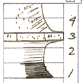
| Unit No. |
Description |
Thickness |
|
4
|
Soil
|
|
|
3
|
Sandstone has appearance of limestone probably sandstone and sand limestone of nearby sections
|
+/- 1 ft.
|
|
2
|
Shale - gray - blocky - limonitic concretions
|
3 ft.
|
|
1
|
Shale - black - seen up stream in 18-32-19E, may not be next below #2 above - with escaping gas
|
1 ft.
|
|
Original Document
The Archive file you download contains a TIFF image compressed into a ZIP archive.
Your browser may be already set up to decompress these files.
Commercial software to perform this is available from
PKWARE, Inc., the company that invented the format.
A web page from a group of people creating shareware or public
domain software is available at Info-ZIP.
The TIFFs are 150-dpi archival-quality color scans of the original forms and can be viewed by software like Corel PhotoPaint or Adobe PhotoShop.
|