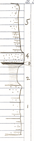
Measured By J.M. Jewett, 6-1935
|

|
|
|
| Unit No. |
Description |
Thickness |
|
5
|
Sandstone; partly massive; partly thin beds
|
15.9 ft.
|
|
4
|
Sandstone; massive
|
3 ft.
|
|
3
|
Coal
|
0.3 ft.
|
|
2
|
Clay and shale - oxidized zone below coal 0.1 ft. - no underclay
|
6 ft.
|
|
1
|
Sandstone and sandy shale - lower part mostly covered
|
+/- 14 ft.
|
|
|
Note: Base of section is about top of B. Falls limestone
|
|
|
Original Document
The Archive file you download contains a TIFF image compressed into a ZIP archive.
Your browser may be already set up to decompress these files.
Commercial software to perform this is available from
PKWARE, Inc., the company that invented the format.
A web page from a group of people creating shareware or public
domain software is available at Info-ZIP.
The TIFFs are 150-dpi archival-quality color scans of the original forms and can be viewed by software like Corel PhotoPaint or Adobe PhotoShop.
|