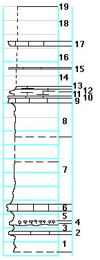
|
| Unit No. |
Description |
Thickness |
|
|
Upper Hughes Creek shale member
|
|
|
19
|
Fossil wood, a heavy log
|
-- ft.
|
|
18
|
Covered
|
5 ft.
|
|
17
|
Limestone, tough, gray, with fusulinids, Composita on the top
|
0.9 ft.
|
|
16
|
Covered
|
3 ft.
|
|
15
|
Limestone, with Bellerophon projecting into the shale above on the top
|
0.1 ft.
|
|
|
Lower Hughes Creek shale member
|
|
|
14
|
Covered
|
2.5 ft.
|
|
13
|
Shale, calcareous, with Rhipidomella carbonaria
|
0.3 ft.
|
|
12
|
Shale, calcareous, with fusulinids
|
0.3 ft.
|
|
11
|
Shale, calcareous
|
0.6 ft.
|
|
10
|
Limestone, with Linoproductus on top
|
0.2 ft.
|
|
9
|
Limestone, with Pinna, Myalina, Allorisma, nautiloids; also Derbyia at the base
|
0.8 ft.
|
|
8
|
Shale, gray, fossiliferous, Rhipidomella at base
|
5 ft.
|
|
7
|
Shale
|
9.5 ft.
|
|
|
Americus limestone member
|
|
|
6
|
Limestone, tough
|
1 ft.
|
|
5
|
Shale
|
1.5 ft.
|
|
4
|
Limestone, algal
|
0.2 ft.
|
|
3
|
Shale, gray, splittery
|
1.3 ft.
|
|
2
|
Limestone, light-gray, tough, no fossils
|
0.4 ft.
|
|
1
|
Shale, clayey, yellowish
|
2.5+ ft.
|
|

