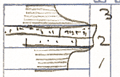
KGS Home

Geology Index Page

Labette County

Sec. 17, T. 32 S., R. 19 E
Move to another county

Measured By J.M. Jewett
Unit No. Description Thickness
3 Shale, gray - fragment of coal - fossil wood 1 - 2 ft.
2 Limestone - sandstone at top - with "worm casts" hard sandy limestone below +/- 2 ft.
1 Shale; bluish gray - fossiliferous  
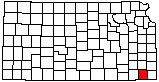
  Note: This bed crops out as sandstone ledge 1/2 mile West of Wilsonton, and 1 1/2 miles West of Wilsonton. It is sandy limestone of quarry in Mound Valley and is facies of basal Missouri sandstone mapped across state  

Original Document

The Archive file you download contains a TIFF image compressed into a ZIP archive. Your browser may be already set up to decompress these files. Commercial software to perform this is available from PKWARE, Inc., the company that invented the format. A web page from a group of people creating shareware or public domain software is available at Info-ZIP. The TIFFs are 150-dpi archival-quality color scans of the original forms and can be viewed by software like Corel PhotoPaint or Adobe PhotoShop.


Kansas Geological Survey
Comments to webadmin@kgs.ku.edu
URL=http://www.kgs.ku.edu/General/Geology/Measured/index.html
Programs Updated May 2003