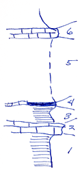
KGS Home

Geology Index Page

Labette County

Sec. 18, T. 32 S., R. 19 E
Move to another county

Measured By J.M. Jewett, 6-30-1935
Unit No. Description Thickness
6 Crinoidal limestone  
5 Covered interval 9.8 ft.
4 Coal and coalified logs, logs 5 feet long and 1 foot wide 0.5 ft.
3 Shale; gray not well seen near middle of section 18 but well seen below coal near middle of North side of section  
2 Limestone  
1 Shale; yellow and gray Sguamularia; spirifers and crinoids 4 ft.
  Starts near mid section top is in section North of North side base is West of section along East side - Where much black shale is seen also much gray shale 1/2 mile to Southeast  
  This shows crinoided limestone and sandy limestone (near Mound Valley is below Hertha limestone)  

Original Document

The Archive file you download contains a TIFF image compressed into a ZIP archive. Your browser may be already set up to decompress these files. Commercial software to perform this is available from PKWARE, Inc., the company that invented the format. A web page from a group of people creating shareware or public domain software is available at Info-ZIP. The TIFFs are 150-dpi archival-quality color scans of the original forms and can be viewed by software like Corel PhotoPaint or Adobe PhotoShop.


Kansas Geological Survey
Comments to webadmin@kgs.ku.edu
URL=http://www.kgs.ku.edu/General/Geology/Measured/index.html
Programs Updated May 2003