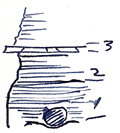
KGS Home

Geology Index Page

Labette County

Sec. 19, T. 33 S., R. 18 E
Move to another county

Measured By J.M. Jewett, 1940
Unit No. Description Thickness
3 Limestone, earthy, brown, irregular posture 0.4 - 0.5 ft.
2 Shale mostly gray some black 3 ft.
1 Shale, black, blocky to fissile 3 ft.
  Somewhat more of the black shale (1) was seen in July 1941 and concretions as elsewhere below Hertha were noted  
  This limestone (Hertha) was once called "Uniontown"  
  Large Cephlapod collected here in 1931  
  Definitely below the B. Falls and above  
  And much more black shale was seen (#1 and below) 2 miles North in 1940  

Original Document

The Archive file you download contains a TIFF image compressed into a ZIP archive. Your browser may be already set up to decompress these files. Commercial software to perform this is available from PKWARE, Inc., the company that invented the format. A web page from a group of people creating shareware or public domain software is available at Info-ZIP. The TIFFs are 150-dpi archival-quality color scans of the original forms and can be viewed by software like Corel PhotoPaint or Adobe PhotoShop.


Kansas Geological Survey
Comments to webadmin@kgs.ku.edu
URL=http://www.kgs.ku.edu/General/Geology/Measured/index.html
Programs Updated May 2003