KGS Home

Geology Index Page

Labette County

Sec. 11, T. 33 S., R. 18 E
Move to another county

South of Mound Valley
Measured By J.M. Jewett, 7-23-1941
Unit No. Description Thickness
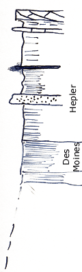
  Checkerboard limestone - cross bedded - Molluscan 2 ft.
  Shale 1 ft.
  Limestone - Checkerboard - Molluscan +/- 0.3 ft.
  Shale, gray-yellow limonitic grades into unit below 5.4 ft.
  Shale, near black, fissile, Mesolobus, gastropods, and crinoid stems 5.4 ft.
  Shale, dark, fissile 2 ft.
  Shale, dark "Trachypoan" 0.5 ft.
  Note: M.C. Oakes agrees that there is little or no doubt that this is checkerboard at top  
  No coal line below Hepler - but Dawson is present below Hepler short distance to North and Southwest  
  Disconformity may be little lower than the base of the Hepler  

Original Document

The Archive file you download contains a TIFF image compressed into a ZIP archive. Your browser may be already set up to decompress these files. Commercial software to perform this is available from PKWARE, Inc., the company that invented the format. A web page from a group of people creating shareware or public domain software is available at Info-ZIP. The TIFFs are 150-dpi archival-quality color scans of the original forms and can be viewed by software like Corel PhotoPaint or Adobe PhotoShop.


Kansas Geological Survey
Comments to webadmin@kgs.ku.edu
URL=http://www.kgs.ku.edu/General/Geology/Measured/index.html
Programs Updated May 2003