|
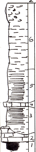
| Unit No. |
Description |
Thickness |
|
6
|
Clay and chert, both probably residual
|
+/- 3 ft.
|
|
5
|
Shale, thinly laminated dark gray to black at base; gray, weathering dun to brown above. Some thin clay ironstone zones at base
|
12 - 15 ft.
|
|
4
|
Limestone, dark gray to black. Very argillaceous. Abundant Ambocoelia and horn corals. Weathers brick red and brown
|
+/- 4 ft.
|
|
3
|
Shale, dark
|
+/- 3 ft.
|
|
2
|
Lenticular limestone, black, hard, and dense, to gray and shaly. Abundant Marginifera and crinoid fragments. This bed sometimes is conglomerate of silicified wood, nodules of limestone, etc. and contains phosphatic nodules throughout. Horn corals also are found in this zone. Also abundant Mesolobus
|
0 - 3 ft.
|
|
1
|
Coal - not seen, thickness unknown
|
|
|
|
Note: Check with stripping just northeast of this location and also with section on north side of Oswego
|
|
|