| Unit No. |
Description |
Thickness |
|
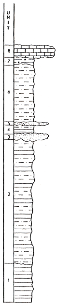
8
|
Limestone; wackestone-packstone; grains appear to be mostly crinoidal debris; basal contact sharp
|
1 m.
|
|
7
|
Clayshale; black, with phosphate nodules; fissile; base not exposed
|
0.5 m.
|
|
6
|
Siltshale; with scattered thin, ripple-laminated beds; sharp basal contact
|
0.6 m.
|
|
5
|
Sandstone; fine-grained; ripple-laminated; shale partings near gradational base
|
0.2 m.
|
|
4
|
Clayshale with silty beds near top; medium gray; highly fissile; abruptly gradational base
|
0.7 m.
|
|
3
|
Sandstone; fine-grained; load structure at base causes unit thickness to vary; no visible stratification; basal contact shapr, no evidence of erosion
|
0.4 m.
|
|
2
|
Interbedded siltshale and clayshale; medium gray; come plant remains on stratification planes
|
9.6 m.
|
|
1
|
Clayshale; medium gray; tan weathering; base not exposed
|
3 m.
|