|
| Unit No. |
Description |
Thickness |
|
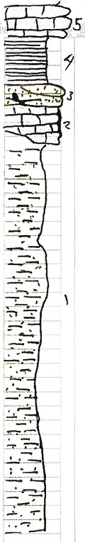
1
|
Sandy shale and thin bedded sandstone. Leached in upper 3 - 4 feet
|
+ 30 ft.
|
|
2
|
Limestone, dark gray. Mostly massive, but slabby, sandy at base. Weathers deep tan to buff. Crinoidal. Very hard.
|
24 - 30 in.
|
|
3
|
Sandstone, light gray, weathers deep brown. Medium grains.
|
6 - 15 in.
|
|
4
|
Shale, black, fissile, numerous rounded and lenticular phosphatic concretions.
|
+/- 40 ft.
|
|
5
|
Limestone, base of Ft. Scott
|
|
|