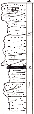
KGS Home

Geology Index Page

Labette County

Sec. 24, T. 34 S., R. 20 E
Move to another county

In creek bank
Measured By Wally Howe, 6/23/1949
Unit No. Description Thickness
3 Sandstone, cross-bedded, massive to thin-bedded. Much of it extremely calcareous, and contains Marginifera, Linoproductus, Neospirifer, Juresania + 10 ft.
2 Coal, very poor, bony. +/- 3 in.
1 Sandstone, massive to thin-bedded. Grades laterally to sandy shale. Upper part dark gray, with carbonized plant material and clay. + 8 ft.
  Associated with Stice Bevier may be below  

Original Document

The Archive file you download contains a TIFF image compressed into a ZIP archive. Your browser may be already set up to decompress these files. Commercial software to perform this is available from PKWARE, Inc., the company that invented the format. A web page from a group of people creating shareware or public domain software is available at Info-ZIP. The TIFFs are 150-dpi archival-quality color scans of the original forms and can be viewed by software like Corel PhotoPaint or Adobe PhotoShop.


Kansas Geological Survey
Comments to webadmin@kgs.ku.edu
URL=http://www.kgs.ku.edu/General/Geology/Measured/index.html
Programs Updated May 2003