|
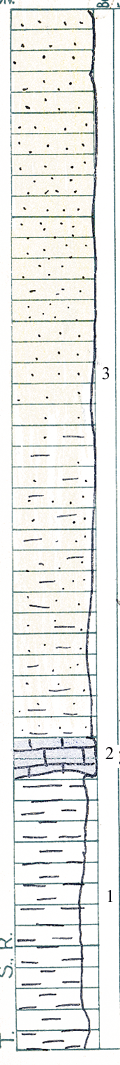
| Unit No. |
Description |
Thickness |
|
3
|
Sandstone, light gray in lower 11 feet, and very fine grained and micaceous. Thin bedded and minutely cross bedded. Upper part is thicker bedded, is light brown in color, and coarser (medium), becoming consistenly coarser toward the top.
|
+ 35 ft.
|
|
2
|
Limestone, dark gray, weathers to dun or medium brown. Forms single massive bed, but can be easily distinguished as to types. Lower part is dense, hard, weathers to rusty buff color, and is unfossiliferous. Upper part is coarse, extremely fossiliferous - cephalopods. Composita, Spirifer sp., crinoids, and break down into irregular slabs
|
20 - 24 in.
|
|
1
|
Shale, drab to dark gray, weathers to thin fragile flakes or chips. Contains quite abundant large (6 - 12 inches) clay ironstone and limonite, and or, hemotite concretions. The latter all were at one time clay ironstone. Shale is quite uniform. Base is not determined.
|
+ 37 ft.
|
|