|
| Unit No. |
Description |
Thickness |
|
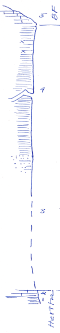
5
|
Limestone, as float blocks, light to dark gray in color, splotches of limonite, chert
|
? ft.
|
|
4
|
Shale, plant fossils in limonite near top, a great deal of limonite throughout most of unit
|
48.6 ft.
|
|
3
|
Mostly covered, sandstone, and limonitic shale near top of unit is mostly shale
|
+/- 20 ft.
|
|
2
|
Limestone, dense, hard blue, fossiliferous limestone
|
0.5 - 0.6 ft.
|
|
1
|
Shale, black with phosphatic concretions up to one inch in diameter
|
+/- 1 ft.
|
|