KGS Photo Display System

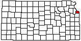
Confluence of Kansas and Missouri Rivers at Kaw Point

location map
Help Comments
County: Wyandotte Subjects: Landscapes --River
Architecture --Park
--Missouri River

photo--if missing then file not yet transferred

Photo courtesy Louis Copt/Lawrence, Kansas.
September 2004.

Kansas Geological Survey, Educational Resources
Feel free to use photos from the Kansas Geological Survey's collection for any non-commercial use.
Please credit the Kansas Geological Survey for photos you use.
Comments to webadmin@kgs.ku.edu
URL=http://www.kgs.ku.edu/Images/DB/index.html
Program updated Nov. 11, 2004. Photos added periodically.