Select location of well to view details.
Click on column heading to sort.
|
|
|
County: Allen Select location of well to view details. Click on column heading to sort. |
|
|
|
| View page: 1 || 2 || 3 || 4 || 5 || 6 || 7 || 8 || 9 || 10 || Next > | |||||||||
| T-R-S | Owner | Well Depth Ascend. Desc. |
Static Water Level Ascend. Desc. |
Est. Yield Ascend. Desc. |
Well Use | Other ID | Action Taken | Completion Date Ascend. Desc. |
Scan? |
|
T25S, R18E, Sec. 16 SE SE |
Geffert, Robert M. | 9.5 ft. | Domestic | Plugged | 09-Nov-1995 | ||||
|
T25S, R18E, Sec. 16 SW SW SW |
Riebel, Wayne | 71 ft. | 9 ft. | .5 gpm. | Domestic | Constructed | 06-Jul-1988 | ||
|
T25S, R18E, Sec. 16 SW SW SW |
Riebel, Wayne | 71 ft. | 9 ft. | .5 gpm. | Domestic | Constructed | 06-Jul-1988 | ||
|
T25S, R18E, Sec. 16 NE NE SE |
Wilson, Larry | 120 ft. | 80 ft. | Domestic | Plugged | 19-Sep-2006 | |||
|
T25S, R18E, Sec. 16 NW NE |
Wise, Allen | 27 ft. | Domestic | Plugged | 01-Jul-1996 | ||||
|
T25S, R18E, Sec. 32 SW SE NE |
Geffert, Robert M. | 28 ft. | 21 ft. | Domestic | Plugged | 02-Mar-1995 | |||
|
T25S, R18E, Sec. 34 NW NE SW NW |
Weilert, Steve | 30 ft. | 27 ft. | .25 gpm. | Domestic | Constructed | 12-Dec-2019 | ||
|
T25S, R19E, Sec. 1 SW NW NW |
Allen County Public Works | 48 ft. | Monitoring well/observation/piezometer | Constructed | 11-Sep-1997 | ||||
|
T25S, R19E, Sec. 1 NW NW NW |
Allen County Public Works | 48 ft. | Monitoring well/observation/piezometer | Constructed | 11-Sep-1997 | ||||
|
T25S, R19E, Sec. 1 NW NW NW |
Allen County Public Works | 135 ft. | 48 ft. | Monitoring well/observation/piezometer | AMW 7 M | Constructed | 10-May-1994 | ||
|
T25S, R19E, Sec. 2 SW NW NE |
Allen County Landfill | 41.5 ft. | Monitoring well/observation/piezometer | PZ 24 S | Plugged | 27-Sep-2010 | |||
|
T25S, R19E, Sec. 2 NW SW NE |
Allen County Landfill | 58.7 ft. | Monitoring well/observation/piezometer | PZ 25 M | Plugged | 27-Sep-2010 | |||
|
T25S, R19E, Sec. 2 SW NW NE |
Allen County Landfill | 60.8 ft. | Monitoring well/observation/piezometer | PZ 24 M | Plugged | 27-Sep-2010 | |||
|
T25S, R19E, Sec. 2 NW SW NE |
Allen County Landfill | 54.5 ft. | Monitoring well/observation/piezometer | MW 8 M | Plugged | 27-Sep-2010 | |||
|
T25S, R19E, Sec. 2 NE SW NE |
Allen County Landfill | 61.6 ft. | Monitoring well/observation/piezometer | PZ 20 M | Plugged | 27-Sep-2010 | |||
|
T25S, R19E, Sec. 2 NE SW NE |
Allen County Landfill | 47 ft. | Monitoring well/observation/piezometer | PZ 20 S | Plugged | 27-Sep-2010 | |||
|
T25S, R19E, Sec. 2 NW SW NE |
Allen County Landfill | 45.1 ft. | Monitoring well/observation/piezometer | MW 25 A | Plugged | 27-Sep-2010 | |||
|
T25S, R19E, Sec. 2 NW SW NE |
Allen County Landfill | 39 ft. | Monitoring well/observation/piezometer | MW 25 R | Constructed | 08-Nov-2010 | |||
|
T25S, R19E, Sec. 2 NW SW NE |
Allen County Landfill | 37 ft. | Monitoring well/observation/piezometer | MW 25 | Plugged | 27-Sep-2010 | |||
|
T25S, R19E, Sec. 2 NW SW NE |
Allen County Landfill | 48 ft. | Monitoring well/observation/piezometer | PZ 25 S | Plugged | 27-Sep-2010 | |||
|
T25S, R19E, Sec. 2 NW SW NE |
Allen County Landfill | 49 ft. | Monitoring well/observation/piezometer | MW 8 MR | Constructed | 08-Nov-2010 | |||
|
T25S, R19E, Sec. 2 |
Allen County Landfill | 32.6 ft. | Monitoring well/observation/piezometer | MW 13 | Constructed | 12-Nov-2019 |
KOLAR |
||
|
T25S, R19E, Sec. 2 N2 N2 NE NE |
Allen County Landfill | 25.4 ft. | Monitoring well/observation/piezometer | MW 11B | Constructed | 12-Nov-2019 |
KOLAR |
||
|
T25S, R19E, Sec. 2 NE NW NE |
Allen County Landfill | 35 ft. | Other
(Methane Probe) |
Constructed | 23-Aug-2024 |
KOLAR |
|||
|
T25S, R19E, Sec. 2 NW SW NE |
Allen County Landfill | 73 ft. | Monitoring well/observation/piezometer | PZ 20 MR | Constructed | 08-Nov-2010 | |||
|
T25S, R19E, Sec. 2 NE NW NE |
Allen County Landfill | 35 ft. | Other | Constructed | 23-Aug-2024 |
KOLAR |
|||
|
T25S, R19E, Sec. 2 NW NE NE |
Allen County Public Works | 38 ft. | 31.25 ft. | Monitoring well/observation/piezometer | MW 10 | Constructed | 23-Feb-1997 | ||
|
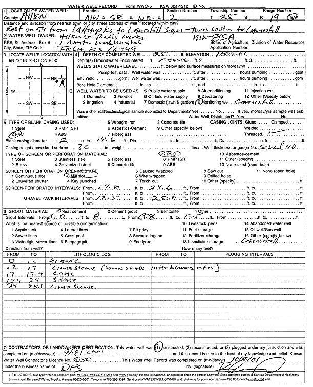
T25S, R19E, Sec. 2 NW SW NE |
Allen County Public Works | 45.45 ft. | Monitoring well/observation/piezometer | MW 25 A | Constructed | 17-Sep-2001 | |||
|
T25S, R19E, Sec. 2 NE SE NE |
Allen County Public Works | 29 ft. | 19 ft. | Monitoring well/observation/piezometer | AMW 4 S | Constructed | 10-May-1994 | ||
|
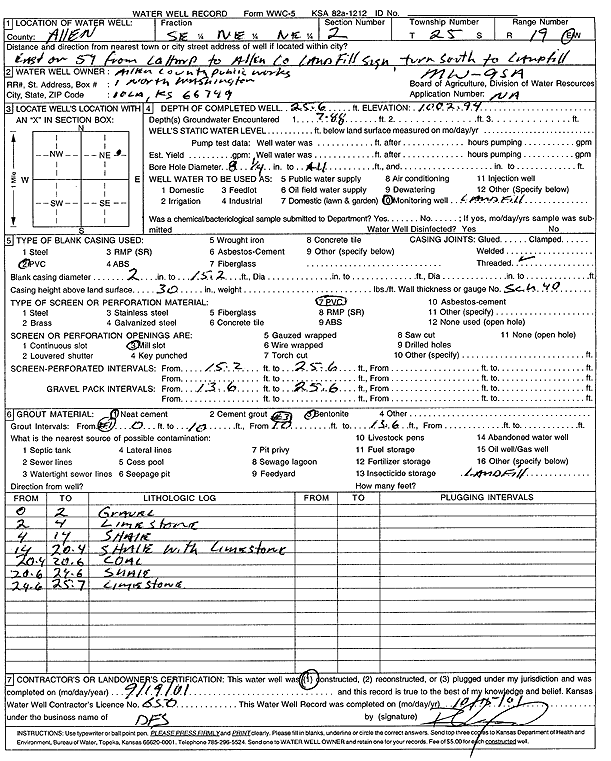
T25S, R19E, Sec. 2 SE NE NE |
Allen County Public Works | 25.6 ft. | Monitoring well/observation/piezometer | MW 9 SA | Constructed | 19-Sep-2001 | Scan | ||
|
T25S, R19E, Sec. 2 NE NW NE |
Allen County Public Works | 150 ft. | 62 ft. | Monitoring well/observation/piezometer | AMW 5 S | Constructed | 10-May-1994 | ||
|
T25S, R19E, Sec. 2 SW NE NE |
Allen County Public Works | 17 ft. | Monitoring well/observation/piezometer | AMW 1 S | Constructed | 11-May-1994 | |||
|
T25S, R19E, Sec. 2 SE NW NE |
Allen County Public Works | 135 ft. | 47 ft. | Monitoring well/observation/piezometer | AMW 6 S | Constructed | 10-May-1994 | ||
|
T25S, R19E, Sec. 2 SE SW NE |
Allen County Public Works | 62 ft. | 63 ft. | Monitoring well/observation/piezometer | AMW 3 M | Constructed | 10-May-1994 | ||
|
T25S, R19E, Sec. 2 NE NE NE |
Allen County Public Works | 37 ft. | 37 ft. | Monitoring well/observation/piezometer | PZ 2 | Plugged | 12-May-1994 | ||
|
T25S, R19E, Sec. 2 SW NE NE |
Allen County Public Works | 88 ft. | 88 ft. | Monitoring well/observation/piezometer | AMW 1 D | Constructed | 10-May-1994 | ||
|
T25S, R19E, Sec. 2 SW NE NE |
Allen County Public Works | 24 ft. | Monitoring well/observation/piezometer | PZ 4 | Plugged | 12-May-1994 | |||
|
T25S, R19E, Sec. 2 NW SE NE |
Allen County Public Works | 54.5 ft. | 24.81 ft. | Monitoring well/observation/piezometer | MW 8 | Constructed | 23-Feb-1997 | ||
|
T25S, R19E, Sec. 2 NW SE NE |
Allen County Public Works | 25 ft. | Monitoring well/observation/piezometer | MW 8 SA | Constructed | 08-Sep-2001 | Scan | ||
|
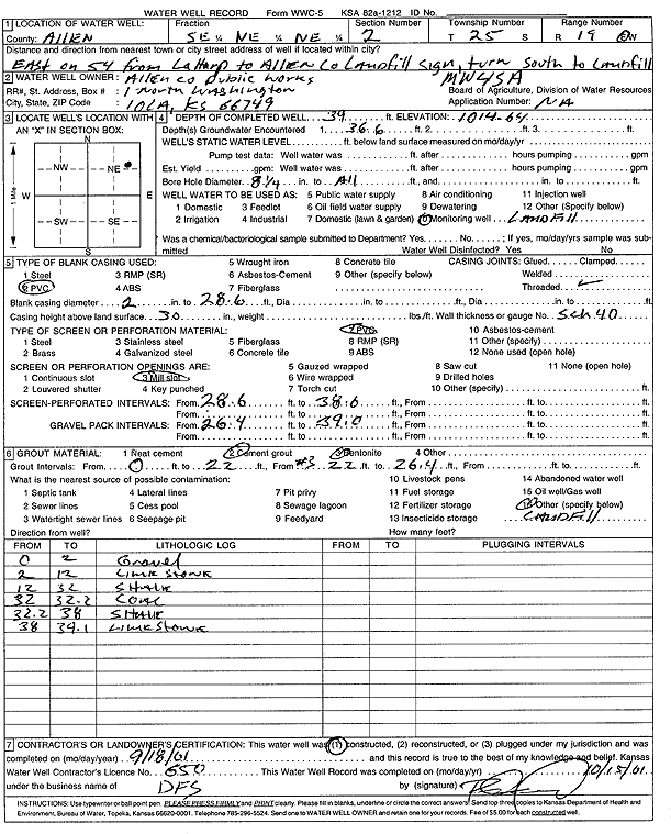
T25S, R19E, Sec. 2 SE NE NE |
Allen County Public Works | 39 ft. | Monitoring well/observation/piezometer | MW 4 SA | Constructed | 18-Sep-2001 | Scan | ||
|
T25S, R19E, Sec. 2 NW SE NE |
Allen County Public Works | 37 ft. | 37 ft. | Monitoring well/observation/piezometer | AMW 2 S | Constructed | 10-May-1994 | ||
|
T25S, R19E, Sec. 2 NE NE NE |
Allen County Public Works | 32 ft. | 32 ft. | Monitoring well/observation/piezometer | PZ 1 | Plugged | 12-May-1994 | ||
|
T25S, R19E, Sec. 2 SE NE NE |
Allen County Public Works | 33.5 ft. | 33.5 ft. | Monitoring well/observation/piezometer | PZ 3 | Plugged | 12-May-1994 | ||
|
T25S, R19E, Sec. 2 NE SE NE |
Allen County Public Works | 101 ft. | 88 ft. | Monitoring well/observation/piezometer | AMW 4 D | Constructed | 10-May-1994 | ||
|
T25S, R19E, Sec. 2 SW NE NE |
Allen County Public Works | 36 ft. | 5.95 ft. | Monitoring well/observation/piezometer | MW 9 | Constructed | 23-Feb-1997 | ||
|
T25S, R19E, Sec. 2 NE SW NE |
King, Bill | 63 ft. | Monitoring well/observation/piezometer | P 20 M | Constructed | 17-Mar-2005 | |||
|
T25S, R19E, Sec. 2 NW SW NE |
King, Bill | 62 ft. | Monitoring well/observation/piezometer | P 25 M | Constructed | 15-Mar-2005 | |||
|
T25S, R19E, Sec. 2 SW NW NE |
King, Bill | 57 ft. | Monitoring well/observation/piezometer | P 19 S | Constructed | 16-Mar-2005 | |||
|
T25S, R19E, Sec. 2 SW SW NE |
King, Bill | 64 ft. | Monitoring well/observation/piezometer | P 23 M | Constructed | 14-Oct-2005 | |||
|
T25S, R19E, Sec. 2 SW NW NE |
King, Bill | 52 ft. | Monitoring well/observation/piezometer | P 24 S | Constructed | 14-Mar-2005 | |||
| View page: 1 || 2 || 3 || 4 || 5 || 6 || 7 || 8 || 9 || 10 || Next > | |||||||||