Select location of well to view details.
Click on column heading to sort.
|
|
|
County: Leavenworth Select location of well to view details. Click on column heading to sort. |
|
|
|
| View page: < Prev || 21 || 22 || 23 || 24 || 25 || 26 || 27 || 28 || 29 || 30 || Next > | |||||||||
| T-R-S | Owner | Well Depth Ascend. Desc. |
Static Water Level Ascend. Desc. |
Est. Yield Ascend. Desc. |
Well Use | Other ID | Action Taken | Completion Date Ascend. Desc. |
Scan? |
|
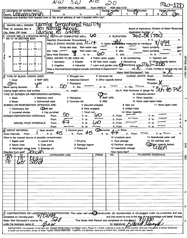
T9S, R23E, Sec. 20 NW SW NE |
Lansing Correctional Facility | 60 ft. | 12.14 ft. | Monitoring well/observation/piezometer | MW 1DD | Constructed | 27-Jul-1999 | Scan | |
|
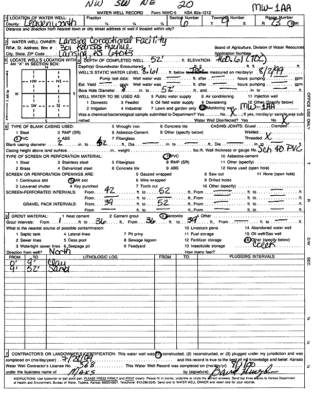
T9S, R23E, Sec. 20 NW SW NE |
Lansing Correctional Facility | 52 ft. | 8.61 ft. | Monitoring well/observation/piezometer | MW 1AA | Constructed | 28-Jul-1999 | Scan | |
|
T9S, R23E, Sec. 20 NE SE NE |
Lansing Correctional Facility | 71.9 ft. | 13.6 ft. | Other
(Potable) |
Plugged | 23-Jul-2025 |
KOLAR |
||
|
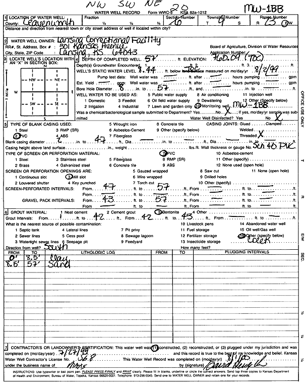
T9S, R23E, Sec. 20 NW SW NE |
Lansing Correctional Facility | 57 ft. | 8.44 ft. | Monitoring well/observation/piezometer | MW 1BB | Constructed | 27-Jul-1999 | Scan | |
|
T9S, R23E, Sec. 20 NW SW NE |
Lansing Correctional Facility | 45 ft. | 7.28 ft. | Monitoring well/observation/piezometer | MW 1N | Constructed | 28-Jul-1999 | ||
|
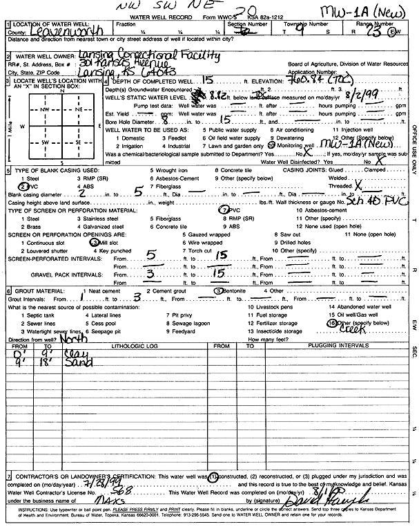
T9S, R23E, Sec. 20 NW SW NE |
Lansing Correctional Facility | 15 ft. | 8.82 ft. | Monitoring well/observation/piezometer | MW 1A | Constructed | 28-Jul-1999 | Scan | |
|
T9S, R23E, Sec. 20 SE NE NE |
Lansing Correctional Facility | 75.7 ft. | 15.5 ft. | Other
(Potable) |
Plugged | 23-Jul-2025 |
KOLAR |
||
|
T9S, R23E, Sec. 20 NW SW NE |
State of Kansas | 18 ft. | 1 ft. | Monitoring well/observation/piezometer | Well 1B | Constructed | 13-May-1993 | ||
|
T9S, R23E, Sec. 20 NW SW NE |
State of Kansas | 18 ft. | 4.5 ft. | Monitoring well/observation/piezometer | Well 1D | Constructed | 13-May-1993 | ||
|
T9S, R23E, Sec. 20 NW SW NE |
State of Kansas | 15 ft. | 1 ft. | Monitoring well/observation/piezometer | Well 1A | Constructed | 13-May-1993 | ||
|
T9S, R23E, Sec. 20 NW SW NE |
State of Kansas | 18 ft. | 4.5 ft. | Monitoring well/observation/piezometer | Well 1C | Constructed | 13-May-1993 | ||
|
T9S, R23E, Sec. 21 SW SE NW NW |
Kansas State Penitentiary | 75 ft. | 11.1 ft. | 400 gpm. | Public Water Supply | Constructed | 09-Apr-1976 | Scan | |
|
T9S, R23E, Sec. 21 SE SW NW NW |
Kansas State Penitentiary | 68 ft. | 8.2 ft. | 400 gpm. | Public Water Supply | Constructed | 14-Apr-1976 | Scan | |
|
T9S, R23E, Sec. 21 SE NW NW |
Lansing Correctional Facility | 74.6 ft. | 17.2 ft. | Other
(Potable) |
Plugged | 23-Jul-2025 |
KOLAR |
||
|
T9S, R23E, Sec. 21 SW NW NW |
Lansing Correctional Facility | 75.5 ft. | 17.9 ft. | Other
(Potable) |
Plugged | 23-Jul-2025 |
KOLAR |
||
|
T9S, R23E, Sec. 30 SW SW NE SW |
City of Leavenworth | 13.3 ft. | 6.31 ft. | Monitoring well/observation/piezometer | GW 5/MW 5 | Plugged | 11-May-2011 | ||
|
T9S, R23E, Sec. 30 NE SW SW |
City of Leavenworth | 17.1 ft. | 10 ft. | Monitoring well/observation/piezometer | MW 4 | Constructed | 30-Jun-1993 | ||
|
T9S, R23E, Sec. 30 SW NE SW |
City of Leavenworth | 17.2 ft. | 10.6 ft. | Monitoring well/observation/piezometer | MW 6A | Constructed | 10-Aug-1993 | ||
|
T9S, R23E, Sec. 30 SE SW SW |
City of Leavenworth | 18.4 ft. | 14.8 ft. | Monitoring well/observation/piezometer | MW 6 | Constructed | 30-Jun-1993 | ||
|
T9S, R23E, Sec. 30 SE NE SW |
City of Leavenworth | 21.7 ft. | 9 ft. | Monitoring well/observation/piezometer | MW 7 | Constructed | 30-Jun-1993 | ||
|
T9S, R23E, Sec. 30 SW SE SE SW |
City of Leavenworth | 516 ft. | 2.8 ft. | Monitoring well/observation/piezometer | MW-2 | Constructed | 02-May-2016 |
KOLAR |
|
|
T9S, R23E, Sec. 30 SW SE SE SW |
City of Leavenworth | 15 ft. | 1.57 ft. | Monitoring well/observation/piezometer | MW 2 | Plugged | 02-May-2016 |
KOLAR |
|
|
T9S, R23E, Sec. 30 SW SE SW |
City of Leavenworth | 13 ft. | 2 ft. | Monitoring well/observation/piezometer | MW 2 | Constructed | 10-Aug-1993 | ||
|
T9S, R23E, Sec. 30 SE NW SW |
City of Leavenworth | 13.2 ft. | Monitoring well/observation/piezometer | MW 5 | Constructed | 30-Jun-1993 | |||
|
T9S, R23E, Sec. 30 SW NE SW |
City of Leavenworth | 22 ft. | 11.25 ft. | Monitoring well/observation/piezometer | MW 8 | Constructed | 16-Aug-2004 | ||
|
T9S, R23E, Sec. 30 SW NE SW |
City of Leavenworth | 24 ft. | 13.75 ft. | Monitoring well/observation/piezometer | MW 9 | Constructed | 16-Aug-2004 | ||
|
T9S, R23E, Sec. 30 SW SE SW |
City of Leavenworth | 22 ft. | Monitoring well/observation/piezometer | MW 3 | Constructed | 29-Jun-1993 | |||
|
T9S, R23E, Sec. 30 SE SW SW |
City of Leavenworth | 18.7 ft. | Monitoring well/observation/piezometer | MW 1-A | Constructed | 15-Aug-1993 | |||
|
T9S, R23E, Sec. 30 NW SW NW |
Contemporary Industries Southern | 13.5 ft. | 5.9 ft. | Monitoring well/observation/piezometer | MW 4 | Constructed | 28-May-1997 | ||
|
T9S, R23E, Sec. 30 NW SW NW |
Contemporary Industries Southern | 14 ft. | 7.7 ft. | Monitoring well/observation/piezometer | MW 2 | Constructed | 28-May-1997 | ||
|
T9S, R23E, Sec. 30 NW SW NW |
Contemporary Industries Southern | 12 ft. | 2.7 ft. | Monitoring well/observation/piezometer | MW 1 | Constructed | 28-May-1997 | ||
|
T9S, R23E, Sec. 30 NW SW NW |
Contemporary Industries Southern | 12 ft. | 2.4 ft. | Monitoring well/observation/piezometer | MW 5 | Constructed | 28-May-1997 | ||
|
T9S, R23E, Sec. 30 NW SW NW |
Contemporary Industries Southern | 10 ft. | 9.5 ft. | Monitoring well/observation/piezometer | MW 6 | Constructed | 28-May-1997 | ||
|
T9S, R23E, Sec. 30 NW SW NW |
Contemporary Industries Southern | 13 ft. | 4.2 ft. | Monitoring well/observation/piezometer | MW 3 | Constructed | 28-May-1997 | ||
|
T9S, R23E, Sec. 30 SW NW NW NW |
KDHE (Seven Eleven #904) | 8.76 ft. | Monitoring well/observation/piezometer | MW 4 | Plugged | 09-Mar-2020 | |||
|
T9S, R23E, Sec. 30 SW NW NW NW |
KDHE (Seven Eleven #904) | 11.66 ft. | Monitoring well/observation/piezometer | MW 5 | Plugged | 09-Mar-2020 | |||
|
T9S, R23E, Sec. 30 SW NW NW NW |
KDHE (Seven Eleven #904) | 11.4 ft. | Monitoring well/observation/piezometer | MW 1 | Plugged | 09-Mar-2020 | |||
|
T9S, R23E, Sec. 30 SW NW NW NW |
KDHE (Seven Eleven #904) | 10.48 ft. | Monitoring well/observation/piezometer | MW 2 | Plugged | 09-Mar-2020 | |||
|
T9S, R23E, Sec. 32 NE NE SE |
Dodson | 100 ft. | 10 ft. | .5 gpm. | Domestic | Constructed | 13-May-1977 | ||
|
T9S, R23E, Sec. 32 NE NE SE |
Larkin Homes | 120 ft. | 20 ft. | 7 gpm. | Domestic | Constructed | 06-Sep-1977 | ||
|
T9S, R23E, Sec. 33 SW NE NE |
Lee, Richard | 60 ft. | 10 ft. | 15 gpm. | Domestic | Constructed | 22-Jun-1978 | ||
|
T9S, R23E, Sec. 33 NW SE NW |
Serwon, Paul | 80 ft. | 22 ft. | 4 gpm. | Domestic | Well 1 | Constructed | 19-Mar-1976 | |
|
T9S, R23E, Sec. 33 NW SE NW |
Serwon, Paul | 100 ft. | Test hole/well | Test 2 | Plugged | 18-Mar-1976 | |||
|
T9S, R23E, Sec. 33 NW SE NW |
Serwon, Paul | 140 ft. | 22 ft. | 1 gpm. | Domestic | Well 2 | Constructed | 19-Mar-1976 | |
|
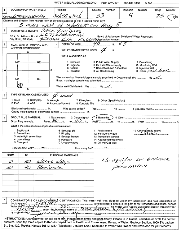
T9S, R23E, Sec. 33 SW SE SW |
Yunghans, Zane | 40 ft. | Test hole/well | Plugged | 27-Apr-2004 | ||||
|
T9S, R23E, Sec. 33 SW SE SW |
Yunghans, Zane | 40 ft. | Test hole/well | Plugged | 27-Apr-2004 | ||||
|
T9S, R23E, Sec. 33 SW SE SW |
Yunghans, Zane | 40 ft. | Test hole/well | Plugged | 27-Apr-2004 | Scan | |||
|
T9S, R23E, Sec. 34 NW NW SW |
Petty, Robert | 101 ft. | 23 ft. | 2 gpm. | Domestic | Constructed | 01-May-1977 | ||
|
T9S, R23E, Sec. 34 NW NW SW |
Petty, Robert R. | 260 ft. | (unstated)/abandoned | Plugged | 01-May-1977 | ||||
|
T10S, R20E, Sec. 1 SW SW SW |
Massbaum, W.F. | 100 ft. | 29 ft. | 2.5 gpm. | Domestic, Livestock | Constructed | 28-Feb-1973 | ||
| View page: < Prev || 21 || 22 || 23 || 24 || 25 || 26 || 27 || 28 || 29 || 30 || Next > | |||||||||