Select location of well to view details.
Click on column heading to sort.
|
|
|
County: Leavenworth Select location of well to view details. Click on column heading to sort. |
|
|
|
| View page: < Prev || 41 || 42 || 43 || 44 || 45 || 46 || 47 || 48 || 49 || 50 || Next > | |||||||||
| T-R-S | Owner | Well Depth Ascend. Desc. |
Static Water Level Ascend. Desc. |
Est. Yield Ascend. Desc. |
Well Use | Other ID | Action Taken | Completion Date Ascend. Desc. |
Scan? |
|
T12S, R21E, Sec. 1 NE NE SE |
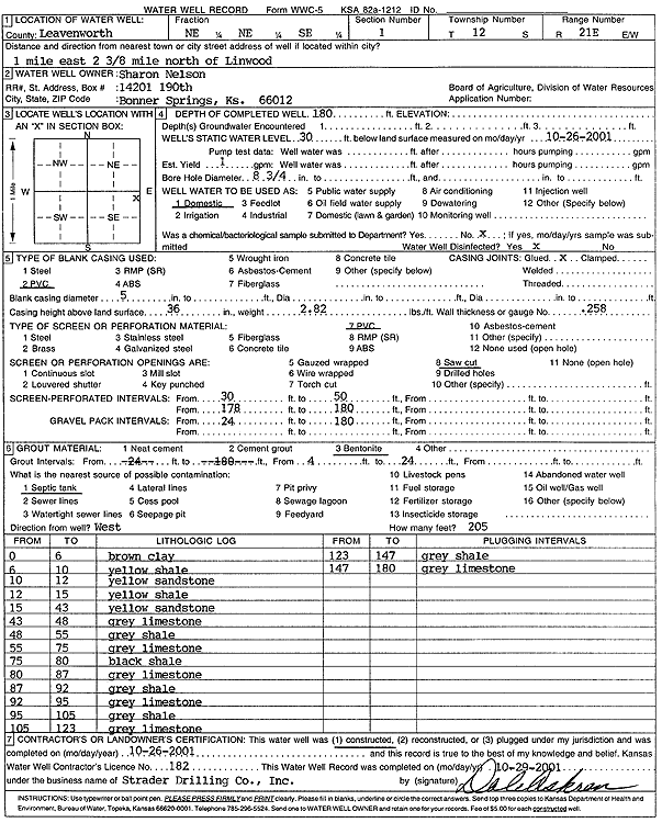
Nelson, Sharon | 180 ft. | 30 ft. | 1 gpm. | Domestic | Constructed | 26-Oct-2001 | Scan | |
|
T12S, R21E, Sec. 1 NW SE NE |
Shores, John | 140 ft. | 27 ft. | .5 gpm. | Domestic | Constructed | 08-Jan-1997 | ||
|
T12S, R21E, Sec. 1 SW SW NW SE |
Tuckel, Tomi | 105 ft. | 33 ft. | 35 gpm. | Domestic | Constructed | 29-Jan-2021 |
KOLAR |
|
|
T12S, R21E, Sec. 1 NE NE SE |
Wintermute, Mark | 240 ft. | 17 ft. | 1.5 gpm. | Domestic | Constructed | 29-Aug-1995 | ||
|
T12S, R21E, Sec. 2 SW NW NW |
Heywood, Maurice | 100 ft. | (unstated)/abandoned | Constructed | 05-Oct-1956 | ||||
|
T12S, R21E, Sec. 2 SE SE SE |
Leffert | 185 ft. | 145 ft. | (unstated)/abandoned | Constructed | 01-Jan-1956 | |||
|
T12S, R21E, Sec. 2 SW SE SE |
Leffert, Emery | 85 ft. | 32 ft. | .5 gpm. | (unstated)/abandoned | Constructed | 31-Oct-1956 | ||
|
T12S, R21E, Sec. 2 SW SE SW |
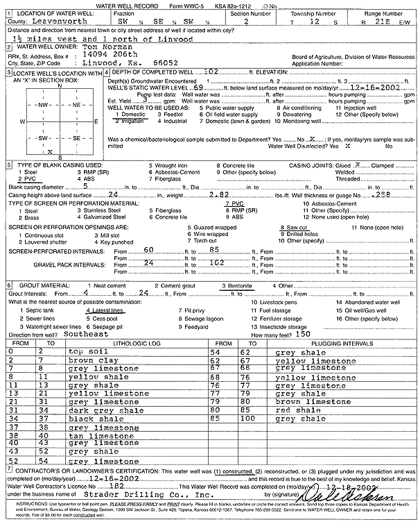
Norman, Tom | 102 ft. | 69 ft. | 3 gpm. | Domestic | Constructed | 16-Dec-2002 | Scan | |
|
T12S, R21E, Sec. 2 SE NW SE |
Pickett, Dale | 91 ft. | 30 ft. | 1.5 gpm. | Domestic | Constructed | 19-Jul-1996 | ||
|
T12S, R21E, Sec. 3 NW NW NE |
Gerlach, Jim | 100 ft. | 37 ft. | 4 gpm. | Domestic | Constructed | 11-Jul-1995 | ||
|
T12S, R21E, Sec. 3 SE SE SW |
Raider, Glen | 100 ft. | 56 ft. | .5 gpm. | Domestic | Constructed | 15-Oct-1979 | ||
|
T12S, R21E, Sec. 3 SE SW SW |
Turner, Harold | 30.6 ft. | 3.6 ft. | (unstated)/abandoned | Constructed | 25-Apr-1973 | |||
|
T12S, R21E, Sec. 4 SW SE SE |
Dodge, David | 180 ft. | Heat Pump (Closed Loop/Disposal), Geothermal | Plugged | 07-Mar-2008 | ||||
|
T12S, R21E, Sec. 4 SW |
Gilliland, John | 28 ft. | 20 ft. | (unstated)/abandoned | Plugged | 25-Apr-1973 | |||
|
T12S, R21E, Sec. 4 SE SW NE SE |
Lowen, Jesse | 200 ft. | Geothermal, Closed Loop, Vertical | Constructed | 10-Oct-2016 | ||||
|
T12S, R21E, Sec. 4 SE SW NE SE |
Lowen, Jesse | 100 ft. | 19 ft. | 8 gpm. | Domestic | Constructed | 11-Oct-2016 | ||
|
T12S, R21E, Sec. 4 NW NE SW NW |
Shilling Electric | 50 ft. | 29 ft. | 6 gpm. | Domestic, Livestock | Constructed | 04-Apr-2013 |
KOLAR |
|
|
T12S, R21E, Sec. 4 NW NW SW SW |
Shilling Electric | 90 ft. | 30 ft. | 5 gpm. | Domestic, Livestock | Constructed | 13-Apr-2013 |
KOLAR |
|
|
T12S, R21E, Sec. 4 SE SE NW |
Tailgate Ranch | 79 ft. | 30 ft. | 6 gpm. | Domestic | Constructed | 19-Jul-1988 | ||
|
T12S, R21E, Sec. 5 NE NE NE |
FDR Investors, LLC | 75 ft. | 10 ft. | 7 gpm. | Domestic | Constructed | 01-Aug-2008 | ||
|
T12S, R21E, Sec. 5 NE NE NE |
FDR Investors, LLC | 42 ft. | 7 ft. | Domestic | Constructed | 01-Aug-2008 | |||
|
T12S, R21E, Sec. 5 NW NW SW NE |
O'Hara, Patrick | 158 ft. | 61 ft. | 3 gpm. | Domestic | Constructed | 18-Feb-2016 |
KOLAR |
|
|
T12S, R21E, Sec. 6 NE NE SW |
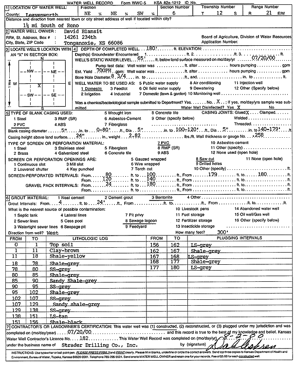
Blansit, David | 180 ft. | 65 ft. | 1.17 gpm. | Domestic | Constructed | 20-Jul-2000 | Scan | |
|
T12S, R21E, Sec. 6 SE SE SW |
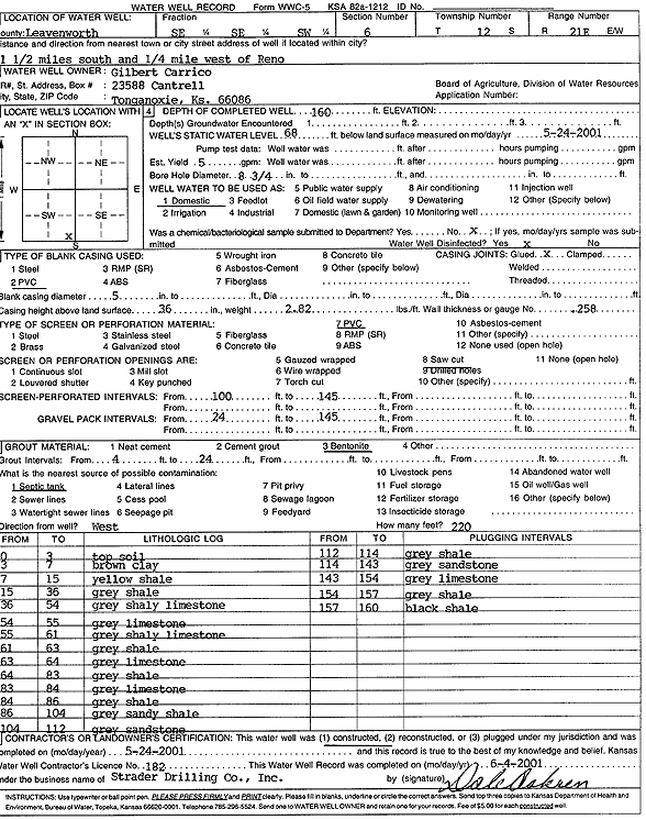
Carrico, Gilbert | 160 ft. | 68 ft. | 5 gpm. | Domestic | Constructed | 24-May-2001 | Scan | |
|
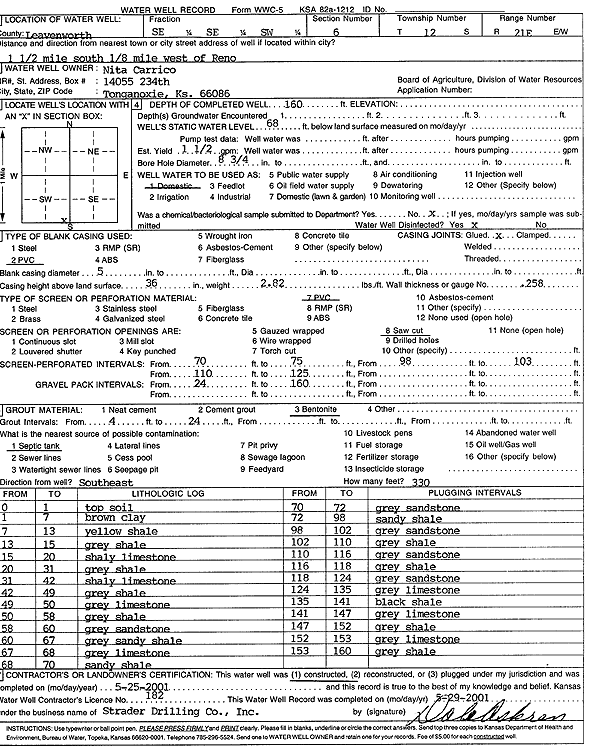
T12S, R21E, Sec. 6 SE SE SW |
Carrico, Nita | 160 ft. | 68 ft. | 1.5 gpm. | Domestic | Constructed | 25-May-2001 | Scan | |
|
T12S, R21E, Sec. 6 SW SE SW |
Leth, Kristine | 155 ft. | 87 ft. | 6 gpm. | Domestic | Constructed | 10-Oct-1991 | ||
|
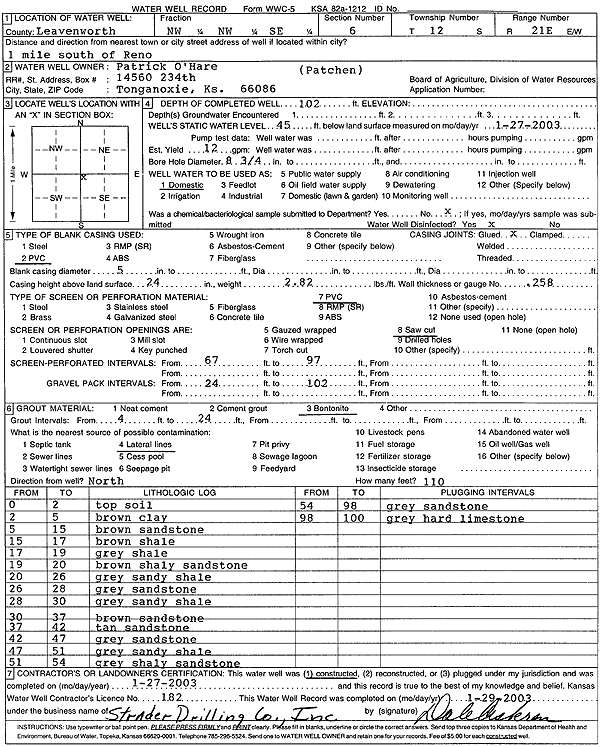
T12S, R21E, Sec. 6 NW NW SE |
O'Hare, Patrick | 102 ft. | 45 ft. | 12 gpm. | Domestic | Constructed | 27-Jan-2003 | Scan | |
|
T12S, R21E, Sec. 6 NW NW NW |
Ogden, Richard | 120 ft. | 40 ft. | 30 gpm. | Domestic | Constructed | 28-Dec-1989 | ||
|
T12S, R21E, Sec. 6 SE NW |
Ramsey, J.C. | 127 ft. | 76 ft. | 30 gpm. | (unstated)/abandoned | Well 2 | Constructed | 29-Sep-1964 | |
|
T12S, R21E, Sec. 6 SW SW NE |
Richardson, Ernie | 55 ft. | 17 ft. | 20 gpm. | Domestic | Constructed | 12-Mar-1993 | ||
|
T12S, R21E, Sec. 6 SW SE SW |
Robbins, Phillip F | 140 ft. | 77 ft. | 13 gpm. | Domestic | Constructed | 14-Dec-2006 | ||
|
T12S, R21E, Sec. 6 NW SE NW SW |
Robins, Jeremy | 144 ft. | 73 ft. | 18 gpm. | Domestic | Constructed | 01-Mar-2017 | ||
|
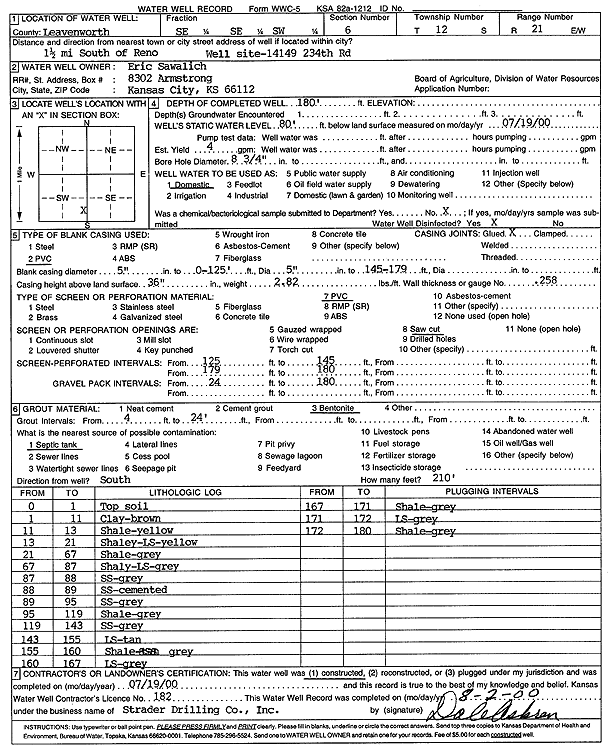
T12S, R21E, Sec. 6 SE SE SW |
Sawalich, Eric | 180 ft. | 80 ft. | 4 gpm. | Domestic | Constructed | 19-Jul-2000 | Scan | |
|
T12S, R21E, Sec. 6 NW SE NW |
Schuck, Rob | 140 ft. | 69 ft. | 20 gpm. | Domestic | Constructed | 15-Apr-2009 | ||
|
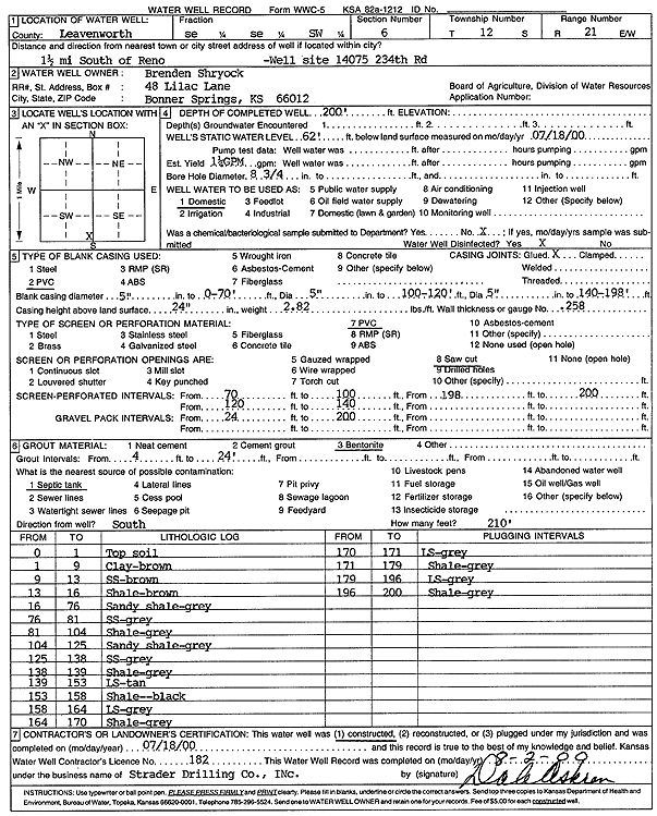
T12S, R21E, Sec. 6 SE SE SW |
Shryock, Brenden | 200 ft. | 62 ft. | 1.25 gpm. | Domestic | Constructed | 18-Jul-2000 | Scan | |
|
T12S, R21E, Sec. 6 SW NW SW |
Somers, C.L. or A. | 152 ft. | 80 ft. | 15 gpm. | Domestic | Constructed | 08-Jun-1991 | ||
|
T12S, R21E, Sec. 7 SW SW SE |
Hummelgaard, C.W. | 167 ft. | Domestic | Plugged | 08-Oct-1991 | ||||
|
T12S, R21E, Sec. 7 SW SW SE |
Hummelgaard, C.W. | 122 ft. | 65 ft. | 4.5 gpm. | Domestic | Constructed | 20-Aug-1981 | ||
|
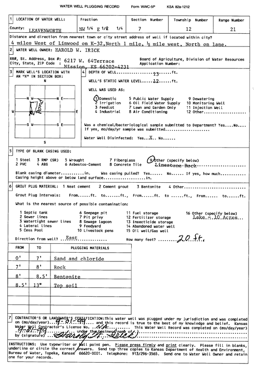
T12S, R21E, Sec. 7 NW E2 |
Irick, Harold W. | 13 ft. | 12 ft. | Domestic | Plugged | 01-Sep-1999 | Scan | ||
|
T12S, R21E, Sec. 8 NW SW NE |
Gene Owens Building Co. | 60 ft. | 2 ft. | 2 gpm. | Domestic | Constructed | 29-Aug-1991 | ||
|
T12S, R21E, Sec. 8 NW SW SW |
Greenwell, Walter | 160 ft. | 75 ft. | (unstated)/abandoned | Constructed | 23-Jun-1956 | |||
|
T12S, R21E, Sec. 8 E2 |
Keller, Jack | 172 ft. | 51 ft. | (unstated)/abandoned | Constructed | 01-Jan-1956 | |||
|
T12S, R21E, Sec. 8 SE SE NE |
Owen, Eugene P. | 80 ft. | 12 ft. | 8 gpm. | Domestic | Constructed | 16-Jul-1976 | ||
|
T12S, R21E, Sec. 8 NE NW NE SE |
Owen, Gene | 25.5 ft. | 14.5 ft. | (unstated)/abandoned | Constructed | 26-Apr-1973 | |||
|
T12S, R21E, Sec. 9 NE NW NE SW |
Bell, Jim | 57 ft. | 18 ft. | 2.5 gpm. | Irrigation | Constructed | 13-Feb-2017 | ||
|
T12S, R21E, Sec. 9 SE NE SW |
Crowe, Lloyd and Martha | 45 ft. | 19 ft. | 20 gpm. | Domestic | Constructed | 20-Nov-1991 | ||
|
T12S, R21E, Sec. 9 SE NE SE |
Gress | 170 ft. | 5 gpm. | Domestic, Livestock | Constructed | 01-Jan-1955 | |||
|
T12S, R21E, Sec. 9 NE NW SW |
Mosser, Gene | 58 ft. | 21 ft. | 8 gpm. | Domestic | Constructed | 30-Aug-1991 | ||
|
T12S, R21E, Sec. 10 NW NW NW |
Barnett, Leonard | 83 ft. | 9 ft. | 1.5 gpm. | Domestic | Constructed | 19-Jul-1978 | ||
|
T12S, R21E, Sec. 10 NE NE |
Barnett, Ray | 70 ft. | 30 ft. | 2 gpm. | Domestic | Constructed | 20-Jul-1988 | ||
| View page: < Prev || 41 || 42 || 43 || 44 || 45 || 46 || 47 || 48 || 49 || 50 || Next > | |||||||||