Select location of well to view details.
Click on column heading to sort.
|
|
|
County: Leavenworth Select location of well to view details. Click on column heading to sort. |
|
|
|
| View page: < Prev || 51 || 52 || 53 || 54 || 55 || 56 || 57 | |||||||||
| T-R-S | Owner | Well Depth Ascend. Desc. |
Static Water Level Ascend. Desc. |
Est. Yield Ascend. Desc. |
Well Use | Other ID | Action Taken | Completion Date Ascend. Desc. |
Scan? |
|
T12S, R22E, Sec. 16 NE NE NE |
Little, Brian | 130 ft. | 20 ft. | 10 gpm. | Domestic | Constructed | 17-Mar-2009 | ||
|
T12S, R22E, Sec. 17 NW SE SE |
Montgomery, Rob | 54 ft. | 13 ft. | 1 gpm. | Domestic, Lawn and Garden | Constructed | 02-Aug-2024 |
KOLAR |
|
|
T12S, R22E, Sec. 17 SW NE SE |
Montgomery, Rob | 50 ft. | 13 ft. | 10 gpm. | Domestic, Lawn and Garden | Constructed | 05-Aug-2024 |
KOLAR |
|
|
T12S, R22E, Sec. 17 SE NE SW SW |
Parr, Don | 56 ft. | 23 ft. | 50 gpm. | Domestic | Constructed | 16-Jun-2021 |
KOLAR |
|
|
T12S, R22E, Sec. 18 SE NW SW |
Mosser | 62 ft. | 28 ft. | 20 gpm. | (unstated)/abandoned | Constructed | 15-Jul-1961 | ||
|
T12S, R22E, Sec. 18 NE SE SW |
Mosser, P.G. | 54 ft. | 40 ft. | 1 gpm. | Domestic | Constructed | 16-Mar-1977 | ||
|
T12S, R22E, Sec. 18 SE NW NW |
Mosser, Percy | 60 ft. | 40 ft. | 10 gpm. | Domestic | Constructed | 06-May-1977 | ||
|
T12S, R22E, Sec. 18 NW SW SE |
Mosser, Percy | 44 ft. | 20 ft. | 15 gpm. | Domestic | Constructed | 06-May-1977 | ||
|
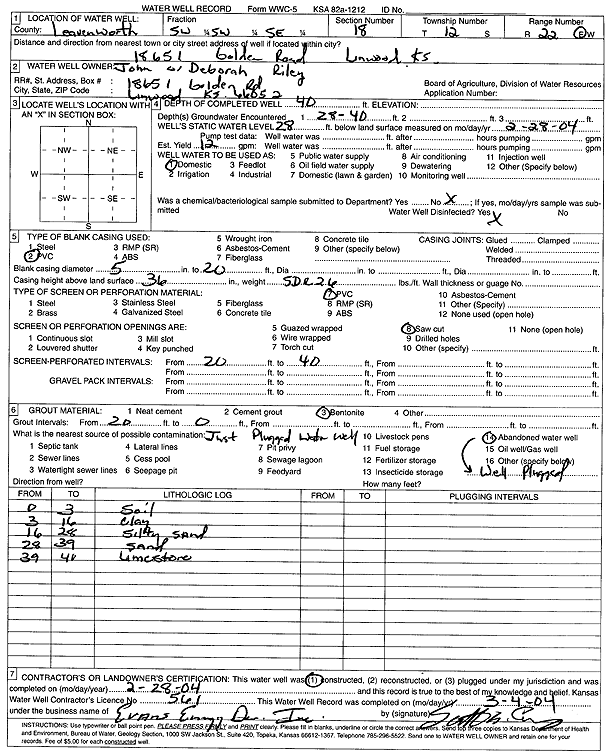
T12S, R22E, Sec. 18 SW SW SE |
Riley, John and Deborah | 40 ft. | 28 ft. | 12 gpm. | Domestic | Constructed | 28-Feb-2004 | Scan | |
|
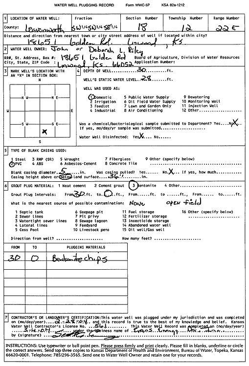
T12S, R22E, Sec. 18 SW SW SE |
Riley, John and Deborah L. | 30 ft. | 28 ft. | Domestic | Plugged | 28-Feb-2004 | Scan | ||
|
T12S, R22E, Sec. 18 SE SW NW |
Stouffer, Gilbert | 53 ft. | 12 ft. | 13 gpm. | Domestic | Constructed | 29-Nov-1994 | ||
|
T12S, R22E, Sec. 18 NW NW SW |
Thompson, Peter B. | 82 ft. | 27 ft. | 10 gpm. | Domestic | Constructed | 13-Aug-1996 | ||
|
T12S, R22E, Sec. 19 SE NE NE |
City of Olathe | 60 ft. | 22.5 ft. | Monitoring well/observation/piezometer | Site 9 W Well | Plugged | 29-Dec-2006 | ||
|
T12S, R22E, Sec. 19 SE NE NE |
City of Olathe | 60.3 ft. | 21 ft. | Test hole/well | W Well | Constructed | 23-Mar-2006 | ||
|
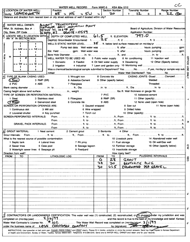
T12S, R22E, Sec. 20 NE NE SW |
Alliant Tech Systems | 61.5 ft. | 25 ft. | (unstated)/abandoned | Plugged | 10-Feb-1999 | Scan | ||
|
T12S, R22E, Sec. 20 NW NW SE |
City of Olathe | 58.3 ft. | 24 ft. | Test hole/well | E Well | Constructed | 24-Mar-2006 | ||
|
T12S, R22E, Sec. 20 NW NW SE |
City of Olathe | 56 ft. | 30 ft. | Monitoring well/observation/piezometer | Site 4 E Well | Plugged | 29-Dec-2006 | ||
|
T12S, R22E, Sec. 20 NW NW NW |
Jefferson Co. RWD 13 | 76.6 ft. | 23.2 ft. | Monitoring well/observation/piezometer | Plugged | 16-May-2025 |
KOLAR |
||
|
T12S, R22E, Sec. 20 NE NE NW |
Mosser, Percy | 34 ft. | 15 ft. | 6 gpm. | Domestic | Constructed | 06-May-1977 | ||
|
T12S, R22E, Sec. 20 SW NE NW NE |
Parr, Don | 55 ft. | 18 ft. | 25 gpm. | Domestic | Constructed | 31-Jul-2015 |
KOLAR |
|
|
T12S, R22E, Sec. 21 SW NW SE |
City of DeSoto | 64 ft. | 28 ft. | 900 gpm. | Public Water Supply | Well 19 | Constructed | 16-Sep-2024 |
KOLAR |
|
T12S, R22E, Sec. 21 SE NE SW |
City of DeSoto | 58.5 ft. | 23.6 ft. | Public Water Supply | Well 9 | Plugged | 30-Apr-2025 |
KOLAR |
|
|
T12S, R22E, Sec. 21 NE NW SW |
City of Olathe | 70 ft. | Monitoring well/observation/piezometer | TW 12 OB 1 W | Constructed | 09-Nov-2006 | |||
|
T12S, R22E, Sec. 21 N2 SW |
City of Olathe | 70 ft. | 31 ft. | Monitoring well/observation/piezometer | TW 12 OB 1 N | Plugged | 19-Mar-2007 | ||
|
T12S, R22E, Sec. 21 NE NW SW |
City of Olathe | 68 ft. | 31 ft. | Monitoring well/observation/piezometer | TW 12 OB 1 E | Plugged | 19-Mar-2007 | ||
|
T12S, R22E, Sec. 21 NE NW SW |
City of Olathe | 71 ft. | 31 ft. | Monitoring well/observation/piezometer | TW 12-06 | Plugged | 19-Mar-2007 | ||
|
T12S, R22E, Sec. 21 NE NW SW |
City of Olathe | 70 ft. | 31 ft. | Monitoring well/observation/piezometer | TW 12 OB 1 W | Plugged | 19-Mar-2007 | ||
|
T12S, R22E, Sec. 21 C S2 NW |
City of Olathe | 70 ft. | Monitoring well/observation/piezometer | TW 12 OB 2 N | Constructed | 09-Nov-2006 | |||
|
T12S, R22E, Sec. 21 NW NE SW |
City of Olathe | 68 ft. | 31 ft. | Monitoring well/observation/piezometer | OB 20-06 | Plugged | 19-Mar-2007 | ||
|
T12S, R22E, Sec. 21 C N2 SW |
City of Olathe | 70 ft. | Monitoring well/observation/piezometer | TW 12 OB 1 N | Constructed | 13-Nov-2006 | |||
|
T12S, R22E, Sec. 21 NE NW SW |
City of Olathe | 70 ft. | Monitoring well/observation/piezometer | TH 12-06 | Constructed | 21-Feb-2006 | |||
|
T12S, R22E, Sec. 21 S2 NW |
City of Olathe | 70 ft. | 31 ft. | Monitoring well/observation/piezometer | TW 12 OB 2 N | Plugged | 19-Mar-2007 | ||
|
T12S, R22E, Sec. 21 NE NW SW |
City of Olathe | 68 ft. | 31 ft. | Monitoring well/observation/piezometer | Northside TH 12-06 | Plugged | 19-Mar-2007 | ||
|
T12S, R22E, Sec. 21 NW NE SW |
City of Olathe | 70 ft. | Monitoring well/observation/piezometer | OB 20-06 | Constructed | 10-Aug-2006 | |||
|
T12S, R22E, Sec. 21 NW NW SE |
City of Olathe | 73 ft. | 31 ft. | Test hole/well | TW 12-06 | Constructed | 19-Dec-2006 | ||
|
T12S, R22E, Sec. 21 SE SW NE |
Givens, Lawrence | 52 ft. | 20 ft. | 40 gpm. | Domestic | Constructed | 19-Jul-1988 | ||
|
T12S, R22E, Sec. 21 SE NW NE |
Givens, Lawrence | 45 ft. | 20 ft. | 12 gpm. | Domestic | Constructed | 28-Dec-1978 | ||
|
T12S, R22E, Sec. 21 NW NW SE |
Oelschlager, Robert | 45 ft. | 22 ft. | 50 gpm. | Domestic | Constructed | 25-Aug-1986 | ||
|
T12S, R22E, Sec. 21 NW NW NE |
Olander, J.W. | 60 ft. | 25 ft. | 7 gpm. | Domestic | Constructed | 14-Mar-1988 | ||
|
T12S, R22E, Sec. 21 NE SE NW |
Sunflower Army Ammunition Plant | 53 ft. | 22 ft. | Monitoring well/observation/piezometer | 8-82 | Constructed | 03-Feb-1982 | ||
|
T12S, R22E, Sec. 21 NE NE SE |
Sunflower Army Ammunition Plant | 58 ft. | 24 ft. | Monitoring well/observation/piezometer | 11-82 | Constructed | 03-Feb-1982 | ||
|
T12S, R22E, Sec. 21 NE NW SW |
Tinberg Farms | 60 ft. | 26 ft. | 50 gpm. | Domestic | Constructed | 07-Jan-1997 | ||
|
T12S, R22E, Sec. 21 NW NE NW |
USGS and KGS | 72.5 ft. | Test Hole, Uncased | Constructed | 17-Apr-1952 | ||||
|
T12S, R22E, Sec. 21 NE NE NW |
Vernon, Jerry | 70 ft. | 7 ft. | 7 gpm. | Domestic | Constructed | 17-Jun-1991 | ||
|
T12S, R22E, Sec. 22 NW NW SE |
Dabbs, Helen | 50 ft. | 23 ft. | 50 gpm. | Domestic | Constructed | 27-Dec-1988 | ||
|
T12S, R22E, Sec. 22 NW NW NE |
Donaldson, Don | 150 ft. | Heat Pump (Closed Loop/Disposal), Geothermal | Constructed | 15-May-2006 | ||||
|
T12S, R22E, Sec. 22 NW NW NE |
Donaldson, Don | 150 ft. | 30 ft. | 10 gpm. | Domestic | Constructed | 15-May-2006 | ||
|
T12S, R22E, Sec. 22 NE NE NW NW |
Groundsource | 180 ft. | Geothermal, Closed Loop, Vertical | Constructed | 31-Jan-2017 |
KOLAR |
|||
|
T12S, R22E, Sec. 22 SW NW SE |
Olander, J. | 51 ft. | 24 ft. | 100 gpm. | Domestic | Constructed | 17-Aug-2007 | ||
|
T12S, R22E, Sec. 22 NE NE SW |
Olander, Jay | 50 ft. | 23 ft. | 50 gpm. | Domestic | Constructed | 15-Jun-1989 | ||
| View page: < Prev || 51 || 52 || 53 || 54 || 55 || 56 || 57 | |||||||||