Select location of well to view details.
Click on column heading to sort.
|
|
|
County: Bourbon Select location of well to view details. Click on column heading to sort. |
|
|
|
| View page: 1 || 2 || 3 || 4 || 5 || 6 | |||||||||
| T-R-S | Owner | Well Depth Ascend. Desc. |
Static Water Level Ascend. Desc. |
Est. Yield Ascend. Desc. |
Well Use | Other ID | Action Taken | Completion Date Ascend. Desc. |
Scan? |
|---|---|---|---|---|---|---|---|---|---|
|
T25S, R25E, Sec. 31 NE SE SW |
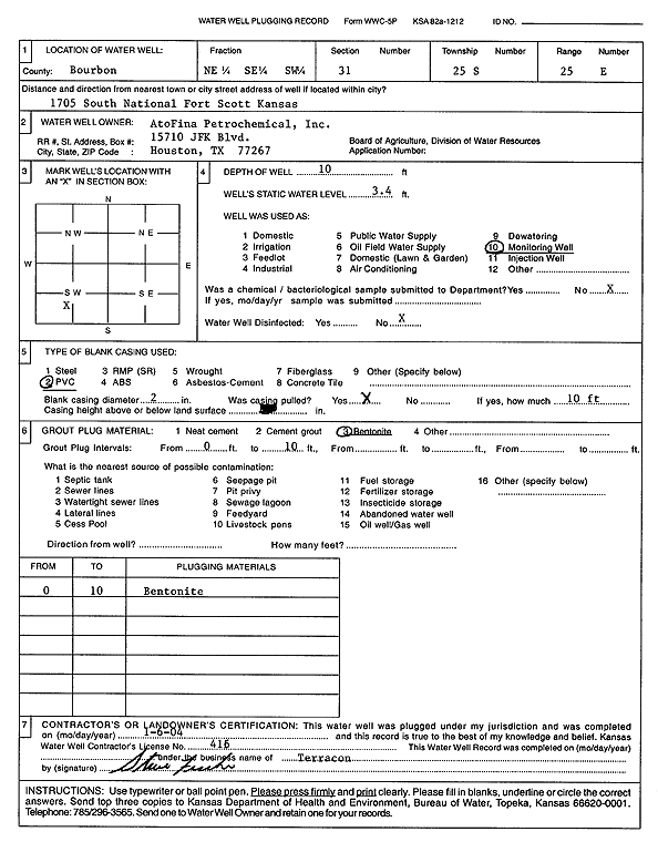
AtoFina Petrochemicals, Inc. | 10 ft. | 3.4 ft. | Monitoring well/observation/piezometer | Plugged | 06-Jan-2004 | Scan | ||
|
T25S, R25E, Sec. 31 NE SE SW |
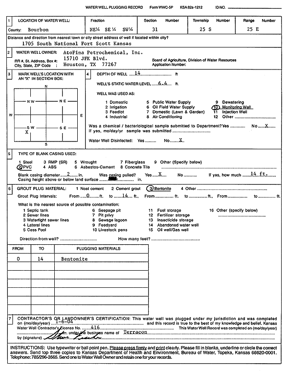
AtoFina Petrochemicals, Inc. | 14 ft. | 6.4 ft. | Monitoring well/observation/piezometer | Plugged | 06-Jan-2004 | Scan | ||
|
T25S, R25E, Sec. 31 NE SE SW |
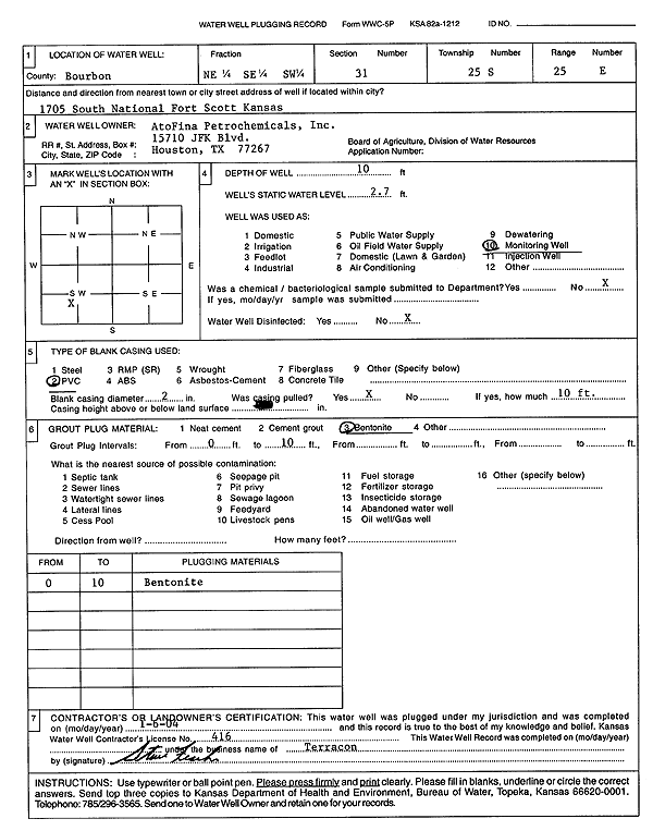
AtoFina Petrochemicals, Inc. | 10 ft. | 2.7 ft. | Monitoring well/observation/piezometer | Plugged | 06-Jan-2004 | Scan | ||
|
T25S, R25E, Sec. 31 NE SE SW |
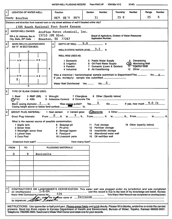
AtoFina Petrochemicals, Inc. | 9 ft. | 3.3 ft. | Monitoring well/observation/piezometer | Plugged | 06-Jan-2004 | Scan | ||
|
T27S, R25E, Sec. 1 N2 NE SE |
Bills Coal | 1010 ft. | 126 ft. | 180 gpm. | Industrial | Well 1 | Plugged | 10-Mar-1988 | |
|
T27S, R25E, Sec. 1 N2 NE SE |
Bills Coal | 918 ft. | 132 ft. | 350 gpm. | Industrial | Well 2 | Plugged | 15-Mar-1988 | |
|
T26S, R25E, Sec. 25 SE SW SW |
Bills Coal Co, Inc. | 47 ft. | Monitoring well/observation/piezometer | Constructed | 23-Sep-1981 | ||||
|
T26S, R25E, Sec. 25 SW SE SW |
Bills Coal Co, Inc. | 38 ft. | Monitoring well/observation/piezometer | Constructed | 23-Sep-1981 | ||||
|
T25S, R25E, Sec. 19 NE NE |
Bourbon County Commissioners | 10 ft. | 7.53 ft. | Monitoring well/observation/piezometer | MW 1 | Constructed | 10-Jun-2010 | ||
|
T25S, R25E, Sec. 19 SW NE |
Bourbon County Commissioners | 20 ft. | 3.81 ft. | Monitoring well/observation/piezometer | MW 2 | Constructed | 10-Jun-2010 | ||
|
T25S, R25E, Sec. 19 SE NE |
Bourbon County Commissioners | 30 ft. | 7.31 ft. | Monitoring well/observation/piezometer | MW 3 | Constructed | 10-Jun-2010 | ||
|
T25S, R25E, Sec. 30 SW NE NE SW |
BP Products North America | 19 ft. | 6.68 ft. | Monitoring well/observation/piezometer | MW 1 | Constructed | 16-Feb-2016 |
KOLAR |
|
|
T25S, R25E, Sec. 30 NW SE NE SW |
BP Products North America | 18 ft. | 8.79 ft. | Monitoring well/observation/piezometer | MW 2 | Constructed | 16-Feb-2016 |
KOLAR |
|
|
T25S, R25E, Sec. 30 SW NE NE SW |
BP Products North America | 18 ft. | 8.44 ft. | Monitoring well/observation/piezometer | MW 3 | Constructed | 16-Feb-2016 |
KOLAR |
|
|
T25S, R25E, Sec. 30 SW NE NE SW |
BP Products North America | 18 ft. | 7.21 ft. | Monitoring well/observation/piezometer | MW 4 | Constructed | 16-Feb-2016 |
KOLAR |
|
|
T25S, R25E, Sec. 30 NW SE NE SW |
BP Products North America | 18 ft. | 6.74 ft. | Monitoring well/observation/piezometer | MW 5 | Constructed | 16-Feb-2016 |
KOLAR |
|
|
T23S, R21E, Sec. 25 NW SE NE |
Bradley, Brad | 200 ft. | Geothermal, Closed Loop, Vertical | Constructed | 27-Dec-2011 | ||||
|
T23S, R21E, Sec. 25 SE SW NE NE |
Bradly, William | 190 ft. | 0 gpm. | Domestic | Plugged | 17-Sep-2011 |
KOLAR |
||
|
T26S, R25E, Sec. 31 SW SW SW |
Chambers, Harvey | 100 ft. | 18 ft. | .07 gpm. | Domestic | Constructed | 23-Aug-1978 | ||
|
T25S, R24E, Sec. 36 NE NE |
City of Fort Scott | 1350 ft. | Public Water Supply | Plugged | 17-Sep-1987 | ||||
|
T25S, R24E, Sec. 36 NE NE |
City of Fort Scott | 1400 ft. | Public Water Supply | Plugged | 11-Sep-1987 | ||||
|
T25S, R24E, Sec. 36 SE SE SE NE |
Clary, Elisa | 205 ft. | Geothermal, Closed Loop, Vertical | Constructed | 11-Jun-2015 |
KOLAR |
|||
|
T27S, R25E, Sec. 22 SE SE SW |
Clemens Coal Co. | 39 ft. | 23.65 ft. | Monitoring well/observation/piezometer | Constructed | 02-Dec-1996 | |||
|
T27S, R25E, Sec. 22 NW NW SW |
Clemens Coal Co. | 23 ft. | 10 ft. | Monitoring well/observation/piezometer | Constructed | 02-Dec-1996 | |||
|
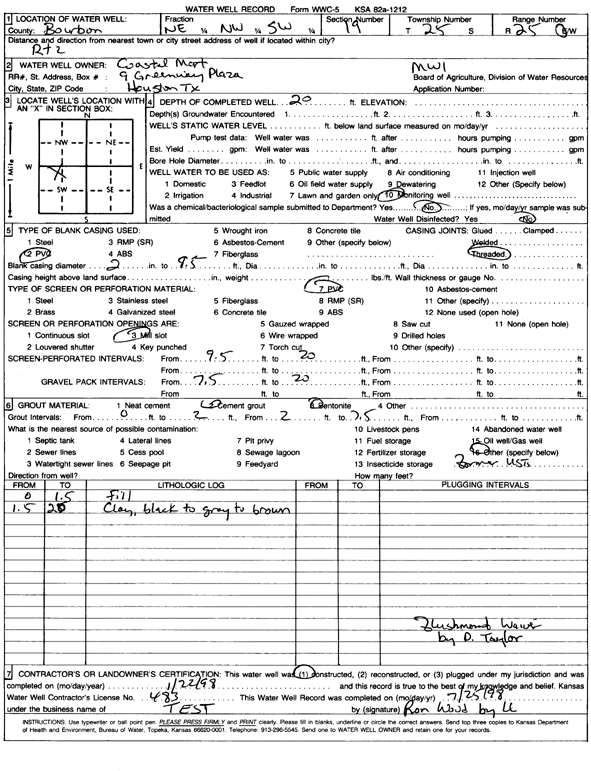
T25S, R25E, Sec. 19 NE NW SW |
Coastal Mart, Inc. | 20 ft. | Monitoring well/observation/piezometer | MW 1 | Constructed | 22-Jan-1998 | Scan | ||
|
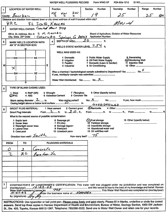
T25S, R25E, Sec. 19 NE NW SW |
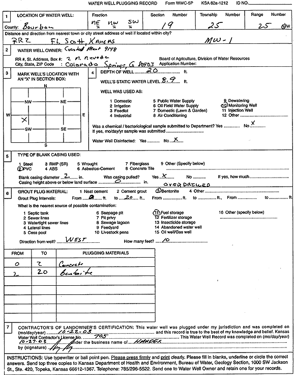
Coastal Mart, Inc. | 20 ft. | 8.9 ft. | Monitoring well/observation/piezometer | MW 1 | Plugged | 22-Oct-2003 | Scan | |
|
T25S, R25E, Sec. 19 NE NW SW |
Coastal Mart, Inc. | 20 ft. | 6.38 ft. | Monitoring well/observation/piezometer | MW 2 | Plugged | 22-Oct-2003 | Scan | |
|
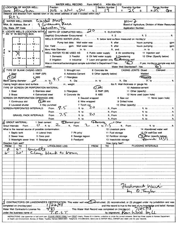
T25S, R25E, Sec. 19 NE NW SW |
Coastal Mart, Inc. | 20 ft. | Monitoring well/observation/piezometer | MW 2 | Constructed | 22-Jan-1998 | Scan | ||
|
T25S, R25E, Sec. 19 NE NW SW |
Coastal Mart, Inc. | 19.5 ft. | 7.9 ft. | Monitoring well/observation/piezometer | MW 3 | Plugged | 22-Oct-2003 | Scan | |
|
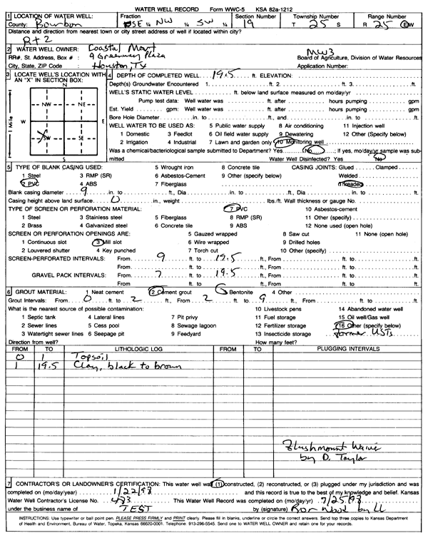
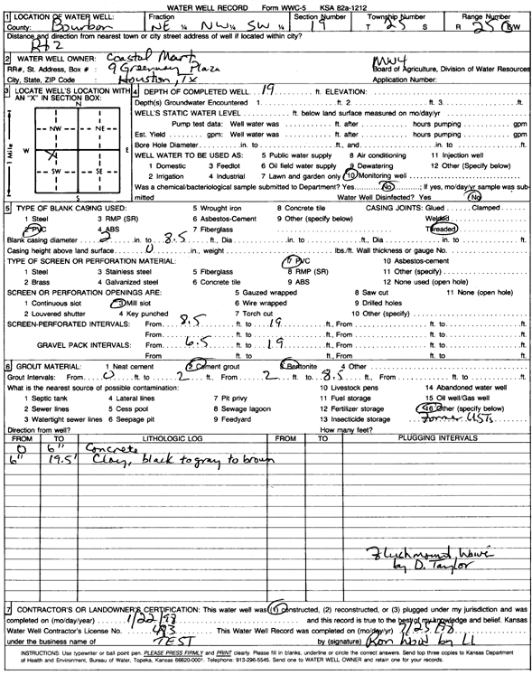
T25S, R25E, Sec. 19 SE NW SW |
Coastal Mart, Inc. | 19.5 ft. | Monitoring well/observation/piezometer | MW 3 | Constructed | 22-Jan-1998 | Scan | ||
|
T25S, R25E, Sec. 19 NE NW SW |
Coastal Mart, Inc. | 20 ft. | 7.54 ft. | Monitoring well/observation/piezometer | MW 4 | Plugged | 22-Oct-2003 | Scan | |
|
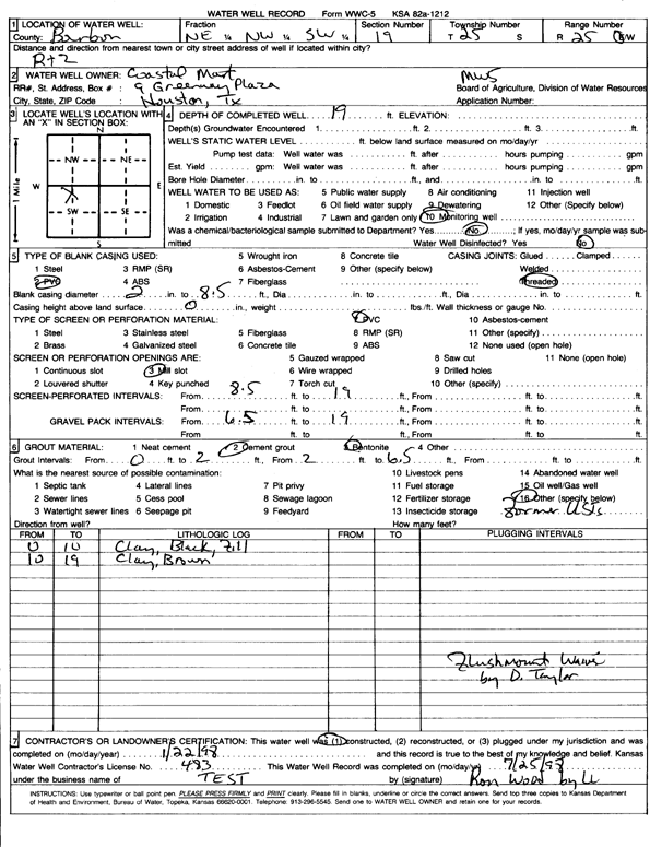
T25S, R25E, Sec. 19 NE NW SW |
Coastal Mart, Inc. | 19 ft. | Monitoring well/observation/piezometer | MW 4 | Constructed | 22-Jan-1998 | Scan | ||
|
T25S, R25E, Sec. 19 NE NW SW |
Coastal Mart, Inc. | 19 ft. | Monitoring well/observation/piezometer | MW 5 | Constructed | 22-Jan-1998 | Scan | ||
|
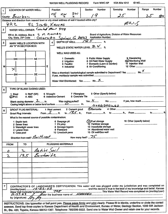
T25S, R25E, Sec. 19 NE NW SW |
Coastal Mart, Inc. | 19.5 ft. | 8.4 ft. | Monitoring well/observation/piezometer | MW 5 | Plugged | 22-Oct-2003 | Scan | |
|
T26S, R25E, Sec. 13 SE NE SE |
Continental Coal | 55 ft. | 12.5 ft. | Monitoring well/observation/piezometer | MW 4 | Plugged | 04-Nov-2011 | ||
|
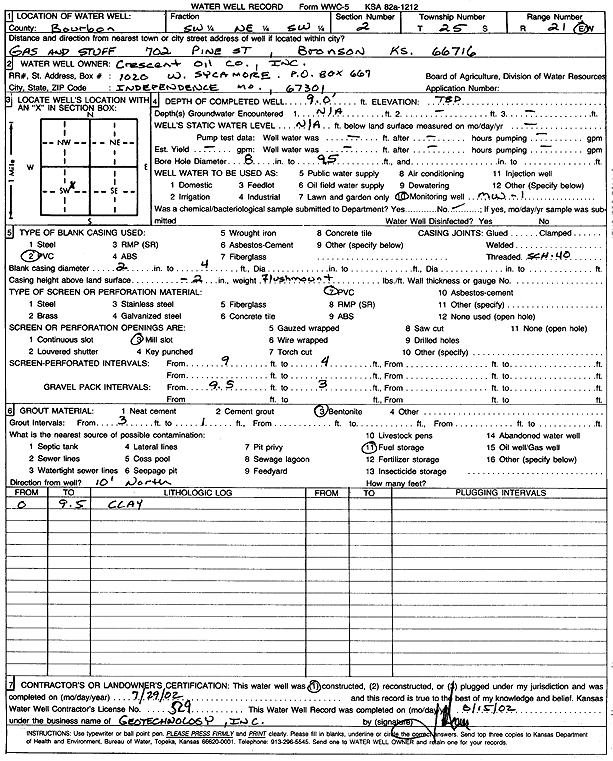
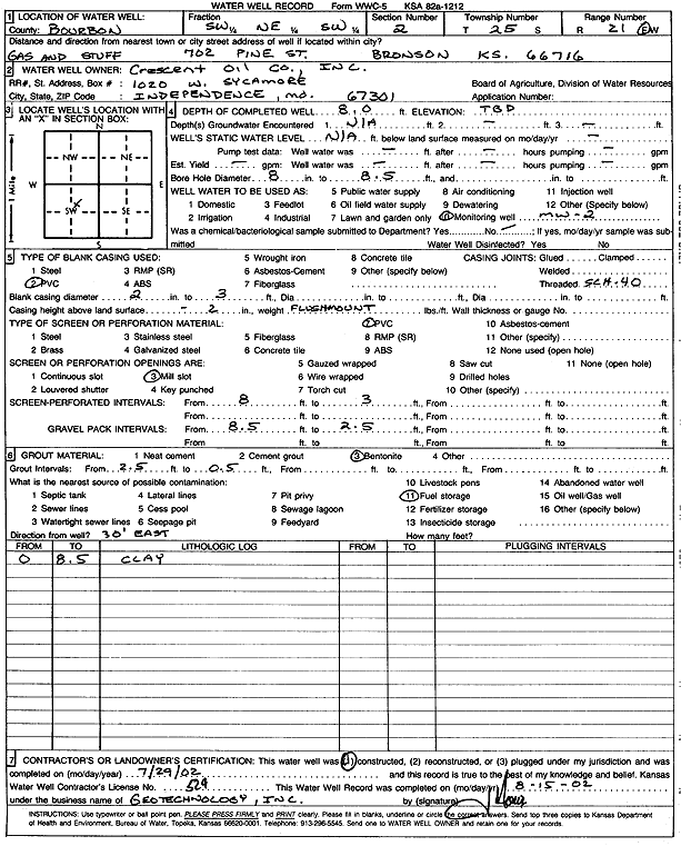
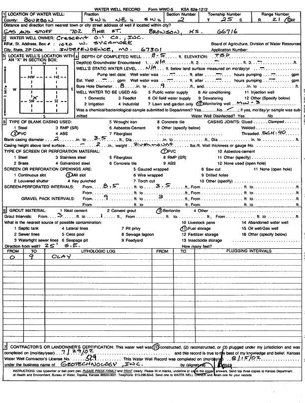
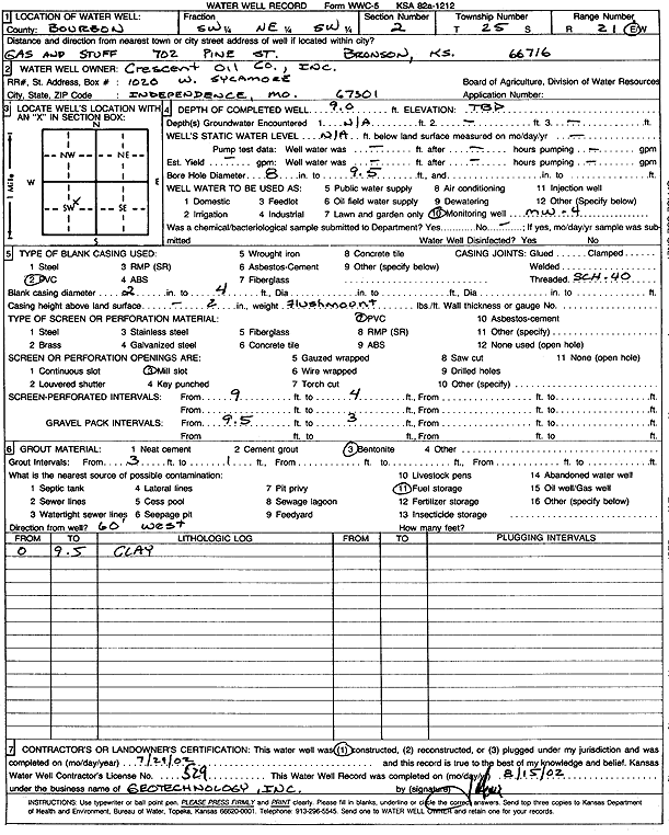
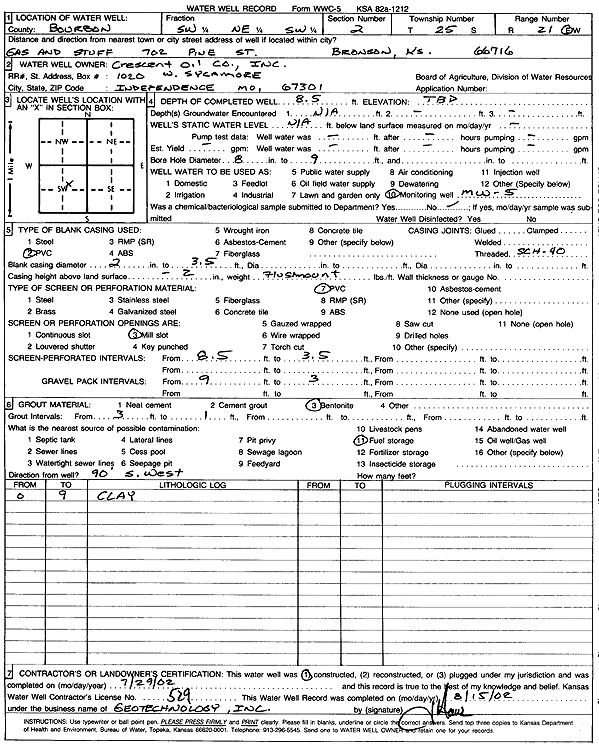
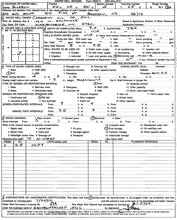
T25S, R21E, Sec. 2 SW NE SW |
Crescent Oil Co., Inc. | 9 ft. | Monitoring well/observation/piezometer | MW 1 | Constructed | 29-Jul-2002 | Scan | ||
|
T25S, R21E, Sec. 2 SW NE SW |
Crescent Oil Co., Inc. | 8 ft. | Monitoring well/observation/piezometer | MW 2 | Constructed | 29-Jul-2002 | Scan | ||
|
T25S, R21E, Sec. 2 SW NE SW |
Crescent Oil Co., Inc. | 8.5 ft. | Monitoring well/observation/piezometer | MW 3 | Constructed | 29-Jul-2002 | Scan | ||
|
T25S, R21E, Sec. 2 SW NE SW |
Crescent Oil Co., Inc. | 9 ft. | Monitoring well/observation/piezometer | MW 4 | Constructed | 29-Jul-2002 | Scan | ||
|
T25S, R21E, Sec. 2 SW NE SW |
Crescent Oil Co., Inc. | 8.5 ft. | Monitoring well/observation/piezometer | MW 5 | Constructed | 29-Jul-2002 | Scan | ||
|
T25S, R21E, Sec. 2 SW NE SW |
Crescent Oil Co., Inc. | 9 ft. | Monitoring well/observation/piezometer | MW 6 | Constructed | 29-Jul-2002 | Scan | ||
|
T25S, R24E, Sec. 2 SW NE SW |
Crescent Oil Company | 8.65 ft. | 6.65 ft. | Monitoring well/observation/piezometer | MW 1 | Plugged | 16-Oct-2007 | ||
|
T25S, R24E, Sec. 2 SW NE SW |
Crescent Oil Company | 7.8 ft. | 7.75 ft. | Monitoring well/observation/piezometer | MW 2 | Plugged | 16-Oct-2007 | ||
|
T25S, R24E, Sec. 2 SW NE SW |
Crescent Oil Company | 8.05 ft. | 6.8 ft. | Monitoring well/observation/piezometer | MW 3 | Plugged | 16-Oct-2007 | ||
|
T25S, R24E, Sec. 2 SW NE SW |
Crescent Oil Company | 8.85 ft. | 5.85 ft. | Monitoring well/observation/piezometer | MW 4 | Plugged | 16-Oct-2007 | ||
|
T25S, R24E, Sec. 2 SW NE SW |
Crescent Oil Company | 8.45 ft. | 5.8 ft. | Monitoring well/observation/piezometer | MW 5 | Plugged | 16-Oct-2007 | ||
|
T25S, R24E, Sec. 2 SW NE SW |
Crescent Oil Company | 8.75 ft. | 8.5 ft. | Monitoring well/observation/piezometer | MW 6 | Plugged | 16-Oct-2007 | ||
|
T24S, R25E, Sec. 20 SW |
Crowder, Claude | 515 ft. | Domestic | Constructed | 01-Jan-1934 | ||||
|
T26S, R25E, Sec. 13 N2 NE NW SW |
Custom Alloy Sales LF, LLC | 25.88 ft. | 11.92 ft. | Monitoring well/observation/piezometer | MW 2 | Plugged | 20-May-2021 | ||
|
T26S, R25E, Sec. 13 NE NW SW |
Custom Alloy Sales LF, LLC | 23 ft. | 9.83 ft. | Monitoring well/observation/piezometer | MW 2A | Constructed | 16-Feb-2022 |
KOLAR |
|
| View page: 1 || 2 || 3 || 4 || 5 || 6 | |||||||||