Select location of well to view details.
Click on column heading to sort.
|
|
|
County: Lyon Select location of well to view details. Click on column heading to sort. |
|
|
|
| View page: < Prev || 11 || 12 || 13 || 14 || 15 || 16 || 17 || 18 || 19 || 20 || Next > | |||||||||
| T-R-S | Owner | Well Depth Ascend. Desc. |
Static Water Level Ascend. Desc. |
Est. Yield Ascend. Desc. |
Well Use | Other ID | Action Taken | Completion Date Ascend. Desc. |
Scan? |
|
T19S, R11E, Sec. 7 SW SE NW |
Debauge Bros. Inc | 24 ft. | 18 ft. | (unstated)/abandoned | Plugged | 12-Apr-1988 | |||
|
T19S, R11E, Sec. 7 SE SE SE |
EVCO Wholesale Food Corp | 29.6 ft. | 15.6 ft. | Domestic | Plugged | 25-Nov-1994 | |||
|
T19S, R11E, Sec. 7 SW |
Flying J | 40 ft. | 18 ft. | Domestic | Plugged | 27-Feb-1998 | |||
|
T19S, R11E, Sec. 7 SW |
Flying J | 45 ft. | 19 ft. | Domestic | Plugged | 27-Feb-1998 | |||
|
T19S, R11E, Sec. 7 SE SW SW |
J.D. Miller and Sons Inc | 40 ft. | 5 ft. | 80 gpm. | Domestic | Constructed | 24-Jun-1984 | ||
|
T19S, R11E, Sec. 7 NW SE SW |
Lapping, Joe | 49 ft. | 14 ft. | 50 gpm. | Domestic | Constructed | 30-Jul-1983 | ||
|
T19S, R11E, Sec. 7 SW |
55 ft. | 19 ft. | Feedlot | Plugged | 28-Feb-1998 | ||||
|
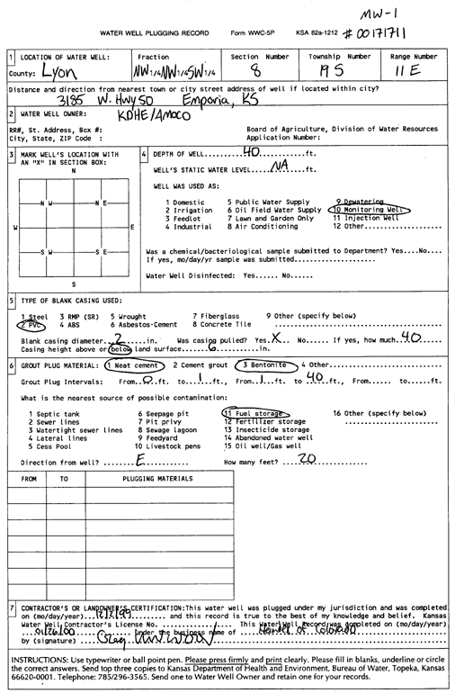
T19S, R11E, Sec. 8 NW NW SW |
Amoco Oil Co. | 40 ft. | Monitoring well/observation/piezometer | MW 1 | Constructed | 06-Dec-1991 | |||
|
T19S, R11E, Sec. 8 NW NW SW |
Amoco Oil Co. | 40 ft. | 32.77 ft. | Monitoring well/observation/piezometer | MW 3 | Constructed | 13-Jan-1992 | ||
|
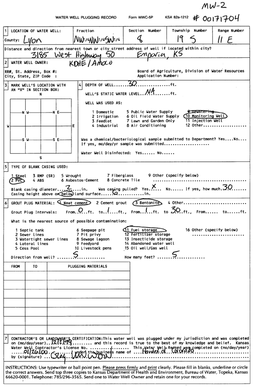
T19S, R11E, Sec. 8 NW NW SW |
Amoco Oil Co. | 40 ft. | 34 ft. | Monitoring well/observation/piezometer | MW 2 | Constructed | 06-Dec-1991 | ||
|
T19S, R11E, Sec. 8 SE SW SE |
Blue Stem Farm and Ranch Supply | Domestic | Plugged | 31-Oct-1994 | |||||
|
T19S, R11E, Sec. 8 NW SW NE SW |
Buffalo Ridge Properties | 35 ft. | 24.75 ft. | Monitoring well/observation/piezometer | MW 3 | Constructed | 09-Nov-2017 | ||
|
T19S, R11E, Sec. 8 NE SE NW SW |
Buffalo Ridge Properties | 35 ft. | 23.5 ft. | Monitoring well/observation/piezometer | MW 10 | Constructed | 16-Apr-2018 | ||
|
T19S, R11E, Sec. 8 NW SW NE SW |
Buffalo Ridge Properties | 35 ft. | 22.85 ft. | Monitoring well/observation/piezometer | MW 5 | Constructed | 14-Nov-2017 | ||
|
T19S, R11E, Sec. 8 NW SW NE SW |
Buffalo Ridge Properties | 35 ft. | 24.95 ft. | Monitoring well/observation/piezometer | MW 1 | Constructed | 14-Nov-2017 | ||
|
T19S, R11E, Sec. 8 NE SE NW SW |
Buffalo Ridge Properties | 35 ft. | 23.9 ft. | Monitoring well/observation/piezometer | MW 8 | Constructed | 13-Nov-2017 | ||
|
T19S, R11E, Sec. 8 NW SW NE SW |
Buffalo Ridge Properties | 35 ft. | 24.69 ft. | Monitoring well/observation/piezometer | MW 4 | Constructed | 13-Nov-2017 | ||
|
T19S, R11E, Sec. 8 NW SW NE SW |
Buffalo Ridge Properties | 35 ft. | 24.01 ft. | Monitoring well/observation/piezometer | MW 6 | Constructed | 08-Nov-2017 | ||
|
T19S, R11E, Sec. 8 NW SW NE SW |
Buffalo Ridge Properties | 35 ft. | 24.83 ft. | Monitoring well/observation/piezometer | MW 2 | Constructed | 09-Nov-2017 | ||
|
T19S, R11E, Sec. 8 NW SW NE SW |
Buffalo Ridge Properties | 35 ft. | 26.5 ft. | Monitoring well/observation/piezometer | MW 9 | Constructed | 16-Apr-2018 | ||
|
T19S, R11E, Sec. 8 NW SW NE SW |
Buffalo Ridge Properties | 35 ft. | 23.55 ft. | Monitoring well/observation/piezometer | MW 7 | Constructed | 14-Nov-2017 | ||
|
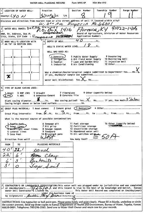
T19S, R11E, Sec. 8 SW SW |
Danner, DeEtta | 40 ft. | 18 ft. | Domestic | Plugged | 25-Jul-2001 | Scan | ||
|
T19S, R11E, Sec. 8 NW NW SW |
Emporia Oil | 44 ft. | 33.44 ft. | Monitoring well/observation/piezometer | MW 6 | Constructed | 10-Sep-1997 | ||
|
T19S, R11E, Sec. 8 NW NW SW |
Emporia Oil | 47 ft. | 33.84 ft. | Monitoring well/observation/piezometer | MW 4 | Constructed | 09-Sep-1997 | ||
|
T19S, R11E, Sec. 8 NW NW SW |
Emporia Oil | 49 ft. | 34.5 ft. | Monitoring well/observation/piezometer | MW 2 | Constructed | 08-Sep-1997 | ||
|
T19S, R11E, Sec. 8 NW NW SW |
Emporia Oil | 47 ft. | 32.78 ft. | Monitoring well/observation/piezometer | MW 8 | Constructed | 11-Sep-1997 | ||
|
T19S, R11E, Sec. 8 NW NW SW |
Emporia Oil | 47 ft. | 31.71 ft. | Monitoring well/observation/piezometer | MW 7 | Constructed | 10-Sep-1997 | ||
|
T19S, R11E, Sec. 8 NW NW SW |
Emporia Oil | 47 ft. | 32.75 ft. | Monitoring well/observation/piezometer | MW 5 | Constructed | 09-Sep-1997 | ||
|
T19S, R11E, Sec. 8 NW NW SW |
Emporia Oil | 46 ft. | 34.48 ft. | Monitoring well/observation/piezometer | MW 3 | Constructed | 09-Sep-1997 | ||
|
T19S, R11E, Sec. 8 NW NW SW |
Emporia Oil | 48 ft. | 35.51 ft. | Monitoring well/observation/piezometer | MW 11 | Constructed | 12-Sep-1997 | ||
|
T19S, R11E, Sec. 8 NW NW SW |
Emporia Oil | 20 ft. | 10.5 ft. | Monitoring well/observation/piezometer | MW 1 | Constructed | 08-Sep-1997 | ||
|
T19S, R11E, Sec. 8 NW NW SW |
Emporia Oil | 48 ft. | 31.61 ft. | Monitoring well/observation/piezometer | MW 10 | Constructed | 12-Sep-1997 | ||
|
T19S, R11E, Sec. 8 NW NW SW |
Emporia Oil | 47 ft. | 34.14 ft. | Monitoring well/observation/piezometer | MW 9 | Constructed | 12-Sep-1997 | ||
|
T19S, R11E, Sec. 8 NW NW NW |
Flint Hills Technical College | 400 ft. | 250 ft. | 3 gpm. | Heat Pump (Closed Loop/Disposal), Geothermal | Constructed | 01-Apr-2011 | ||
|
T19S, R11E, Sec. 8 NE NE SE |
Gaylord, Larrie E. | 50 ft. | 30 ft. | 40 gpm. | Domestic, Lawn and Garden | Constructed | 10-Nov-1978 | ||
|
T19S, R11E, Sec. 8 NE NW NW NE |
KDHE (Emporia Stop 2 Shop #1) | 14.5 ft. | 7.03 ft. | Monitoring well/observation/piezometer | MW 12 | Constructed | 21-Nov-2019 | ||
|
T19S, R11E, Sec. 8 NW NW SW |
KDHE/Amoco | 38 ft. | Monitoring well/observation/piezometer | MW 3 | Plugged | 02-Dec-1999 | |||
|
T19S, R11E, Sec. 8 NW NW SW |
KDHE/Amoco | 40 ft. | Monitoring well/observation/piezometer | MW 1 | Plugged | 02-Dec-1999 | Scan | ||
|
T19S, R11E, Sec. 8 NW NW SW |
KDHE/Amoco | 30 ft. | Monitoring well/observation/piezometer | MW 2 | Plugged | 02-Dec-1999 | Scan | ||
|
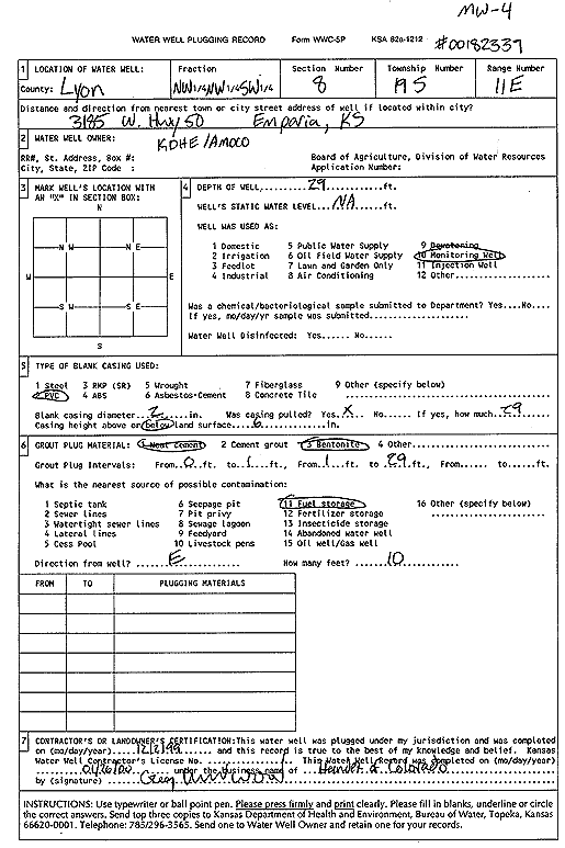
T19S, R11E, Sec. 8 NW NW SW |
KDHE/Amoco | 29 ft. | Monitoring well/observation/piezometer | MW 4 | Plugged | 02-Dec-1999 | Scan | ||
|
T19S, R11E, Sec. 8 SE SW NE |
Lespagnard, George | 53 ft. | 16 ft. | .66 gpm. | Domestic, Lawn and Garden | Constructed | 20-Oct-1979 | ||
|
T19S, R11E, Sec. 8 NE NW NE |
Midwest Petroleum | 18.5 ft. | 7.9 ft. | Monitoring well/observation/piezometer | MW 5 | Constructed | 26-Jan-1995 | ||
|
T19S, R11E, Sec. 8 NW NW NE |
Midwest Petroleum | 19 ft. | 7.79 ft. | Monitoring well/observation/piezometer | MW 2 | Constructed | 25-Jan-1995 | ||
|
T19S, R11E, Sec. 8 NE SW NE |
Mossman, Robert W. | 113 ft. | Domestic, Lawn and Garden | Plugged | 04-Nov-1978 | ||||
|
T19S, R11E, Sec. 8 NW NE SW |
Nelson, Lee E. | 32 ft. | Domestic | Plugged | 09-Dec-1994 | ||||
|
T19S, R11E, Sec. 8 NE SW SE |
S and S Oil and Propane | 29 ft. | 20.01 ft. | Monitoring well/observation/piezometer | MW 9 | Constructed | 09-Feb-1995 | ||
|
T19S, R11E, Sec. 8 NE SW SE |
S and S Oil and Propane | 29 ft. | 17.24 ft. | Monitoring well/observation/piezometer | MW 1 | Constructed | 07-Feb-1995 | ||
|
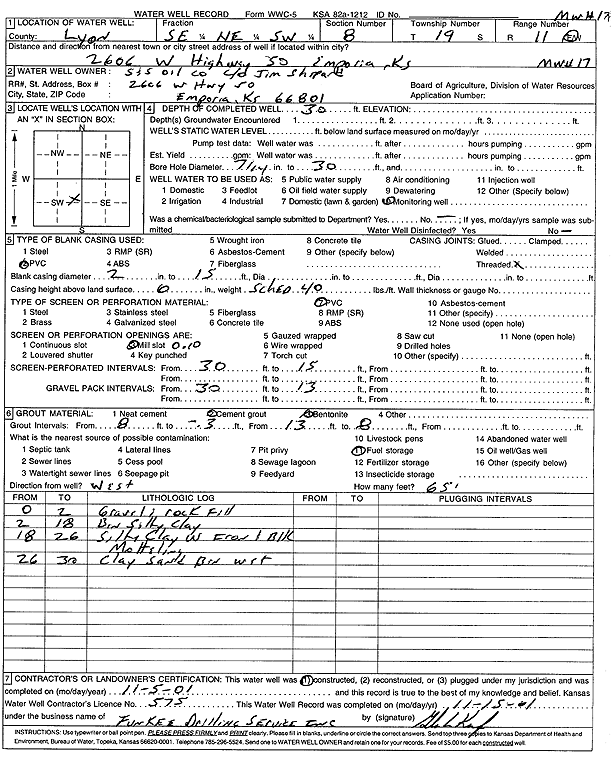
T19S, R11E, Sec. 8 SE NE SW |
S and S Oil and Propane | 30 ft. | Monitoring well/observation/piezometer | MW 17 | Constructed | 05-Nov-2001 | Scan | ||
|
T19S, R11E, Sec. 8 NE SW SE |
S and S Oil and Propane | 29 ft. | 25.46 ft. | Monitoring well/observation/piezometer | MW 11 | Constructed | 10-Feb-1995 | ||
|
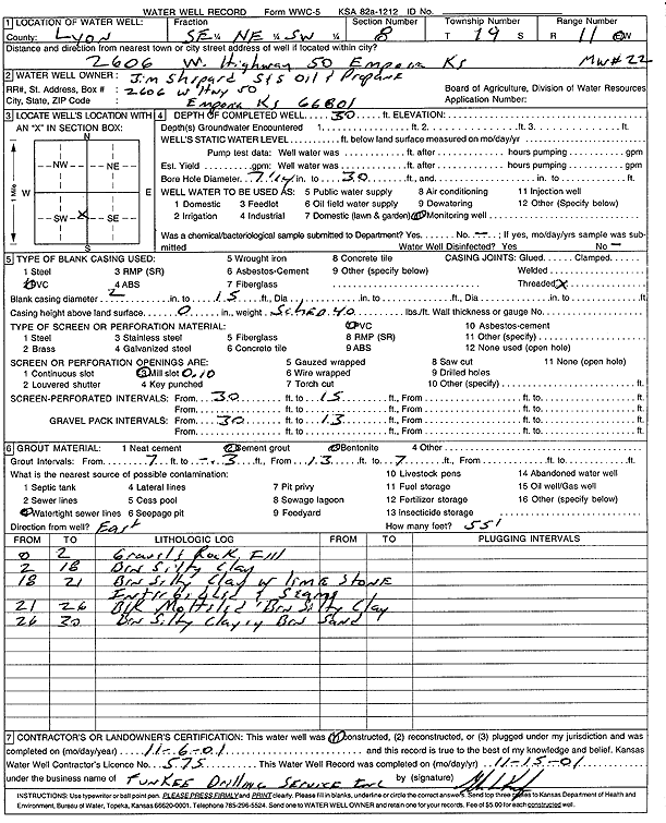
T19S, R11E, Sec. 8 SE NE SW |
S and S Oil and Propane | 30 ft. | Monitoring well/observation/piezometer | MW 22 | Constructed | 06-Nov-2001 | Scan | ||
| View page: < Prev || 11 || 12 || 13 || 14 || 15 || 16 || 17 || 18 || 19 || 20 || Next > | |||||||||