Select location of well to view details.
Click on column heading to sort.
|
|
|
County: McPherson Select location of well to view details. Click on column heading to sort. |
|
|
|
| View page: < Prev || 31 || 32 || 33 || 34 || 35 || 36 || 37 || 38 || 39 || 40 || Next > | |||||||||
| T-R-S | Owner | Well Depth Ascend. Desc. |
Static Water Level Ascend. Desc. |
Est. Yield Ascend. Desc. |
Well Use | Other ID | Action Taken | Completion Date Ascend. Desc. |
Scan? |
|
T19S, R2W, Sec. 2 SE SE SE |
Johnson, Myrtle | 62 ft. | 25 ft. | 25 gpm. | Domestic | Constructed | 12-Jan-1993 | ||
|
T19S, R2W, Sec. 2 SE SE SE |
Johnson, Myrtle | 27 ft. | 25 ft. | Domestic | Plugged | 24-Jan-1993 | |||
|
T19S, R2W, Sec. 2 SW SW SE |
Pitts, Bernard/Blackstone Drilling Co. | 65 ft. | 22 ft. | 70 gpm. | Oil Field Water Supply | Constructed | 04-Jan-1982 | ||
|
T19S, R2W, Sec. 2 SW SE SE |
Thompson, Thomas | 61 ft. | 25 ft. | Domestic | Constructed | 12-Apr-2007 | |||
|
T19S, R2W, Sec. 2 SE SW SE |
Tittle, Josh | 31 ft. | 22 ft. | 16 gpm. | Domestic | Constructed | 13-Apr-2011 | ||
|
T19S, R2W, Sec. 2 SW SE SE |
Tittle, Josh | 200 ft. | 18 ft. | Other | Plugged | 30-Jan-2008 | |||
|
T19S, R2W, Sec. 2 SW SE SE |
Tittle, Josh | 72 ft. | 18 ft. | 40 gpm. | Domestic | Constructed | 04-Feb-2008 | ||
|
T19S, R2W, Sec. 3 SE SW SW |
Blackstone Drilling Co. | 75 ft. | 16 ft. | 100 gpm. | Oil Field Water Supply | Constructed | 03-May-1979 | ||
|
T19S, R2W, Sec. 3 SW SW SW |
Gould, Mike | 75 ft. | 31 ft. | 20 gpm. | Domestic, Livestock | Constructed | 29-Jun-2017 | ||
|
T19S, R2W, Sec. 3 SE SE SW |
Walker, Justin | 75 ft. | 28 ft. | 40 gpm. | Domestic, Lawn and Garden | Constructed | 29-Mar-2024 | KOLAR | |
|
T19S, R2W, Sec. 3 NE NE NE |
Westella, Shawnan | 60 ft. | 28 ft. | 20 gpm. | Domestic | Constructed | 31-Jul-2017 | ||
|
T19S, R2W, Sec. 5 SW SW SE |
Unruh, Cameron | 200 ft. | Heat Pump (Closed Loop/Disposal), Geothermal | Plugged | 26-Mar-2010 | ||||
|
T19S, R2W, Sec. 5 SW SW SE |
Unruh, Cameron | 117 ft. | 20 ft. | 8 gpm. | Domestic | Constructed | 29-Mar-2010 | ||
|
T19S, R2W, Sec. 6 NE SE SE |
Campell, Murice | 98 ft. | 20 ft. | Domestic, Lawn and Garden | Constructed | 06-Jul-1976 | |||
|
T19S, R2W, Sec. 8 NE NW NW |
James, Lee | 74 ft. | 1.5 gpm. | Domestic, Lawn and Garden | Constructed | 13-Oct-2005 | |||
|
T19S, R2W, Sec. 9 SW SW SE SE |
Koehn, Roger | 200 ft. | Geothermal, Closed Loop, Vertical | Constructed | 05-Aug-2014 | ||||
|
T19S, R2W, Sec. 10 NE SE SE |
Becker, Keith | 48 ft. | 16.5 ft. | 80 gpm. | Domestic | Constructed | 29-Mar-1976 | ||
|
T19S, R2W, Sec. 10 N2 NE |
Blackstone Drilling Co. | 60 ft. | 25 ft. | Oil Field Water Supply | Constructed | 29-Jun-1981 | |||
|
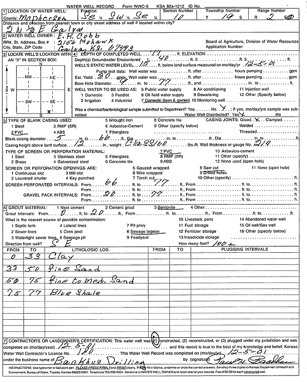
T19S, R2W, Sec. 10 SE SW SE |
Cobb, E.R. | 77 ft. | 15 ft. | 30 gpm. | Domestic, Lawn and Garden | Constructed | 05-Dec-2001 | Scan | |
|
T19S, R2W, Sec. 10 SE SW NW |
Dead Eye Drilling Co. | 60 ft. | 26 ft. | 25 gpm. | Oil Field Water Supply | Constructed | 01-Feb-1981 | ||
|
T19S, R2W, Sec. 10 SW SW NW |
Hess, George R. | 80 ft. | 19 ft. | 60 gpm. | Oil Field Water Supply | Constructed | 25-Sep-1979 | ||
|
T19S, R2W, Sec. 10 C SE |
Howerton, Wilma Lee/Blackstone Drilling | 75 ft. | 30 ft. | Oil Field Water Supply | Constructed | 23-Sep-1983 | |||
|
T19S, R2W, Sec. 10 NW NW SE |
Koehn, Alfred D. | 72 ft. | 24 ft. | 100 gpm. | Oil Field Water Supply | Constructed | 25-Sep-1979 | ||
|
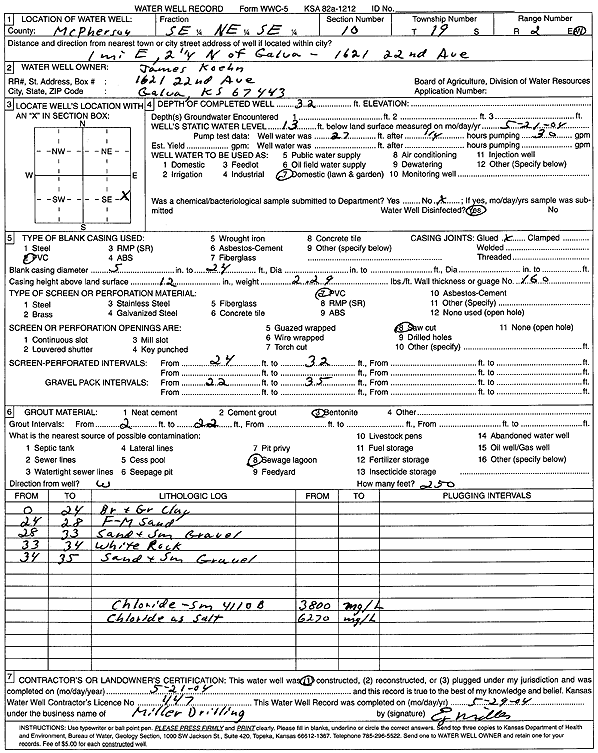
T19S, R2W, Sec. 10 SE NE SE |
Koehn, James | 32 ft. | 13 ft. | Domestic, Lawn and Garden | Constructed | 21-May-2004 | Scan | ||
|
T19S, R2W, Sec. 11 SW SE SE |
American Energies | 66 ft. | 18 ft. | 20 gpm. | Oil Field Water Supply | Constructed | 28-May-2010 | ||
|
T19S, R2W, Sec. 11 C N2 N2 SE |
Big Kat Inc. | 60 ft. | 27 ft. | Oil Field Water Supply | Dunke Berger 1 | Constructed | 15-Sep-1981 | ||
|
T19S, R2W, Sec. 11 SE SE SE |
Big Kat, Inc. | 60 ft. | 13 ft. | Oil Field Water Supply | Dunkel Berger 2 | Constructed | 03-Jan-1982 | ||
|
T19S, R2W, Sec. 11 NW SE SE |
Big Kat, Inc. | 60 ft. | 21 ft. | Oil Field Water Supply | Dunkel Burger | Constructed | 23-Apr-1983 | ||
|
T19S, R2W, Sec. 11 NE SE SW |
Big Kat, Inc. | 50 ft. | 22 ft. | Oil Field Water Supply | Hall 5 | Constructed | 02-Mar-1981 | ||
|
T19S, R2W, Sec. 11 SW SE NE |
Target Drilling/Peel | 56 ft. | 21 ft. | Oil Field Water Supply | Constructed | 08-Feb-1982 | |||
|
T19S, R2W, Sec. 12 SW SW NW |
Big Kat, Inc. | 60 ft. | 20 ft. | Oil Field Water Supply | Ostlind 2 | Constructed | 14-Nov-1981 | ||
|
T19S, R2W, Sec. 12 SW SW SW |
Blackstone Drilling Co. | 56 ft. | 15 ft. | 100 gpm. | Oil Field Water Supply | Constructed | 23-Oct-1981 | ||
|
T19S, R2W, Sec. 12 NW NE NE |
Ratzlaff, Steven | 22 ft. | Domestic | Plugged | 02-Mar-2012 | ||||
|
T19S, R2W, Sec. 12 NW NE NE |
Ratzlaff, Steven | 38 ft. | 26 ft. | Domestic | Plugged | 02-Mar-2012 | |||
|
T19S, R2W, Sec. 12 NW NE NE |
Ratzlaff, Steven | 58 ft. | 31 ft. | Domestic | Plugged | 02-Mar-2012 | |||
|
T19S, R2W, Sec. 12 SE SE SE |
United Center Church | 74 ft. | 27 ft. | 20 gpm. | Domestic | Constructed | 23-Apr-1980 | ||
|
T19S, R2W, Sec. 13 SW NW NW |
Big Kat, Inc. | 60 ft. | 12 ft. | Oil Field Water Supply | Lovett 1 B | Constructed | 22-Sep-1981 | ||
|
T19S, R2W, Sec. 13 NE NW NW |
Blackstone Drilling Co. | 75 ft. | 19 ft. | Oil Field Water Supply | Constructed | 11-Mar-1981 | |||
|
T19S, R2W, Sec. 13 SE SE SW SW |
Kansas Corporation Commission | 85 ft. | Monitoring well/observation/piezometer | Galva 05-02 | Constructed | 02-Jul-2002 | |||
|
T19S, R2W, Sec. 13 NW SW NW SW |
Kansas Corporation Commission | 52 ft. | Monitoring well/observation/piezometer | Galva 06-02 | Constructed | 20-Jun-2002 | |||
|
T19S, R2W, Sec. 13 SE SE SE |
Koehn, Loren | 50 ft. | 19 ft. | 20 gpm. | Domestic, Lawn and Garden | Constructed | 29-Aug-2007 | ||
|
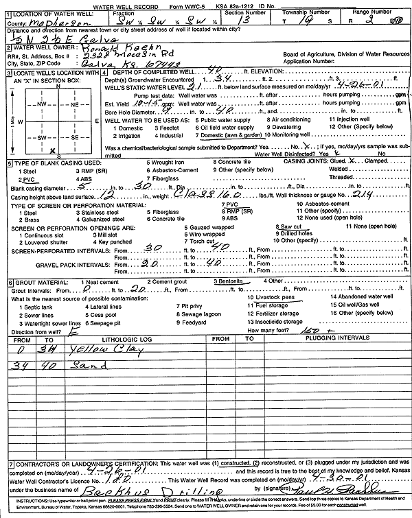
T19S, R2W, Sec. 13 SW SW SW |
Koehn, Ronald | 40 ft. | 21 ft. | 12.5 gpm. | Domestic, Lawn and Garden | Constructed | 26-Apr-2001 | Scan | |
|
T19S, R2W, Sec. 13 SW SE SW |
Koehn, Ronald J. | 50 ft. | 22 ft. | 15 gpm. | Domestic | Constructed | 22-Jul-1994 | ||
|
T19S, R2W, Sec. 14 C W2 W2 NE |
Big Kat, Inc./C.E. Operations | 60 ft. | 18 ft. | Oil Field Water Supply | Griffin B 4 | Constructed | 22-Mar-1983 | ||
|
T19S, R2W, Sec. 14 NW SE NE |
Blackstone Drilling Co. | 55 ft. | 21 ft. | Oil Field Water Supply | Constructed | 27-Mar-1981 | |||
|
T19S, R2W, Sec. 14 NW NW SW |
Blackstone Drilling Co. | 60 ft. | 19.5 ft. | Oil Field Water Supply | Constructed | 20-Jan-1981 | |||
|
T19S, R2W, Sec. 14 NW NW NW |
Blackstone Drilling, Inc. | 57 ft. | 18 ft. | Oil Field Water Supply | Constructed | 30-Jan-1980 | |||
|
T19S, R2W, Sec. 14 NW NW NW |
Cain, Glen/Red Tiger Drilling | 45 ft. | 20 ft. | Oil Field Water Supply | Plugged | 06-Jun-1985 | |||
|
T19S, R2W, Sec. 14 SW SW SE |
Koehn, Roland | 35 ft. | 14 ft. | 25 gpm. | Domestic, Lawn and Garden | Constructed | 11-Sep-1984 | ||
|
T19S, R2W, Sec. 14 SW NW NW |
Krehbiel, Homer | 65 ft. | 20 ft. | 35 gpm. | Oil Field Water Supply | Constructed | 27-Sep-1982 | ||
| View page: < Prev || 31 || 32 || 33 || 34 || 35 || 36 || 37 || 38 || 39 || 40 || Next > | |||||||||