Select location of well to view details.
Click on column heading to sort.
|
|
|
County: Meade Select location of well to view details. Click on column heading to sort. |
|
|
|
| View page: < Prev || 31 || 32 || 33 || 34 || 35 || 36 || 37 || 38 || 39 || 40 || Next > | |||||||||
| T-R-S | Owner | Well Depth Ascend. Desc. |
Static Water Level Ascend. Desc. |
Est. Yield Ascend. Desc. |
Well Use | Other ID | Action Taken | Completion Date Ascend. Desc. |
Scan? |
|
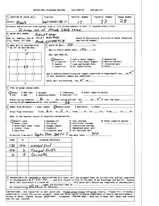
T33S, R28W, Sec. 17 NW NW NE |
Wiens, Rolland K | 130 ft. | 106 ft. | Domestic | Plugged | 22-Jan-1999 | Scan | ||
|
T33S, R28W, Sec. 19 SW SE NW |
Diamond Shamrock Co | 380 ft. | 107 ft. | 50 gpm. | Oil Field Water Supply | Feldman 3 | Constructed | 29-Jul-1980 | |
|
T33S, R28W, Sec. 19 SW NE SE |
Diamond Shamrock Co | 220 ft. | 52 ft. | 60 gpm. | Oil Field Water Supply | Reimer 2 | Constructed | 06-Jul-1981 | |
|
T33S, R28W, Sec. 19 E2 SW SE |
Diamond Shamrock Co | 240 ft. | 65 ft. | 60 gpm. | Oil Field Water Supply | Reimer 1 | Constructed | 11-Aug-1980 | |
|
T33S, R28W, Sec. 19 SE SE SW |
Diamond Shamrock Co | 280 ft. | 70 ft. | 60 gpm. | Oil Field Water Supply | Feldman 2 | Constructed | 07-Jul-1980 | |
|
T33S, R28W, Sec. 19 SW SW SW |
Quick, David | 178 ft. | 39 ft. | 1850 gpm. | Irrigation | Constructed | 05-Jun-1998 | ||
|
T33S, R28W, Sec. 21 SW SW NE |
Nash, Roscoe | 220 ft. | 147 ft. | 60 gpm. | Oil Field Water Supply | Nash 1-21 | Constructed | 13-May-1982 | |
|
T33S, R28W, Sec. 22 SW NW NW |
Ediger, J P | 220 ft. | 160 ft. | 60 gpm. | Oil Field Water Supply | Ediger 1 | Constructed | 20-Jul-1983 | |
|
T33S, R28W, Sec. 23 NE NE NE |
Sage Drilling | 206 ft. | 126 ft. | 40 gpm. | Oil Field Water Supply | Constructed | 27-Jul-1983 | ||
|
T33S, R28W, Sec. 25 SW NW NE |
Friesen, Alfred | 178 ft. | 147 ft. | 125 gpm. | Domestic | Constructed | 17-Nov-1977 | ||
|
T33S, R28W, Sec. 26 SW SE SE |
Isaac, Melvin | 200 ft. | 138 ft. | Domestic | Plugged | 03-Aug-1992 | |||
|
T33S, R28W, Sec. 26 SW NE NE |
Tennis, Dean E | 111 ft. | 106 ft. | Domestic | Plugged | 14-Sep-2000 | |||
|
T33S, R28W, Sec. 26 SW NE NE |
Tennis, Dean E. | 160 ft. | 105 ft. | 10 gpm. | Domestic | Constructed | 09-Sep-2000 | ||
|
T33S, R28W, Sec. 27 NW NE NE SE |
Cunningham, Matt | 215 ft. | 145 ft. | 40 gpm. | Domestic | Constructed | 08-Jul-2008 | ||
|
T33S, R28W, Sec. 27 SW NW |
Sage Drilling | 220 ft. | 115 ft. | 60 gpm. | Oil Field Water Supply | Heinson 1-27 | Constructed | 06-Jun-1979 | |
|
T33S, R28W, Sec. 28 C NW SE |
Sage Drilling | 240 ft. | 170 ft. | 40 gpm. | Oil Field Water Supply | Hension 1-28 | Constructed | 17-Dec-1979 | |
|
T33S, R28W, Sec. 29 NW NW SW |
Blehm, Margaret | 100 ft. | 14 ft. | Domestic | Constructed | 29-Jul-1995 | |||
|
T33S, R28W, Sec. 30 NE NE SW |
Diamond Shamrock Co | 200 ft. | 15 ft. | 60 gpm. | Oil Field Water Supply | Eckhoff 1 | Constructed | 27-Aug-1980 | |
|
T33S, R28W, Sec. 30 N2 NW |
Diamond Shamrock Co | 240 ft. | 52 ft. | 60 gpm. | Oil Field Water Supply | Feldman 3 | Constructed | 11-Jun-1980 | |
|
T33S, R28W, Sec. 30 NW NW NE |
Diamond Shamrock Co | 254 ft. | 51 ft. | 100 gpm. | Oil Field Water Supply | Constructed | 16-Sep-1980 | ||
|
T33S, R28W, Sec. 30 SW NE SW |
Diamond Shamrock Co | 137 ft. | 19 ft. | 150 gpm. | Oil Field Water Supply | Constructed | 26-Sep-1980 | ||
|
T33S, R28W, Sec. 30 W2 NE NE |
Diamond Shamrock Co | 260 ft. | 45 ft. | 60 gpm. | Oil Field Water Supply | Feldman 4 | Constructed | 22-Aug-1980 | |
|
T33S, R28W, Sec. 30 NE SW NE |
Hissom, Charles | 126 ft. | 15 ft. | 5 gpm. | Domestic, Livestock | Constructed | 20-Jan-1977 | ||
|
T33S, R28W, Sec. 30 SE SE NW |
Midco Drilling Co | 200 ft. | 8 ft. | 70 gpm. | Oil Field Water Supply | Feldman 1 | Constructed | 09-Jan-1980 | |
|
T33S, R28W, Sec. 30 C SE |
Sage Drilling | 60 ft. | 3 ft. | 60 gpm. | Oil Field Water Supply | Hossom 1-30 | Constructed | 14-Jun-1978 | |
|
T33S, R28W, Sec. 30 C SW SW NE |
Sage Drilling | 50 ft. | 12 ft. | 30 gpm. | Oil Field Water Supply | Hissom 1 | Constructed | 21-Nov-1978 | |
|
T33S, R28W, Sec. 31 NW NE SE NE |
Hawley, Rocky | 150 ft. | 16 ft. | 50 gpm. | Domestic | Constructed | 06-Jul-2015 |
KOLAR |
|
|
T33S, R28W, Sec. 31 C N2 NE |
Hissom, Charles | 240 ft. | 2 ft. | Oil Field Water Supply | Constructed | 15-Mar-1984 | |||
|
T33S, R28W, Sec. 31 NE NW NE |
Mesa Petroleum Co | 240 ft. | Oil Field Water Supply | Plugged | 19-Aug-1984 | ||||
|
T33S, R28W, Sec. 31 NE NW NE |
Mesa Petroleum Co | 240 ft. | Oil Field Water Supply | Plugged | 19-Aug-1984 | ||||
|
T33S, R28W, Sec. 31 NE NW NE |
Mesa Petroleum Co | 240 ft. | Oil Field Water Supply | Plugged | 19-Aug-1984 | ||||
|
T33S, R28W, Sec. 32 NW SE SW |
Damac Drilling Co. | 100 ft. | 6 ft. | 100 gpm. | Oil Field Water Supply | Johanssen | Constructed | 21-Mar-1983 | |
|
T33S, R28W, Sec. 32 NW NE SE |
Johannsen, Max | 100 ft. | 58 ft. | 3 gpm. | Domestic | Constructed | 13-Mar-1995 | ||
|
T33S, R28W, Sec. 32 NW NW NW |
Slawson Drilling Co. | 160 ft. | 5 ft. | 85 gpm. | Oil Field Water Supply | Blehm 3 A | Constructed | 28-Mar-1983 | |
|
T33S, R28W, Sec. 33 NW NE NW |
Heinson, Harold | 163 ft. | 10 ft. | 100 gpm. | Domestic, Livestock | Constructed | 15-Feb-1977 | ||
|
T33S, R28W, Sec. 35 C SW NW |
H-30 Drilling, Inc. | 200 ft. | 140 ft. | 95 gpm. | Oil Field Water Supply | Constructed | 20-Oct-1989 | ||
|
T33S, R28W, Sec. 36 SE SE NE |
Isaac, Melvin | 180 ft. | 108 ft. | 50 gpm. | Domestic | Constructed | 24-May-1995 | ||
|
T33S, R28W, Sec. 36 SW NE NW |
Isaac, Melvin | 87 ft. | 73 ft. | Domestic | Plugged | 06-Jul-1995 | |||
|
T33S, R29W, Sec. 2 SE SE SW |
Barragree, Joe | 100 ft. | Domestic | Plugged | 05-May-1997 | ||||
|
T33S, R29W, Sec. 2 SE SE SW |
Vanderpool, J W | 220 ft. | 42 ft. | 50 gpm. | Domestic | Constructed | 05-Sep-1986 | ||
|
T33S, R29W, Sec. 3 NW SW NE |
Atchinson, Irvin | 160 ft. | 95 ft. | 25 gpm. | Domestic, Livestock | Well 12 | Constructed | 10-Feb-1977 | |
|
T33S, R29W, Sec. 3 NE NE SW |
Barragree, Joe | 60 ft. | Domestic | Plugged | 02-May-1996 | ||||
|
T33S, R29W, Sec. 4 NE SE SW |
Keystone Grazing | 160 ft. | 81 ft. | 20 gpm. | Domestic | Constructed | 14-Jun-1988 | ||
|
T33S, R29W, Sec. 5 N2 NE SE |
Deck Oil | 160 ft. | 100 ft. | 75 gpm. | Oil Field Water Supply | Constructed | 14-Jul-1983 | ||
|
T33S, R29W, Sec. 5 SW NW SE |
Grace, Thomas | 270 ft. | 118 ft. | 75 gpm. | Oil Field Water Supply | Keystone 1-5 | Constructed | 24-Jul-1985 | |
|
T33S, R29W, Sec. 5 NW SE NE |
Keystone Grazing | 312 ft. | 145 ft. | 50 gpm. | Domestic | Constructed | 10-Jan-2006 | ||
|
T33S, R29W, Sec. 5 SW SW NW |
Sage Drilling Co. | 300 ft. | 170 ft. | 60 gpm. | Industrial | Constructed | 25-Oct-1974 | Scan | |
|
T33S, R29W, Sec. 6 SE SW NE |
Evans Energy LLC | 420 ft. | 200 ft. | 100 gpm. | Oil Field Water Supply | Angell 4-6 | Constructed | 23-Oct-2012 | |
|
T33S, R29W, Sec. 7 NW NW SW |
Belvins, Dustin | 480 ft. | 252 ft. | 20 gpm. | Domestic, Livestock | Constructed | 03-Jan-2025 |
KOLAR |
|
|
T33S, R29W, Sec. 7 NE SE NE |
Bolan, Bill | 157 ft. | 127 ft. | Domestic | Plugged | 09-May-2006 | |||
| View page: < Prev || 31 || 32 || 33 || 34 || 35 || 36 || 37 || 38 || 39 || 40 || Next > | |||||||||