Select location of well to view details.
Click on column heading to sort.
|
|
|
County: Meade Select location of well to view details. Click on column heading to sort. |
|
|
|
| View page: 1 || 2 || 3 || 4 || 5 || 6 || 7 || 8 || 9 || 10 || Next > | |||||||||
| T-R-S | Owner | Well Depth Ascend. Desc. |
Static Water Level Ascend. Desc. |
Est. Yield Ascend. Desc. |
Well Use | Other ID | Action Taken | Completion Date Ascend. Desc. |
Scan? |
|
T30S, R30W, Sec. 13 SE SW |
Grace, Jerry | 425 ft. | 173 ft. | 1100 gpm. | Irrigation | Constructed | 08-Apr-1975 | ||
|
T30S, R30W, Sec. 14 NW NE NE |
Corbin, Harry | 455 ft. | 270 ft. | 1600 gpm. | Irrigation | Constructed | 21-Mar-2007 | ||
|
T30S, R30W, Sec. 14 SE NE SW |
Corbin, Harry F. | 410 ft. | 178 ft. | 2250 gpm. | Irrigation | Constructed | 24-May-1975 | ||
|
T30S, R30W, Sec. 14 NW SE NW |
Corbin, Jeff | 362 ft. | 220 ft. | 1500 gpm. | Irrigation | Reconstructed | 21-May-1991 | ||
|
T30S, R30W, Sec. 15 SE SE NE |
Corbin, Harry F., III | 420 ft. | 267 ft. | 900 gpm. | Irrigation | Constructed | 26-May-2010 | ||
|
T30S, R30W, Sec. 15 SW SE SE NW |
G & J Fund | 509 ft. | 292 ft. | 900 gpm. | Irrigation | Constructed | 01-Jul-2020 |
KOLAR |
|
|
T30S, R30W, Sec. 15 SW SE NW |
G and J Fund | 406 ft. | 232 ft. | Irrigation | Constructed | 20-Apr-2001 | Scan | ||
|
T30S, R30W, Sec. 16 SE SE NE |
Gibson, Ronnie and Jacqueline | 508 ft. | 309 ft. | 1000 gpm. | Irrigation | Constructed | 01-Jul-2025 |
KOLAR |
|
|
T30S, R30W, Sec. 16 SE NE NE |
Gibson, Thomas | 380 ft. | 165 ft. | 2000 gpm. | Irrigation | Constructed | 14-Mar-1977 | ||
|
T30S, R30W, Sec. 16 NW SE NW |
Kohart, Bud | 446 ft. | 167 ft. | 1450 gpm. | Irrigation | Constructed | 28-Feb-1977 | ||
|
T30S, R30W, Sec. 16 SE SE SE |
Plains Equity Exchange | 455 ft. | 260 ft. | 50 gpm. | Domestic | Constructed | 14-Apr-2016 | ||
|
T30S, R30W, Sec. 17 SW NE SW |
Copeland United Methodist Church | 420 ft. | 169 ft. | 2200 gpm. | Irrigation | Constructed | 15-Aug-1975 | ||
|
T30S, R30W, Sec. 17 NW NW NE NW |
McCoy Petroleum Corp. | 380 ft. | 116 ft. | 180 gpm. | Oil Field Water Supply | O'Brate-UMCC 1H-17 | Constructed | 15-Jun-2018 |
KOLAR |
|
T30S, R30W, Sec. 17 SW SW SE |
United Methodist Church | 405 ft. | 245 ft. | 1500 gpm. | Irrigation | Constructed | 08-Apr-2010 | ||
|
T30S, R30W, Sec. 18 SE SE NW |
Koehn, Danny | 440 ft. | 265 ft. | 1000 gpm. | Irrigation | Constructed | 19-Mar-2010 | ||
|
T30S, R30W, Sec. 18 SW SE SW SE |
Koehn, Loren and Marsha | 560 ft. | 304 ft. | 700 gpm. | Irrigation | Constructed | 20-Oct-2015 |
KOLAR |
|
|
T30S, R30W, Sec. 18 NW SW |
Schwab, Don | 415 ft. | 220 ft. | 1300 gpm. | Irrigation | Constructed | 14-Aug-1986 | ||
|
T30S, R30W, Sec. 19 N2 SE |
Ensign Operating Co. | 360 ft. | 220 ft. | Oil Field Water Supply | Koehn 1-19 | Plugged | 16-May-1995 | ||
|
T30S, R30W, Sec. 19 N2 SE |
Ensign Operating Co. | 360 ft. | 220 ft. | 90 gpm. | Oil Field Water Supply | Koehn 1-19 | Constructed | 13-Mar-1995 | |
|
T30S, R30W, Sec. 19 NW SW NW |
Koehn, Lorin | 420 ft. | 255 ft. | Irrigation | Constructed | 23-May-2003 | Scan | ||
|
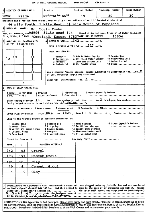
T30S, R30W, Sec. 19 NW SW NW |
Koehn, Lorin | 342 ft. | 277 ft. | Irrigation | Plugged | 22-Feb-2003 | Scan | ||
|
T30S, R30W, Sec. 19 SW SW NE |
Koehn, Lorin D. and Marsha L. | 525 ft. | 306 ft. | Irrigation | Constructed | 03-Apr-2024 |
KOLAR |
||
|
T30S, R30W, Sec. 19 SW SE NE |
Schwab, Don | 405 ft. | 230 ft. | Irrigation | Plugged | 08-May-1990 | |||
|
T30S, R30W, Sec. 19 SE SW NE |
Schwab, Don | 410 ft. | 229 ft. | Irrigation | Constructed | 08-May-1990 | |||
|
T30S, R30W, Sec. 20 SE |
Koehn, Gene | 392 ft. | 287 ft. | Irrigation | Plugged | 02-Oct-2013 | |||
|
T30S, R30W, Sec. 20 SE SW SE NE |
Koehn, Gene | 527 ft. | 262 ft. | 1590 gpm. | Irrigation | Constructed | 31-May-2013 |
KOLAR |
|
|
T30S, R30W, Sec. 20 NW NW SE |
Unruh, David R. | 380 ft. | 230 ft. | Irrigation | Constructed | 24-May-1996 | |||
|
T30S, R30W, Sec. 22 SW NE NE |
Koehn, Paul | 440 ft. | 230 ft. | Irrigation | Constructed | 16-Mar-2007 | |||
|
T30S, R30W, Sec. 22 NE NE NE |
Koehn, Paul | 410 ft. | 230 ft. | Irrigation | Plugged | 05-May-2007 | |||
|
T30S, R30W, Sec. 23 SW SW SW |
Chappell, Jerry | 304 ft. | 270 ft. | Domestic | Plugged | 11-Nov-2024 |
KOLAR |
||
|
T30S, R30W, Sec. 23 SW SW SW |
Chappell, Jerry | 410 ft. | 270 ft. | Domestic | Constructed | 04-Nov-2024 |
KOLAR |
||
|
T30S, R30W, Sec. 23 SW SW SW |
Chappell, Louis | 333 ft. | 155 ft. | Domestic | Constructed | 10-May-1978 | |||
|
T30S, R30W, Sec. 24 SE SW |
Koesser, Bob | 410 ft. | 169 ft. | 2500 gpm. | Irrigation | Constructed | 16-Feb-1981 | ||
|
T30S, R30W, Sec. 24 SW NE SW |
Koesser, Bob | 415 ft. | 179 ft. | 1250 gpm. | Irrigation | Constructed | 10-Jan-1977 | ||
|
T30S, R30W, Sec. 26 SE SE |
Rains and Williamson Oil Co. | 280 ft. | 170 ft. | 20 gpm. | Oil Field Water Supply | Hobart 1 | Constructed | 14-Jul-1977 | |
|
T30S, R30W, Sec. 28 NE NW NW NE |
Chappell, Jerry | 537 ft. | 282 ft. | 1514 gpm. | Irrigation | Constructed | 30-Mar-2021 |
KOLAR |
|
|
T30S, R30W, Sec. 28 NW NW NE |
Chappell, Louis | 517 ft. | 225 ft. | Irrigation | Plugged | 25-Feb-2000 | |||
|
T30S, R30W, Sec. 29 SW SE SE |
Unruh, Leslie J | 400 ft. | 274 ft. | 1300 gpm. | Irrigation | Constructed | 14-Jun-2011 | ||
|
T30S, R30W, Sec. 29 NW SW SE |
Unruh, Leslie J. | 420 ft. | 286 ft. | 1100 gpm. | Irrigation | Constructed | 04-Feb-2008 | ||
|
T30S, R30W, Sec. 30 W2 SW SW |
Barnhardt, Gordon | 511 ft. | 191 ft. | 1500 gpm. | Irrigation | Constructed | 16-Oct-1978 | ||
|
T30S, R30W, Sec. 30 NW SW SW |
County Line Partnership | 510 ft. | 280 ft. | Irrigation | Constructed | 19-Feb-2013 | |||
|
T30S, R30W, Sec. 30 NW SW SW |
Isaac, Tom | 545 ft. | 305 ft. | 400 gpm. | Irrigation | Constructed | 26-Mar-2025 |
KOLAR |
|
|
T30S, R30W, Sec. 30 NE NE SE |
Koehn, Lawrence | 315 ft. | 183 ft. | 80 gpm. | Domestic | Constructed | 27-Feb-1975 | ||
|
T30S, R30W, Sec. 30 SW SW SE |
Koehn, Lawrence G. and Verna J. | 420 ft. | 256 ft. | Irrigation | Constructed | 05-Oct-2004 | |||
|
T30S, R30W, Sec. 30 NE NE NW |
Smith, Randell | 350 ft. | 180 ft. | 20 gpm. | Domestic | Constructed | 28-Mar-1990 | ||
|
T30S, R30W, Sec. 31 SW SW NW |
Haley, Eugene | 543 ft. | 193 ft. | 2500 gpm. | Irrigation | Constructed | 05-Jun-1980 | ||
|
T30S, R30W, Sec. 31 NW SW NE |
Hulburt, Pauline | 438 ft. | 207 ft. | 1500 gpm. | Irrigation | Constructed | 04-Apr-1995 | ||
|
T30S, R30W, Sec. 31 C NE |
Hulburt, Pauline | 390 ft. | 241 ft. | Irrigation | Plugged | 02-May-1995 | |||
|
T30S, R30W, Sec. 31 NE |
Hulburt, Walter and Pauline | 390 ft. | 185 ft. | 1400 gpm. | Irrigation | Constructed | 30-Jun-1980 | ||
|
T30S, R30W, Sec. 33 SE |
Winfrey, Darrell | 440 ft. | 180 ft. | 1650 gpm. | Irrigation | Constructed | 18-Nov-1977 | ||
| View page: 1 || 2 || 3 || 4 || 5 || 6 || 7 || 8 || 9 || 10 || Next > | |||||||||