Select location of well to view details.
Click on column heading to sort.
|
|
|
County: Montgomery Select location of well to view details. Click on column heading to sort. |
|
|
|
| View page: < Prev || 11 || 12 || 13 || 14 || 15 || 16 || 17 || 18 || 19 || 20 || Next > | |||||||||
| T-R-S | Owner | Well Depth Ascend. Desc. |
Static Water Level Ascend. Desc. |
Est. Yield Ascend. Desc. |
Well Use | Other ID | Action Taken | Completion Date Ascend. Desc. |
Scan? |
|
T32S, R16E, Sec. 32 SW NE SE |
Heartland Cement Company | 80.5 ft. | 32 ft. | Monitoring well/observation/piezometer | 3 D | Plugged | 24-Feb-2009 | ||
|
T32S, R16E, Sec. 32 SW NE SE |
Heartland Cement Company | 80 ft. | 5.47 ft. | Monitoring well/observation/piezometer | OLGW 7 D | Constructed | 05-Mar-2009 | ||
|
T32S, R16E, Sec. 32 SW NE SE |
Heartland Cement Company | 38 ft. | 29.68 ft. | Monitoring well/observation/piezometer | OLGW 11 | Constructed | 24-Feb-2009 | ||
|
T32S, R16E, Sec. 32 SW NE SE |
Heartland Cement Company | 19.5 ft. | 8.29 ft. | Monitoring well/observation/piezometer | OLGW 10 | Constructed | 24-Feb-2009 | ||
|
T32S, R16E, Sec. 32 SW NE SE |
Heartland Cement Company | 78 ft. | 30 ft. | Monitoring well/observation/piezometer | 3 DR | Plugged | 24-Feb-2009 | ||
|
T32S, R16E, Sec. 32 SW NE SE |
Heartland Cement Company | 22 ft. | 8.29 ft. | Monitoring well/observation/piezometer | OLGW 9 | Constructed | 24-Feb-2009 | ||
|
T32S, R16E, Sec. 32 SW NE SE |
Heartland Cement Company | 22 ft. | 8.51 ft. | Monitoring well/observation/piezometer | OLGW 8 | Constructed | 24-Feb-2009 | ||
|
T32S, R16E, Sec. 32 SW NE SE |
Heartland Cement Company | 95 ft. | 29.81 ft. | Monitoring well/observation/piezometer | OLGW 1 D | Constructed | 27-Feb-2009 | ||
|
T32S, R16E, Sec. 33 C NE NE |
Livingston, Andrew D. | 40 ft. | 12 ft. | 3 gpm. | Domestic, Livestock | Constructed | 13-Jun-1977 | ||
|
T32S, R17E, Sec. 5 NE NW |
Jones, Wayne | 102 ft. | 42 ft. | .5 gpm. | Domestic | Constructed | 22-Apr-1981 | ||
|
T32S, R17E, Sec. 8 NE SE SE |
Greenfield Environmental | 9.8 ft. | Monitoring well/observation/piezometer | MW 7 | Plugged | 20-Oct-2016 | |||
|
T32S, R17E, Sec. 8 NE SE SE |
Greenfield Environmental | 14.74 ft. | Monitoring well/observation/piezometer | MW 8 | Plugged | 20-Oct-2016 | |||
|
T32S, R17E, Sec. 8 NE SE SE |
Greenfield Environmental | 14.8 ft. | 5.84 ft. | Monitoring well/observation/piezometer | MW 8 | Constructed | 18-Mar-2015 | ||
|
T32S, R17E, Sec. 8 NE SE SE |
Greenfield Environmental | 9.54 ft. | 5.71 ft. | Monitoring well/observation/piezometer | MW 7 | Constructed | 17-Mar-2015 | ||
|
T32S, R17E, Sec. 8 SE NE SE SE |
Gurpreet, Panesar | 11.5 ft. | Monitoring well/observation/piezometer | MW 3 | Plugged | 04-Jan-2016 | |||
|
T32S, R17E, Sec. 8 SE SE SE |
National Zinc Co. | 12 ft. | 3 ft. | Test hole/well | B 2 of 1 | Constructed | 27-Apr-1978 | ||
|
T32S, R17E, Sec. 8 SW NW NW |
National Zinc Co. | 14 ft. | 8 ft. | Test hole/well | B 3 | Constructed | 27-Apr-1978 | ||
|
T32S, R17E, Sec. 8 SE SE SE |
National Zinc Co. | 19 ft. | 6 ft. | Test hole/well | B 2 of 2 | Constructed | 26-Apr-1978 | ||
|
T32S, R17E, Sec. 8 SW SW NE |
National Zinc Co. | 17 ft. | 8 ft. | Test hole/well | B 1 | Constructed | 26-Apr-1978 | ||
|
T32S, R17E, Sec. 8 N2 NW SE SE |
National Zinc Co. | 16 ft. | 12 ft. | Test hole/well | B 4 | Constructed | 27-Apr-1978 | ||
|
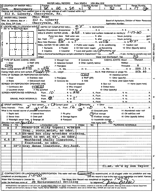
T32S, R17E, Sec. 8 SE SE SE |
Near, Phil | 10.25 ft. | 6.52 ft. | Monitoring well/observation/piezometer | Constructed | 11-Jan-2000 | Scan | ||
|
T32S, R17E, Sec. 8 SE SE SE |
Panesar, Gurpreet | 10.5 ft. | Monitoring well/observation/piezometer | MW 1 | Constructed | 04-Sep-2012 | |||
|
T32S, R17E, Sec. 8 SE SE SE |
Panesar, Gurpreet | 11.11 ft. | 3.95 ft. | Monitoring well/observation/piezometer | MW 7 | Constructed | 23-Apr-2013 | ||
|
T32S, R17E, Sec. 8 SE SE SE |
Panesar, Gurpreet | 7.8 ft. | 6.13 ft. | Monitoring well/observation/piezometer | MW 8 | Constructed | 23-Apr-2013 | ||
|
T32S, R17E, Sec. 8 SE SE SE |
Panesar, Gurpreet | 11.65 ft. | 5 ft. | Monitoring well/observation/piezometer | MW 9 | Constructed | 23-Apr-2013 | ||
|
T32S, R17E, Sec. 8 NE SE SE |
Panesar, Gurpreet | 7.1 ft. | Monitoring well/observation/piezometer | MW 5 | Constructed | 04-Sep-2012 | |||
|
T32S, R17E, Sec. 8 SE SE SE |
Panesar, Gurpreet | 11.95 ft. | Monitoring well/observation/piezometer | MW 2 | Constructed | 04-Sep-2012 | |||
|
T32S, R17E, Sec. 8 NE SE SE |
Panesar, Gurpreet | 11 ft. | Monitoring well/observation/piezometer | MW 4 | Constructed | 04-Sep-2012 | |||
|
T32S, R17E, Sec. 8 SE SE SE |
Panesar, Gurpreet | 9.6 ft. | 3.95 ft. | Monitoring well/observation/piezometer | MW 10 | Constructed | 23-Apr-2013 | ||
|
T32S, R17E, Sec. 8 SE SE SE |
Panesar, Gurpreet | 9.95 ft. | 3.79 ft. | Monitoring well/observation/piezometer | MW 6 | Constructed | 23-Apr-2013 | ||
|
T32S, R17E, Sec. 8 NE SE SE |
Panesar, Gurpreet | 14.85 ft. | Monitoring well/observation/piezometer | MW 3 | Constructed | 04-Sep-2012 | |||
|
T32S, R17E, Sec. 8 SE SE SE |
Panesar, Gurpreet | 7.7 ft. | Monitoring well/observation/piezometer | MW 8 | Plugged | 16-Oct-2019 | |||
|
T32S, R17E, Sec. 8 SE SE SE |
Panesar, Gurpreet | 9.9 ft. | Monitoring well/observation/piezometer | MW 6 | Plugged | 16-Oct-2019 | |||
|
T32S, R17E, Sec. 8 NE SE SE SE |
Panesar, Gurpreet | 9.8 ft. | Monitoring well/observation/piezometer | MW 2 R | Plugged | 16-Oct-2019 | |||
|
T32S, R17E, Sec. 8 SE SE SE |
Panesar, Gurpreet | 11.4 ft. | Monitoring well/observation/piezometer | MW 9 | Plugged | 16-Oct-2019 | |||
|
T32S, R17E, Sec. 8 NE SE SE |
Panesar, Gurpreet | 10.7 ft. | Monitoring well/observation/piezometer | MW 4 | Plugged | 16-Oct-2019 | |||
|
T32S, R17E, Sec. 8 SE NE SE SE |
Panesar, Gurpreet | 10 ft. | Monitoring well/observation/piezometer | MW 3 R | Plugged | 16-Oct-2019 | |||
|
T32S, R17E, Sec. 8 SE SE SE |
Panesar, Gurpreet | 7.3 ft. | Monitoring well/observation/piezometer | MW 1 | Plugged | 16-Oct-2019 | |||
|
T32S, R17E, Sec. 8 SE NE SE SE |
Panesar, Gurpreet | 10 ft. | 6.31 ft. | Monitoring well/observation/piezometer | MW 3 R | Constructed | 28-Mar-2019 | ||
|
T32S, R17E, Sec. 8 NE SE SE SE |
Panesar, Gurpreet | 10.25 ft. | 6.25 ft. | Monitoring well/observation/piezometer | MW 2 R | Constructed | 28-Mar-2019 | ||
|
T32S, R17E, Sec. 8 NE SE SE SE |
Panesar, Gurpreet | 3 ft. | Monitoring well/observation/piezometer | MW 2 | Plugged | 26-Jun-2018 | |||
|
T32S, R17E, Sec. 8 SE SE SE |
Panesar, Gurpreet | 9.7 ft. | Monitoring well/observation/piezometer | MW 10 | Plugged | 16-Oct-2019 | |||
|
T32S, R17E, Sec. 8 NE SE SE |
Panesar, Gurpreet | 7 ft. | Monitoring well/observation/piezometer | MW 5 | Plugged | 16-Oct-2019 | |||
|
T32S, R17E, Sec. 8 SE SE SE |
Panesar, Gurpreet | 11 ft. | Monitoring well/observation/piezometer | MW 7 | Plugged | 16-Oct-2019 | |||
|
T32S, R17E, Sec. 8 NE SE SW NE |
Project Navigator | 16 ft. | 7.21 ft. | Monitoring well/observation/piezometer | LFI-7S | Plugged | 02-Apr-2020 |
KOLAR |
|
|
T32S, R17E, Sec. 8 SE SE NE NE |
Project Navigator | 21.5 ft. | 15 ft. | Monitoring well/observation/piezometer | LFI-1 | Constructed | 26-Mar-2018 | ||
|
T32S, R17E, Sec. 8 NE NE SW NE |
Project Navigator | 21 ft. | 15.13 ft. | Monitoring well/observation/piezometer | LFI-3 | Plugged | 02-Apr-2020 |
KOLAR |
|
|
T32S, R17E, Sec. 8 NW SW SE NE |
Project Navigator | 30 ft. | 27 ft. | Monitoring well/observation/piezometer | LFI-2 | Plugged | 02-Apr-2020 |
KOLAR |
|
|
T32S, R17E, Sec. 8 NE SE SW NE |
Project Navigator | 20 ft. | 7.13 ft. | Monitoring well/observation/piezometer | LFI-7D | Plugged | 02-Apr-2020 |
KOLAR |
|
|
T32S, R17E, Sec. 8 SW SE NE NE |
Project Navigator | 30 ft. | 27 ft. | Monitoring well/observation/piezometer | LFI-2 | Constructed | 27-Mar-2018 | ||
| View page: < Prev || 11 || 12 || 13 || 14 || 15 || 16 || 17 || 18 || 19 || 20 || Next > | |||||||||