Select location of well to view details.
Click on column heading to sort.
|
|
|
County: Montgomery Select location of well to view details. Click on column heading to sort. |
|
|
|
| View page: < Prev || 11 || 12 || 13 || 14 || 15 || 16 || 17 || 18 || 19 || 20 || Next > | |||||||||
| T-R-S | Owner | Well Depth Ascend. Desc. |
Static Water Level Ascend. Desc. |
Est. Yield Ascend. Desc. |
Well Use | Other ID | Action Taken | Completion Date Ascend. Desc. |
Scan? |
|
T32S, R17E, Sec. 31 SE SW NW |
Resource Recovery, Inc. | 87 ft. | Monitoring well/observation/piezometer | MW 3 | Constructed | 28-Apr-1993 | |||
|
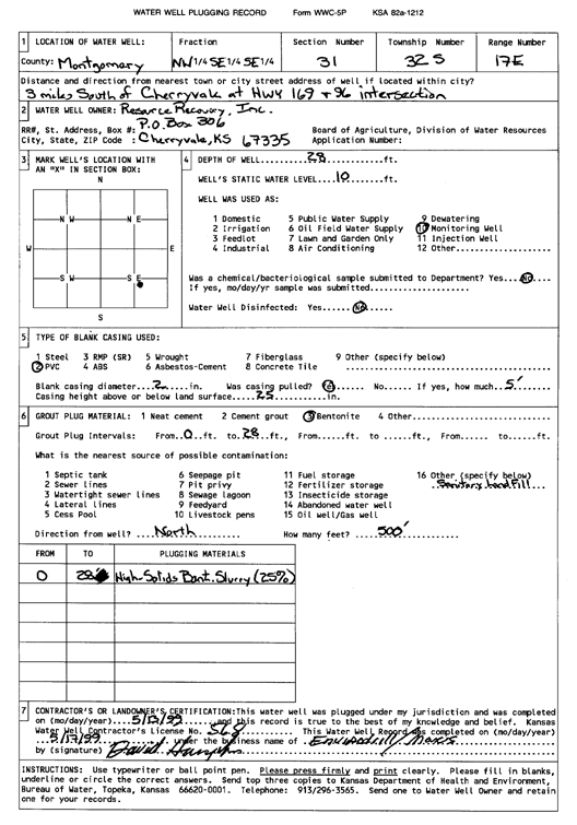
T32S, R17E, Sec. 31 NW SE SE |
Resource Recovery, Inc. | 28 ft. | 10 ft. | Monitoring well/observation/piezometer | Plugged | 13-May-1999 | Scan | ||
|
T32S, R17E, Sec. 31 SE NW NW |
Resource Recovery, Inc. | 85 ft. | Monitoring well/observation/piezometer | MW 4 | Constructed | 28-Apr-1993 | |||
|
T32S, R17E, Sec. 31 SE SE SW |
Resource Recovery, Inc. | 50 ft. | Monitoring well/observation/piezometer | MW 2 | Constructed | 28-Apr-1993 | |||
|
T32S, R17E, Sec. 31 SE SE SE |
Resource Recovery, Inc. | 34 ft. | Monitoring well/observation/piezometer | MW 7 | Constructed | 28-Apr-1993 | |||
|
T32S, R17E, Sec. 31 NE SW NE |
Resource Recovery, Inc. | 175 ft. | Monitoring well/observation/piezometer | MW 5 | Constructed | 26-Apr-1993 | |||
|
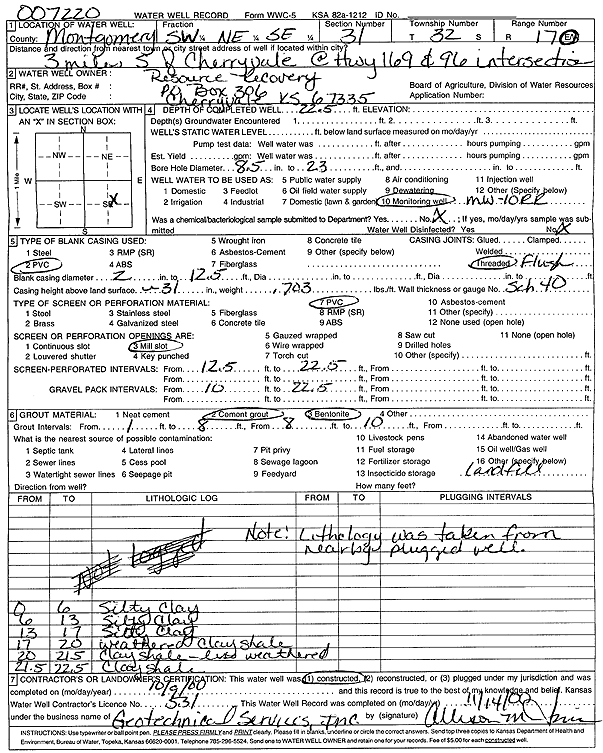
T32S, R17E, Sec. 31 SW NE SE |
Resource Recovery, Inc. | 22.5 ft. | Monitoring well/observation/piezometer | MW 10 RR | Constructed | 09-Oct-2000 | Scan | ||
|
T32S, R17E, Sec. 31 NE SW SE |
Resource Recovery, Inc. | 23.9 ft. | 6.6 ft. | Monitoring well/observation/piezometer | MW 3 | Constructed | 26-May-1998 | ||
|
T32S, R17E, Sec. 31 SW NW SE |
Resource Recovery, Inc. | 21.3 ft. | Monitoring well/observation/piezometer | MW 6 | Constructed | 27-May-1998 | |||
|
T32S, R17E, Sec. 32 NE NE NE |
Shepard, Tim C. | 70 ft. | 20 ft. | 12 gpm. | Domestic | Constructed | 20-Jul-1978 | ||
|
T33S, R13E, Sec. 24 SW SE NW |
Stark, Henry | 118 ft. | Domestic | Plugged | 15-Oct-1998 | Scan | |||
|
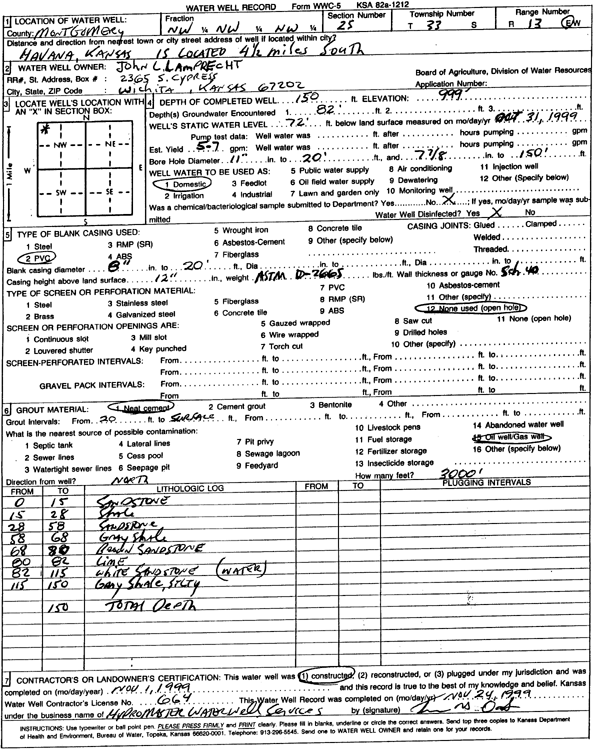
T33S, R13E, Sec. 25 NW NW NW |
Lamprecht, John L. | 150 ft. | 72 ft. | 6 gpm. | Domestic | Constructed | 01-Nov-1999 | Scan | |
|
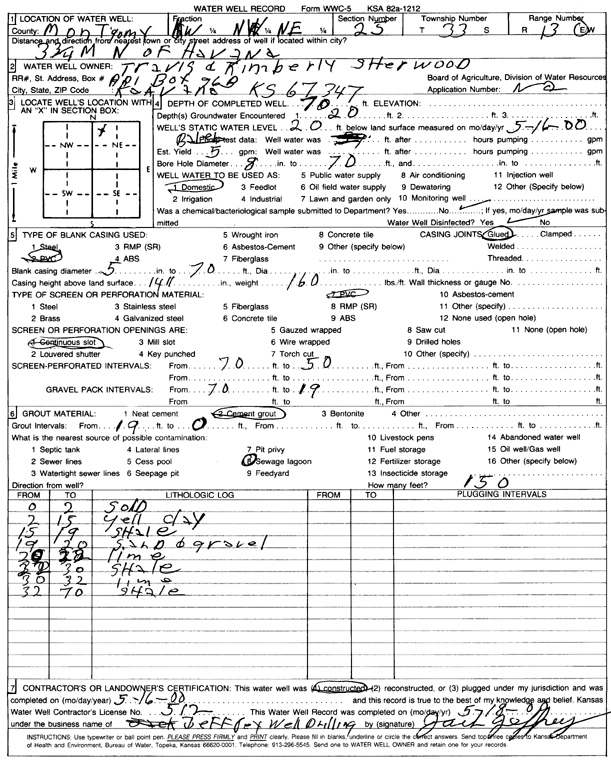
T33S, R13E, Sec. 25 NW NW NE |
Sherwood, Travis and Kimberly | 70 ft. | 20 ft. | 5 gpm. | Domestic | Constructed | 16-May-2000 | Scan | |
|
T33S, R14E, Sec. 2 NE NE SW |
Gingerich, Daniel | 110 ft. | 45 ft. | 15 gpm. | Domestic | Constructed | 12-Oct-2024 |
KOLAR |
|
|
T33S, R14E, Sec. 8 SW SW SW |
Whittum, Roger | 120 ft. | Domestic | Plugged | 06-Jun-1993 | ||||
|
T33S, R14E, Sec. 8 SW SW SW |
Whittum, Roger | 100 ft. | Domestic | Plugged | 25-May-1993 | ||||
|
T33S, R14E, Sec. 17 NE NW NE NW |
Daniels, Roger | 250 ft. | Geothermal, Closed Loop, Vertical | Constructed | 09-Jan-2017 |
KOLAR |
|||
|
T33S, R14E, Sec. 20 NE NE SW SE |
KCC | 20 ft. | Monitoring well/observation/piezometer | Mantooth 7 | Constructed | 30-Jan-2012 | |||
|
T33S, R14E, Sec. 20 NW SW SW SE |
KCC | 20 ft. | Monitoring well/observation/piezometer | Mantooth 10 | Constructed | 30-Jan-2012 | |||
|
T33S, R14E, Sec. 20 SW NW SE SE |
KCC | 20 ft. | Monitoring well/observation/piezometer | Mantooth 6 | Constructed | 31-Jan-2012 | |||
|
T33S, R14E, Sec. 20 NW NW SW SE |
KCC | 20 ft. | Monitoring well/observation/piezometer | Mantooth 8 | Constructed | 31-Jan-2012 | |||
|
T33S, R14E, Sec. 20 SW NE SW SE |
KCC | 20 ft. | Monitoring well/observation/piezometer | Mantooth 9 | Constructed | 30-Jan-2012 | |||
|
T33S, R14E, Sec. 27 SE NW SE NE |
Clubine, Levi | 140 ft. | 17 ft. | 20 gpm. | Domestic, Lawn and Garden | Constructed | 01-Sep-2021 |
KOLAR |
|
|
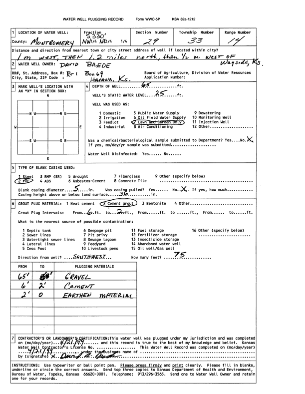
T33S, R14E, Sec. 29 NW NE |
Brede, David | 65 ft. | 25 ft. | Domestic, Lawn and Garden | Plugged | 21-Apr-1999 | Scan | ||
|
T33S, R14E, Sec. 29 NW NW NE NE |
KCC | 20 ft. | Monitoring well/observation/piezometer | Mantooth 5 | Constructed | 31-Jan-2012 | |||
|
T33S, R14E, Sec. 29 SW NW NE |
Mantooth, Guy | 145 ft. | 20 ft. | Domestic | Constructed | 06-Jan-1983 | |||
|
T33S, R14E, Sec. 30 SW NW NE |
Bush, Mike | 138 ft. | 14 ft. | .5 gpm. | Domestic | Constructed | 03-Jun-1996 | Scan | |
|
T33S, R14E, Sec. 30 NE NE SE |
Mason, Calvin | 150 ft. | 15.5 ft. | Domestic | Constructed | 02-May-1983 | |||
|
T33S, R14E, Sec. 30 SW NW NE |
100 ft. | 14 ft. | 5 gpm. | Domestic | Constructed | 09-Jun-1996 | Scan | ||
|
T33S, R15E, Sec. 1 SW SW NE |
Atherton, Floyd | 100 ft. | 8 ft. | 4 gpm. | Irrigation | Constructed | 24-Dec-1982 | ||
|
T33S, R15E, Sec. 1 SE SE NE |
Barta, Richard | 130 ft. | 10 ft. | Domestic | Plugged | 15-Jul-2014 | |||
|
T33S, R15E, Sec. 1 SW SW SE |
Musgrove, Carol | 125 ft. | 18 ft. | Domestic | Constructed | 27-Aug-1987 | |||
|
T33S, R15E, Sec. 8 SW NW SE |
Hutchison, William W. | 85 ft. | 18 ft. | Domestic | Constructed | 26-May-1978 | |||
|
T33S, R15E, Sec. 9 NE NW NE |
Bright, Wayne | 320 ft. | Geothermal, Closed Loop, Vertical | Constructed | 10-Jan-2011 | ||||
|
T33S, R15E, Sec. 11 SE NE NE |
Strecker, L. W. | 160 ft. | 15 ft. | 2 gpm. | Domestic | Constructed | 10-Sep-1996 | ||
|
T33S, R15E, Sec. 12 NE NE NE |
Crescent Oil Co Inc | 14 ft. | 11.25 ft. | Monitoring well/observation/piezometer | MW 9 | Constructed | 01-Dec-2009 | ||
|
T33S, R15E, Sec. 12 NE NE NE |
Crescent Oil Co Inc | 14 ft. | 5.2 ft. | Monitoring well/observation/piezometer | MW 5 | Constructed | 01-Dec-2009 | ||
|
T33S, R15E, Sec. 12 NE NE NE |
Crescent Oil Co Inc | 17 ft. | 2.62 ft. | Monitoring well/observation/piezometer | MW 2 | Constructed | 30-Nov-2009 | ||
|
T33S, R15E, Sec. 12 NE NE NE |
Crescent Oil Co Inc | 16.5 ft. | 6.87 ft. | Monitoring well/observation/piezometer | MW 6 | Constructed | 01-Dec-2009 | ||
|
T33S, R15E, Sec. 12 NE NE NE |
Crescent Oil Co Inc | 13.5 ft. | 8.16 ft. | Monitoring well/observation/piezometer | MW 8 | Constructed | 01-Dec-2009 | ||
|
T33S, R15E, Sec. 12 NE NE NE |
Crescent Oil Co Inc | 17 ft. | 3.58 ft. | Monitoring well/observation/piezometer | MW 3 | Constructed | 01-Dec-2009 | ||
|
T33S, R15E, Sec. 12 NE NE NE |
Crescent Oil Co Inc | 17 ft. | 6.47 ft. | Monitoring well/observation/piezometer | MW 4 | Constructed | 30-Nov-2009 | ||
|
T33S, R15E, Sec. 12 NE NE NE |
Crescent Oil Co Inc | 18 ft. | 8.25 ft. | Monitoring well/observation/piezometer | MW 7 | Constructed | 01-Dec-2009 | ||
|
T33S, R15E, Sec. 12 NE NE NE |
Crescent Oil Co Inc | 18 ft. | 4.27 ft. | Monitoring well/observation/piezometer | MW 1 | Constructed | 30-Nov-2009 | ||
|
T33S, R15E, Sec. 12 NE NE NE NE |
EPP Sunshine Acquisition, LLC | 18 ft. | 4.13 ft. | Monitoring well/observation/piezometer | MW 19 | Constructed | 24-Sep-2019 |
KOLAR |
|
|
T33S, R15E, Sec. 12 NE NE NE NE |
EPP Sunshine Acquisition, LLC | 18 ft. | 5.96 ft. | Monitoring well/observation/piezometer | MW 20 | Constructed | 24-Sep-2019 |
KOLAR |
|
|
T33S, R15E, Sec. 12 NE NE NE NE |
EPP Sunshine Acquisition, LLC | 18 ft. | 7.65 ft. | Monitoring well/observation/piezometer | MW 21 | Constructed | 24-Sep-2019 |
KOLAR |
|
|
T33S, R15E, Sec. 12 NE NE NE NE |
EPP Sunshine Acquisition, LLC | 18 ft. | 3.8 ft. | Monitoring well/observation/piezometer | MW 23 | Constructed | 24-Sep-2019 |
KOLAR |
|
|
T33S, R15E, Sec. 12 NE NE NE NE |
EPP Sunshine Acquisition, LLC | 20 ft. | 4.44 ft. | Monitoring well/observation/piezometer | MW 16 | Constructed | 23-Sep-2019 |
KOLAR |
|
|
T33S, R15E, Sec. 12 NE NE NE NE |
EPP Sunshine Acquisition, LLC | 18 ft. | 3.7 ft. | Monitoring well/observation/piezometer | MW 17 | Constructed | 23-Sep-2019 |
KOLAR |
|
| View page: < Prev || 11 || 12 || 13 || 14 || 15 || 16 || 17 || 18 || 19 || 20 || Next > | |||||||||