Select location of well to view details.
Click on column heading to sort.
|
|
|
County: Brown Select location of well to view details. Click on column heading to sort. |
|
|
|
| View page: < Prev || 11 || 12 || 13 || 14 || 15 || 16 || 17 || 18 || 19 || 20 || Next > | |||||||||
| T-R-S | Owner | Well Depth Ascend. Desc. |
Static Water Level Ascend. Desc. |
Est. Yield Ascend. Desc. |
Well Use | Other ID | Action Taken | Completion Date Ascend. Desc. |
Scan? |
|
T2S, R17E, Sec. 29 SE NW NE |
City of Hiawatha | 40 ft. | 9.7 ft. | Monitoring well/observation/piezometer | MW 3 | Constructed | 26-Jul-1994 | ||
|
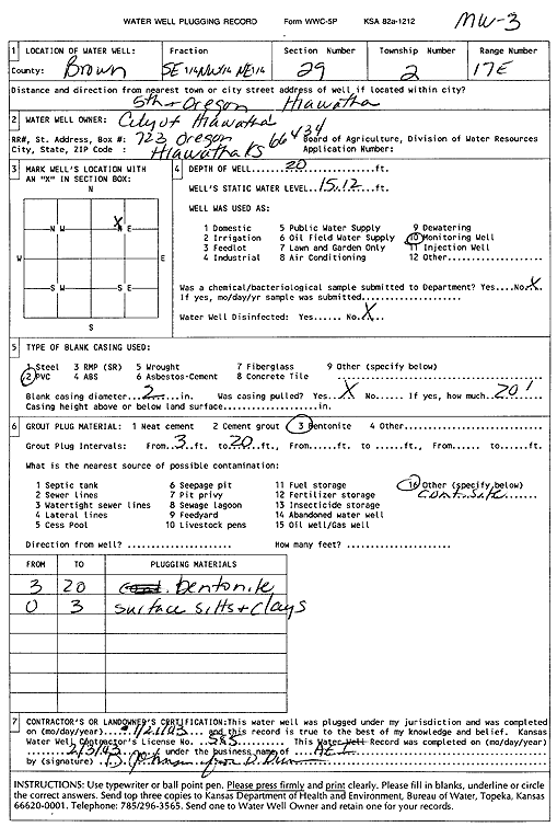
T2S, R17E, Sec. 29 SE NW NE |
City of Hiawatha | 20 ft. | 15.12 ft. | Monitoring well/observation/piezometer | MW 3 | Plugged | 21-Jan-2003 | Scan | |
|
T2S, R17E, Sec. 29 NW SE NE |
City of Hiawatha | 35 ft. | 4.91 ft. | Monitoring well/observation/piezometer | MW 1 | Constructed | 26-Jul-1994 | ||
|
T2S, R17E, Sec. 29 C SE |
Flair Fold Corp. | 12.2 ft. | 4.77 ft. | Monitoring well/observation/piezometer | FSMW 2 | Constructed | 19-May-1995 | ||
|
T2S, R17E, Sec. 29 C SE |
Flair Fold Corp. | 35.4 ft. | 18.03 ft. | Monitoring well/observation/piezometer | FSMW 7 | Constructed | 23-May-1995 | ||
|
T2S, R17E, Sec. 29 C SE |
Flair Fold Corp. | 13.5 ft. | 4.38 ft. | Monitoring well/observation/piezometer | FSMW 3 | Constructed | 17-May-1995 | ||
|
T2S, R17E, Sec. 29 C SE |
Flair Fold Corp. | 19.5 ft. | 2.05 ft. | Monitoring well/observation/piezometer | FSMW 1 | Constructed | 17-May-1995 | ||
|
T2S, R17E, Sec. 29 C SE |
Flair Fold Corp. | 13.8 ft. | 2.17 ft. | Monitoring well/observation/piezometer | FSMW 6 | Constructed | 20-May-1995 | ||
|
T2S, R17E, Sec. 29 C SE |
Flair Fold Corp. | 13 ft. | 3.53 ft. | Monitoring well/observation/piezometer | FSMW 4 | Constructed | 18-May-1995 | ||
|
T2S, R17E, Sec. 29 C SE |
Flair Fold Corp. | 14.5 ft. | 4.69 ft. | Monitoring well/observation/piezometer | FSMW 5 | Constructed | 20-May-1995 | ||
|
T2S, R17E, Sec. 29 SW SE NE NW |
HDH, LLC | 200 ft. | Geothermal, Closed Loop, Vertical | Constructed | 30-Mar-2017 |
KOLAR |
|||
|
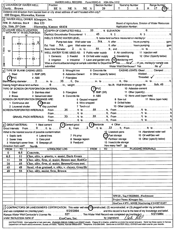
T2S, R17E, Sec. 29 SE NE NE |
Kloepper, Inc. | 55 ft. | Monitoring well/observation/piezometer | MW 2R | Constructed | 25-May-2004 | Scan | ||
|
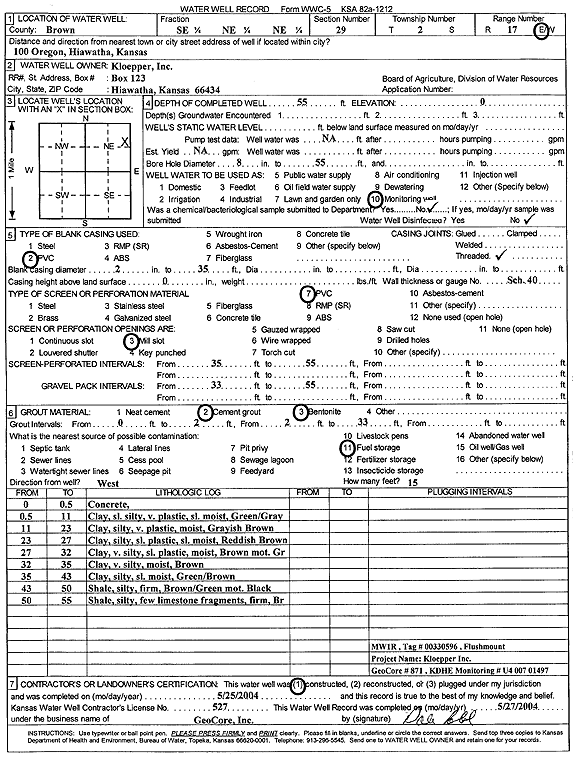
T2S, R17E, Sec. 29 SE NE NE |
Kloepper, Inc. | 55 ft. | Monitoring well/observation/piezometer | MW 1R | Constructed | 25-May-2004 | Scan | ||
|
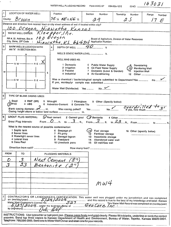
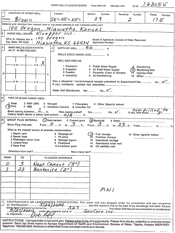
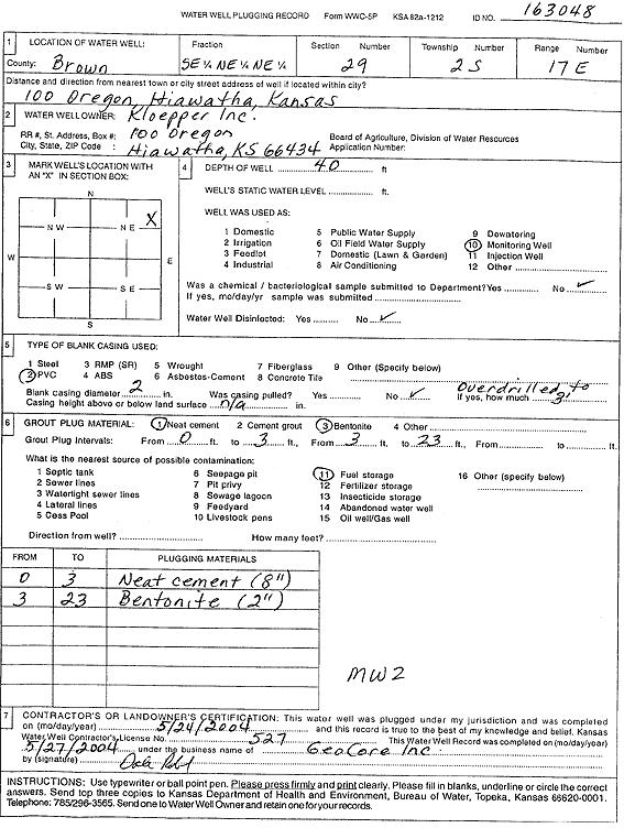
T2S, R17E, Sec. 29 SE NE NE |
Kloepper, Inc. | 40 ft. | Monitoring well/observation/piezometer | MW 4 | Plugged | 24-May-2004 | Scan | ||
|
T2S, R17E, Sec. 29 SE NE NE |
Kloepper, Inc. | 40 ft. | 39.6 ft. | Monitoring well/observation/piezometer | MW 3 | Constructed | 27-Mar-1997 | ||
|
T2S, R17E, Sec. 29 SE NE NE |
Kloepper, Inc. | 40 ft. | 33.4 ft. | Monitoring well/observation/piezometer | MW 4 | Constructed | 27-Mar-1997 | ||
|
T2S, R17E, Sec. 29 SE NE NE |
Kloepper, Inc. | 40 ft. | 33.35 ft. | Monitoring well/observation/piezometer | MW 2 | Constructed | 26-Mar-1997 | ||
|
T2S, R17E, Sec. 29 SE NE NE |
Kloepper, Inc. | 40 ft. | 34.93 ft. | Monitoring well/observation/piezometer | MW 1 | Constructed | 26-Mar-1997 | ||
|
T2S, R17E, Sec. 29 SE NE NE |
Kloepper, Inc. | 60 ft. | Monitoring well/observation/piezometer | MW 2 R 2 | Constructed | 21-Oct-2009 | |||
|
T2S, R17E, Sec. 29 SE NE NE |
Kloepper, Inc. | 60 ft. | Monitoring well/observation/piezometer | MW 3 R | Constructed | 22-Oct-2009 | |||
|
T2S, R17E, Sec. 29 SE NE NE |
Kloepper, Inc. | 55 ft. | Monitoring well/observation/piezometer | MW 4R | Constructed | 24-May-2004 | Scan | ||
|
T2S, R17E, Sec. 29 SE NE NE |
Kloepper, Inc. | 56 ft. | 49.4 ft. | Monitoring well/observation/piezometer | MW 2R | Plugged | 21-Dec-2005 | ||
|
T2S, R17E, Sec. 29 SE NE NE |
Kloepper, Inc. | 56 ft. | Monitoring well/observation/piezometer | MW 3 | Plugged | 21-Dec-2005 | |||
|
T2S, R17E, Sec. 29 SE NE NE |
Kloepper, Inc. | 56 ft. | 42.81 ft. | Monitoring well/observation/piezometer | MW 1R | Plugged | 21-Dec-2005 | ||
|
T2S, R17E, Sec. 29 SE NE NE |
Kloepper, Inc. | 21.19 ft. | Monitoring well/observation/piezometer | MW 1 R 2 | Plugged | 07-Jan-2014 | |||
|
T2S, R17E, Sec. 29 SE NE NE |
Kloepper, Inc. | 40 ft. | Monitoring well/observation/piezometer | MW 1 | Plugged | 24-May-2004 | Scan | ||
|
T2S, R17E, Sec. 29 SE NE NE |
Kloepper, Inc. | 60 ft. | 52.87 ft. | Monitoring well/observation/piezometer | MW 1 R 3 | Constructed | 07-Jan-2014 | ||
|
T2S, R17E, Sec. 29 SE NE NE |
Kloepper, Inc. | 40 ft. | Monitoring well/observation/piezometer | MW 2 | Plugged | 24-May-2004 | Scan | ||
|
T2S, R17E, Sec. 29 SE NE NE |
Kloepper, Inc. | 60 ft. | Monitoring well/observation/piezometer | MW 9 | Constructed | 21-Oct-2009 | |||
|
T2S, R17E, Sec. 29 SE NE NE |
Kloepper, Inc. | 60 ft. | Monitoring well/observation/piezometer | MW 1 R 2 | Constructed | 20-Oct-2009 | |||
|
T2S, R17E, Sec. 29 SE SE NE NE |
Kloepper, Inc. | 55.06 ft. | 45.37 ft. | Monitoring well/observation/piezometer | MW 4 R | Plugged | 14-Jul-2017 | ||
|
T2S, R17E, Sec. 29 NE NE NE |
Scheid, Ramona | 20 ft. | 5.41 ft. | Monitoring well/observation/piezometer | MW 6 | Plugged | 01-Mar-2005 | ||
|
T2S, R17E, Sec. 29 NE NE SE |
Scheid, Ramona | 40 ft. | 31.2 ft. | Monitoring well/observation/piezometer | MW 4 | Plugged | 01-Mar-2005 | ||
|
T2S, R17E, Sec. 29 NE NE SE |
Scheid, Ramona | 45 ft. | 32.25 ft. | Monitoring well/observation/piezometer | MW 2 | Constructed | 05-Jul-1994 | ||
|
T2S, R17E, Sec. 29 NE NE NE |
Scheid, Ramona | 45 ft. | 32.3 ft. | Monitoring well/observation/piezometer | MW 2 | Plugged | 01-Mar-2005 | ||
|
T2S, R17E, Sec. 29 NE NE SE |
Scheid, Ramona | 15.5 ft. | 14.25 ft. | Monitoring well/observation/piezometer | MW 1 | Constructed | 05-Jul-1994 | ||
|
T2S, R17E, Sec. 29 NE NE NE |
Scheid, Ramona | 20 ft. | 5.41 ft. | Monitoring well/observation/piezometer | MW 6 | Constructed | 19-Oct-2004 | ||
|
T2S, R17E, Sec. 29 NE NE NE |
Scheid, Ramona | 15.6 ft. | 14.3 ft. | Monitoring well/observation/piezometer | MW 1 | Plugged | 01-Mar-2005 | ||
|
T2S, R17E, Sec. 29 NE NE SE |
Scheid, Ramona | 40 ft. | 31.2 ft. | Monitoring well/observation/piezometer | MW 4 | Constructed | 06-Jul-1994 | ||
|
T2S, R17E, Sec. 29 SE NW NW |
Shear, Roger/Shear Auto | 15 ft. | 7.13 ft. | Monitoring well/observation/piezometer | Constructed | 01-May-2008 | |||
|
T2S, R17E, Sec. 29 SE NW NW |
Shear, Roger/Shear Auto | 15 ft. | 6.75 ft. | Monitoring well/observation/piezometer | Constructed | 01-May-2008 | |||
|
T2S, R17E, Sec. 29 NE NE NE |
Stop 2 Shop | 18 ft. | 15 ft. | Monitoring well/observation/piezometer | MW 7 | Constructed | 30-Jul-1996 | ||
|
T2S, R17E, Sec. 30 NE SE SE |
Ag Partners Coop Inc. | 200 ft. | Geothermal, Closed Loop, Vertical | Constructed | 07-Jul-2022 |
KOLAR |
|||
|
T2S, R17E, Sec. 30 C NE |
Flair Fold Corp. | 12.4 ft. | 5.88 ft. | Monitoring well/observation/piezometer | IAMW 4 | Constructed | 18-May-1995 | ||
|
T2S, R17E, Sec. 30 C NE |
Flair Fold Corp. | 23.8 ft. | 12.21 ft. | Monitoring well/observation/piezometer | IAMW 5 | Constructed | 19-May-1995 | ||
|
T2S, R17E, Sec. 30 C NE |
Flair Fold Corp. | 36 ft. | 31.7 ft. | Monitoring well/observation/piezometer | IAMW 3 | Constructed | 17-May-1995 | ||
|
T2S, R17E, Sec. 30 C NE |
Flair Fold Corp. | 55.2 ft. | 6.91 ft. | Monitoring well/observation/piezometer | IAMW 8 | Constructed | 22-May-1995 | ||
|
T2S, R17E, Sec. 30 C NE |
Flair Fold Corp. | 55.4 ft. | 40.81 ft. | Monitoring well/observation/piezometer | IAMW 6 | Constructed | 22-May-1995 | ||
|
T2S, R17E, Sec. 30 C NE |
Flair Fold Corp. | 13.3 ft. | 4.75 ft. | Monitoring well/observation/piezometer | IAMW 9 | Constructed | 23-May-1995 | ||
|
T2S, R17E, Sec. 30 C NE |
Flair Fold Corp. | 12.7 ft. | 6.59 ft. | Monitoring well/observation/piezometer | IAMW 2 | Constructed | 18-May-1995 | ||
| View page: < Prev || 11 || 12 || 13 || 14 || 15 || 16 || 17 || 18 || 19 || 20 || Next > | |||||||||