Select location of well to view details.
Click on column heading to sort.
|
|
|
County: Brown Select location of well to view details. Click on column heading to sort. |
|
|
|
| View page: < Prev || 11 || 12 || 13 || 14 || 15 || 16 || 17 || 18 || 19 || 20 || Next > | |||||||||
| T-R-S | Owner | Well Depth Ascend. Desc. |
Static Water Level Ascend. Desc. |
Est. Yield Ascend. Desc. |
Well Use | Other ID | Action Taken | Completion Date Ascend. Desc. |
Scan? |
|
T4S, R17E, Sec. 12 SE NE NW NE |
Engle, Jerry | 320 ft. | 220 ft. | 30 gpm. | Domestic, Livestock | Constructed | 17-Oct-2012 |
KOLAR |
|
|
T4S, R17E, Sec. 17 NW SE NW |
Chartier, Steve | 49 ft. | 6 ft. | 1 gpm. | Domestic, Livestock | Constructed | 09-Aug-2025 |
KOLAR |
|
|
T4S, R17E, Sec. 17 NW SW SW NW |
Chartier, Steve | 67.33 ft. | 14 ft. | 5 gpm. | Domestic, Livestock | Constructed | 15-Aug-2019 | ||
|
T4S, R17E, Sec. 21 SE SW SE |
Horton Lakeview Country Club | 30 ft. | 19 ft. | Public Water Supply | Reconstructed | 11-Apr-1980 | |||
|
T4S, R17E, Sec. 21 NE NE SE |
Knudson | 100 ft. | 21 ft. | 1 gpm. | Domestic | Constructed | 24-Feb-1977 | ||
|
T4S, R17E, Sec. 21 C SW NE |
Stephens, Ortho | 100 ft. | 19 ft. | .5 gpm. | Domestic | Constructed | 08-Dec-1976 | ||
|
T4S, R17E, Sec. 24 SE SW SW |
Bryan, Gary | 100 ft. | 21 ft. | 1 gpm. | Domestic, Livestock | Constructed | 15-Nov-2016 | ||
|
T4S, R17E, Sec. 24 NE SE SE |
Bunck, Mike | 97 ft. | 52 ft. | Domestic | WW 730 | Constructed | 02-Sep-2004 | ||
|
T4S, R17E, Sec. 24 SW SW SE SE |
U.S. Geological Survey | 28.6 ft. | Monitoring well/observation/piezometer | Constructed | 03-Oct-2010 | ||||
|
T4S, R17E, Sec. 26 SE NW NE |
Bryan, Charles | 58 ft. | 9 ft. | 1 gpm. | Domestic | Constructed | 08-May-1990 | ||
|
T4S, R17E, Sec. 26 NW SW SW |
Small, I.A. | 140 ft. | 30 ft. | 1.5 gpm. | Domestic | Constructed | 14-Jan-1980 | ||
|
T4S, R17E, Sec. 28 SW NW SW |
Brown-Atchison REC | 26.5 ft. | 22.71 ft. | Monitoring well/observation/piezometer | MW 2 | Constructed | 07-Nov-1994 | ||
|
T4S, R17E, Sec. 28 SW NW SW |
Brown-Atchison REC | 25 ft. | 19.95 ft. | Monitoring well/observation/piezometer | MW 4 | Constructed | 08-Nov-1994 | ||
|
T4S, R17E, Sec. 28 SW NW SW |
Brown-Atchison REC | 27 ft. | 23.21 ft. | Monitoring well/observation/piezometer | MW 6 | Constructed | 09-Nov-1994 | ||
|
T4S, R17E, Sec. 28 SW NW SW |
Brown-Atchison REC | 25 ft. | 23.02 ft. | Monitoring well/observation/piezometer | MW 7 | Constructed | 10-Nov-1994 | ||
|
T4S, R17E, Sec. 28 SW NW SW |
Brown-Atchison REC | 22 ft. | 18.94 ft. | Monitoring well/observation/piezometer | MW 10 | Constructed | 22-Nov-1994 | ||
|
T4S, R17E, Sec. 28 SW NW SW |
Brown-Atchison REC | 23.7 ft. | 20.28 ft. | Monitoring well/observation/piezometer | MW 1 | Constructed | 07-Nov-1994 | ||
|
T4S, R17E, Sec. 28 SW NW SW |
Brown-Atchison REC | 30 ft. | 22.12 ft. | Monitoring well/observation/piezometer | MW 3 | Constructed | 08-Nov-1994 | ||
|
T4S, R17E, Sec. 28 SW NW SW |
Brown-Atchison REC | 27 ft. | 20.1 ft. | Monitoring well/observation/piezometer | MW 5 | Constructed | 09-Nov-1994 | ||
|
T4S, R17E, Sec. 28 SW NW SW |
Brown-Atchison REC | 23.5 ft. | 18.11 ft. | Monitoring well/observation/piezometer | MW 9 | Constructed | 21-Nov-1994 | ||
|
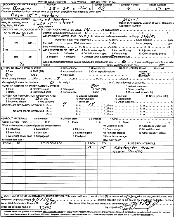
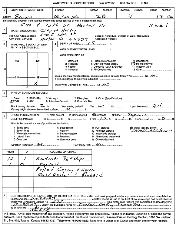
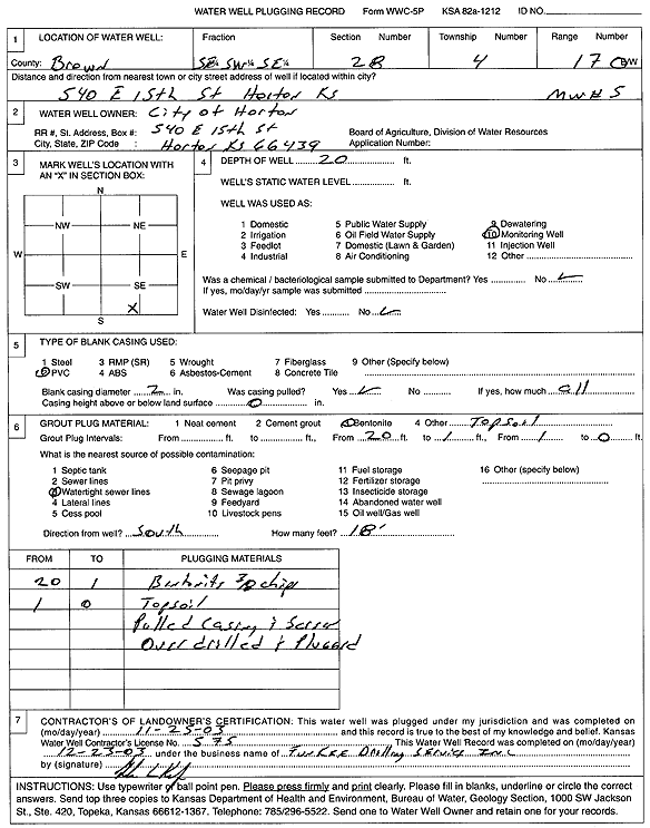
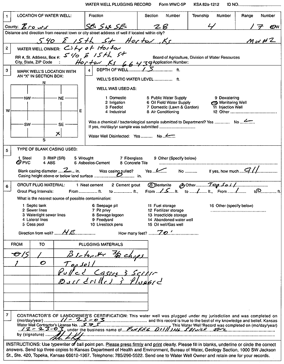
T4S, R17E, Sec. 28 SE SE SW |
City of Horton | 14 ft. | 4.21 ft. | Monitoring well/observation/piezometer | MW 1 | Plugged | 22-Apr-2003 | Scan | |
|
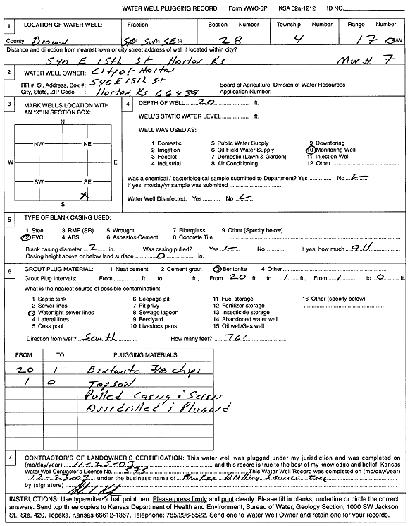
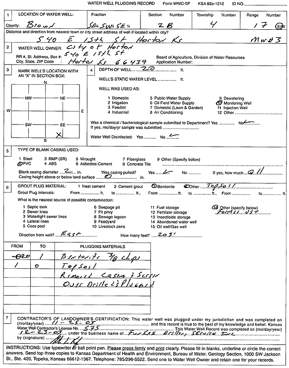
T4S, R17E, Sec. 28 SE SW SE |
City of Horton | 20 ft. | Monitoring well/observation/piezometer | MW 7 | Plugged | 25-Nov-2003 | Scan | ||
|
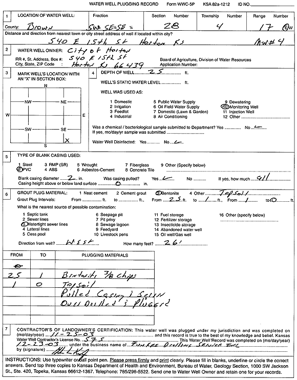
T4S, R17E, Sec. 28 SW SE SE |
City of Horton | 25 ft. | Monitoring well/observation/piezometer | MW 4 | Plugged | 25-Nov-2003 | Scan | ||
|
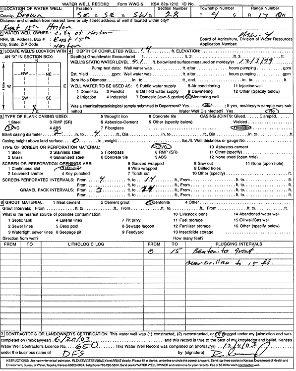
T4S, R17E, Sec. 28 SW NW SW |
City of Horton | 23.5 ft. | 12.48 ft. | Monitoring well/observation/piezometer | MW 14 | Constructed | 27-Apr-1995 | ||
|
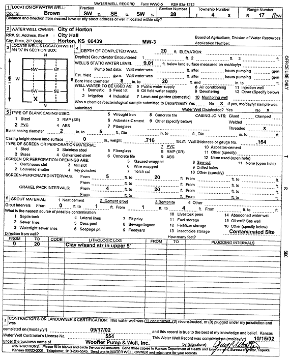
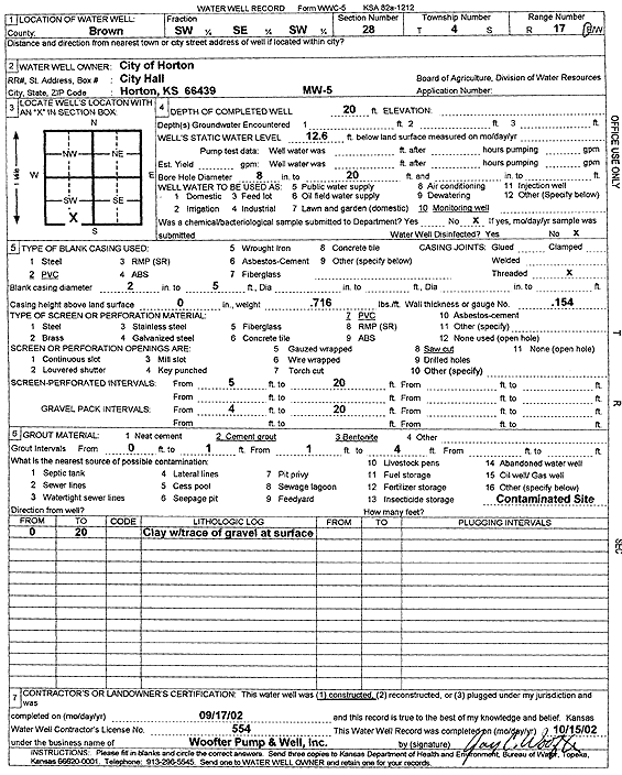
T4S, R17E, Sec. 28 SW SE SW |
City of Horton | 20 ft. | 9.01 ft. | Monitoring well/observation/piezometer | MW 3 | Constructed | 17-Sep-2002 | Scan | |
|
T4S, R17E, Sec. 28 SE SE SW |
City of Horton | 14 ft. | 4.1 ft. | Monitoring well/observation/piezometer | MW 4 | Plugged | 20-Jun-2003 | Scan | |
|
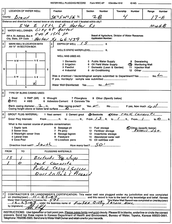
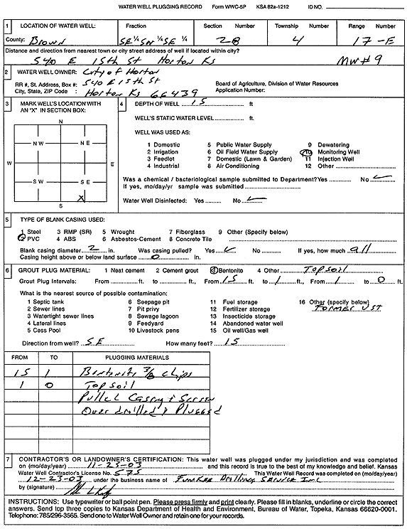
T4S, R17E, Sec. 28 SE SW SE |
City of Horton | 20 ft. | Monitoring well/observation/piezometer | MW 3 | Plugged | 25-Nov-2003 | Scan | ||
|
T4S, R17E, Sec. 28 SE SW SE |
City of Horton | 15 ft. | Monitoring well/observation/piezometer | MW 8 | Plugged | 25-Nov-2003 | Scan | ||
|
T4S, R17E, Sec. 28 SE SW SE |
City of Horton | 15 ft. | Monitoring well/observation/piezometer | MW 9 | Plugged | 25-Nov-2003 | Scan | ||
|
T4S, R17E, Sec. 28 SE SE SW |
City of Horton | 13 ft. | 3.68 ft. | Monitoring well/observation/piezometer | MW 4 | Constructed | 03-Dec-1997 | ||
|
T4S, R17E, Sec. 28 SE SE SW |
City of Horton | 17 ft. | 8.59 ft. | Monitoring well/observation/piezometer | MW 5 | Constructed | 03-Dec-1997 | ||
|
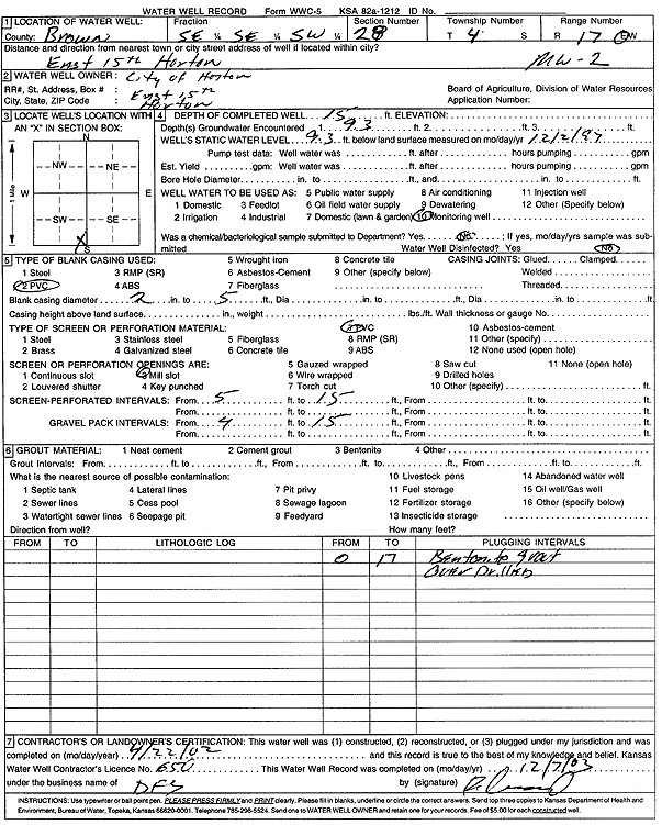
T4S, R17E, Sec. 28 SE SE SW |
City of Horton | 15 ft. | 9.3 ft. | Monitoring well/observation/piezometer | MW 2 | Constructed | 03-Dec-1997 | ||
|
T4S, R17E, Sec. 28 SE SE SW |
City of Horton | 15 ft. | 3.5 ft. | Monitoring well/observation/piezometer | MW 3 | Constructed | 03-Dec-1997 | ||
|
T4S, R17E, Sec. 28 SE SE SW |
City of Horton | 9 ft. | Monitoring well/observation/piezometer | MW 7 | Constructed | 03-Dec-1997 | |||
|
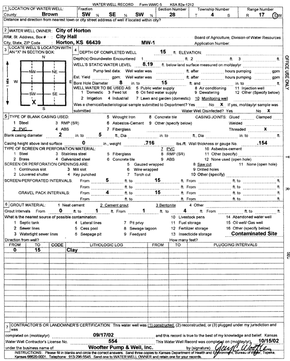
T4S, R17E, Sec. 28 SW SE SW |
City of Horton | 15 ft. | 8.19 ft. | Monitoring well/observation/piezometer | MW 1 | Constructed | 17-Sep-2002 | Scan | |
|
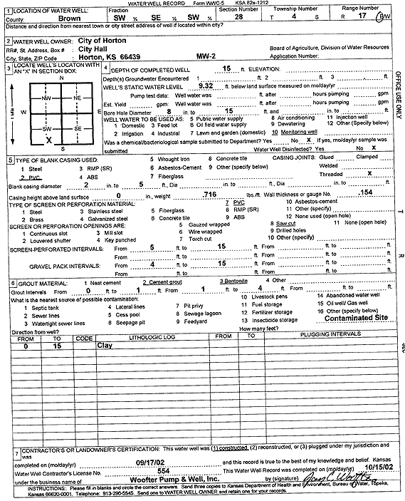
T4S, R17E, Sec. 28 SW SE SW |
City of Horton | 15 ft. | 9.32 ft. | Monitoring well/observation/piezometer | MW 2 | Constructed | 17-Sep-2002 | Scan | |
|
T4S, R17E, Sec. 28 SW NW SW |
City of Horton | 18.25 ft. | 6.86 ft. | Monitoring well/observation/piezometer | MW 15 | Constructed | 27-Apr-1995 | ||
|
T4S, R17E, Sec. 28 SW NW SW |
City of Horton | 24 ft. | 10.47 ft. | Monitoring well/observation/piezometer | MW 12 | Constructed | 27-Apr-1995 | ||
|
T4S, R17E, Sec. 28 SE SW SE |
City of Horton | 15 ft. | Monitoring well/observation/piezometer | MW 1 | Plugged | 25-Nov-2003 | Scan | ||
|
T4S, R17E, Sec. 28 SE SE SW |
City of Horton | 15 ft. | 9.3 ft. | Monitoring well/observation/piezometer | MW 2 | Plugged | 22-Apr-2003 | Scan | |
|
T4S, R17E, Sec. 28 SE SW SE |
City of Horton | 20 ft. | Monitoring well/observation/piezometer | MW 5 | Plugged | 25-Nov-2003 | Scan | ||
|
T4S, R17E, Sec. 28 SE SW SE |
City of Horton | 15 ft. | Monitoring well/observation/piezometer | MW 2 | Plugged | 25-Nov-2003 | Scan | ||
|
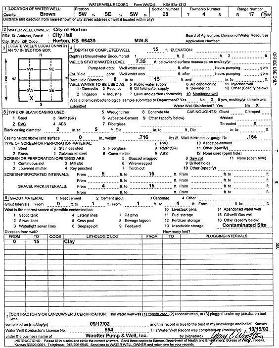
T4S, R17E, Sec. 28 SW SE SW |
City of Horton | 15 ft. | 7.35 ft. | Monitoring well/observation/piezometer | MW 8 | Constructed | 17-Sep-2002 | Scan | |
|
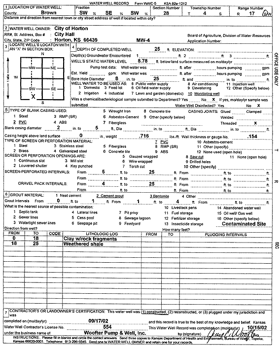
T4S, R17E, Sec. 28 SW SE SW |
City of Horton | 25 ft. | 8.78 ft. | Monitoring well/observation/piezometer | MW 4 | Constructed | 17-Sep-2002 | Scan | |
|
T4S, R17E, Sec. 28 SW NW SW |
City of Horton | 24 ft. | 16.84 ft. | Monitoring well/observation/piezometer | MW 11 | Constructed | 27-Apr-1995 | ||
|
T4S, R17E, Sec. 28 SW SE SW |
City of Horton | 20 ft. | 12.6 ft. | Monitoring well/observation/piezometer | MW 5 | Constructed | 17-Sep-2002 | Scan | |
|
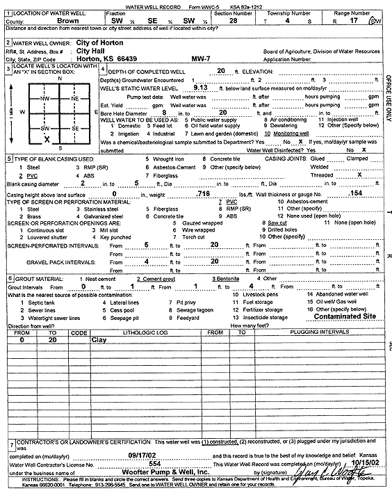
T4S, R17E, Sec. 28 SW SE SW |
City of Horton | 20 ft. | 9.13 ft. | Monitoring well/observation/piezometer | MW 7 | Constructed | 17-Sep-2002 | Scan | |
|
T4S, R17E, Sec. 28 SW SE SW |
City of Horton | 15 ft. | 8.1 ft. | Monitoring well/observation/piezometer | MW 9 | Constructed | 17-Sep-2002 | Scan | |
|
T4S, R17E, Sec. 28 NE NE SE |
Earlywine, Lewis | 150 ft. | 45.25 ft. | 15 gpm. | Domestic | Constructed | 18-Jul-1977 | ||
|
T4S, R17E, Sec. 28 NE SE NE |
Gasper, Carl | 81 ft. | 22 ft. | 2 gpm. | Domestic, Lawn and Garden | Constructed | 22-Aug-2005 | ||
| View page: < Prev || 11 || 12 || 13 || 14 || 15 || 16 || 17 || 18 || 19 || 20 || Next > | |||||||||