Select location of well to view details.
Click on column heading to sort.
|
|
|
County: Brown Select location of well to view details. Click on column heading to sort. |
|
|
|
| View page: < Prev || 21 || 22 || 23 | |||||||||
| T-R-S | Owner | Well Depth Ascend. Desc. |
Static Water Level Ascend. Desc. |
Est. Yield Ascend. Desc. |
Well Use | Other ID | Action Taken | Completion Date Ascend. Desc. |
Scan? |
|
T4S, R17E, Sec. 28 SW SW SW |
KDHE | 20.12 ft. | Monitoring well/observation/piezometer | MW 4 | Plugged | 16-Nov-2012 | |||
|
T4S, R17E, Sec. 28 SW SW SW |
KDHE | 20.34 ft. | Monitoring well/observation/piezometer | MW 3 | Plugged | 16-Nov-2012 | |||
|
T4S, R17E, Sec. 28 SW SW SW |
KDHE | 18.37 ft. | Monitoring well/observation/piezometer | MW 2 | Plugged | 16-Nov-2012 | |||
|
T4S, R17E, Sec. 28 SW SW SW |
KDHE | 18.31 ft. | Monitoring well/observation/piezometer | MW 8 | Plugged | 16-Nov-2012 | |||
|
T4S, R17E, Sec. 28 SW SW SW |
KDHE | 20 ft. | 6.45 ft. | Monitoring well/observation/piezometer | MW 3 | Constructed | 19-Sep-2011 | ||
|
T4S, R17E, Sec. 28 SW SW SW |
KDHE | 18 ft. | 3.8 ft. | Monitoring well/observation/piezometer | MW 2 | Constructed | 19-Sep-2011 | ||
|
T4S, R17E, Sec. 28 SW SW SW |
KDHE | 19.5 ft. | 4.3 ft. | Monitoring well/observation/piezometer | MW 5 | Constructed | 19-Sep-2011 | ||
|
T4S, R17E, Sec. 28 SW SW SW |
KDHE | 19 ft. | 3.91 ft. | Monitoring well/observation/piezometer | MW 6 | Reconstructed | 19-Sep-2011 | ||
|
T4S, R17E, Sec. 28 SW SW SW |
KDHE | 20 ft. | 4.8 ft. | Monitoring well/observation/piezometer | MW 1 | Constructed | 19-Sep-2011 | ||
|
T4S, R17E, Sec. 28 SW SW SW |
KDHE | 20 ft. | 6.15 ft. | Monitoring well/observation/piezometer | MW 4 | Constructed | 19-Sep-2011 | ||
|
T4S, R17E, Sec. 28 SW SW SW |
KDHE | 20.04 ft. | Monitoring well/observation/piezometer | MW 1 | Plugged | 16-Nov-2012 | |||
|
T4S, R17E, Sec. 28 SW SW SW |
KDHE | 19.52 ft. | Monitoring well/observation/piezometer | MW 5 | Plugged | 16-Nov-2012 | |||
|
T4S, R17E, Sec. 28 SW SW SW |
KDHE | 20.75 ft. | Monitoring well/observation/piezometer | MW 7 | Plugged | 16-Nov-2012 | |||
|
T4S, R17E, Sec. 28 SW SW SW |
KDHE | 19.13 ft. | Monitoring well/observation/piezometer | MW 6 | Plugged | 16-Nov-2012 | |||
|
T4S, R17E, Sec. 28 SE NW SW SW |
KDOT | 18 ft. | 3.42 ft. | Monitoring well/observation/piezometer | MW 9 | Constructed | 24-Nov-2009 | ||
|
T4S, R17E, Sec. 28 NW SW SW |
KDOT | 30 ft. | 8 ft. | Monitoring well/observation/piezometer | MW 4 | Constructed | 25-Mar-1997 | ||
|
T4S, R17E, Sec. 28 NW SW SW |
KDOT | 20 ft. | 6.8 ft. | Monitoring well/observation/piezometer | MW 5 | Constructed | 25-Mar-1997 | ||
|
T4S, R17E, Sec. 28 NW SW SW |
KDOT | 30 ft. | 8.4 ft. | Monitoring well/observation/piezometer | MW 1 | Constructed | 24-Mar-1997 | ||
|
T4S, R17E, Sec. 28 NW SW SW |
KDOT | 29.5 ft. | Monitoring well/observation/piezometer | MW 3 | Plugged | 20-Oct-2010 | |||
|
T4S, R17E, Sec. 28 NW SW SW |
KDOT | 29.4 ft. | Monitoring well/observation/piezometer | MW 1 | Plugged | 20-Oct-2010 | |||
|
T4S, R17E, Sec. 28 NE SW SW |
KDOT | 17.8 ft. | Monitoring well/observation/piezometer | MW 11 | Plugged | 20-Oct-2010 | |||
|
T4S, R17E, Sec. 28 SW NE SW SW |
KDOT | 18 ft. | 12.4 ft. | Monitoring well/observation/piezometer | MW 11 | Constructed | 24-Nov-2009 | ||
|
T4S, R17E, Sec. 28 NW SW SW |
KDOT | 30 ft. | 4.9 ft. | Monitoring well/observation/piezometer | MW 3 | Constructed | 24-Mar-1997 | ||
|
T4S, R17E, Sec. 28 NW SW SW |
KDOT | 30 ft. | 11.4 ft. | Monitoring well/observation/piezometer | MW 2 | Constructed | 24-Mar-1997 | ||
|
T4S, R17E, Sec. 28 NW SW SW |
KDOT | 20 ft. | 3.39 ft. | Monitoring well/observation/piezometer | MW 7 | Constructed | 14-May-2009 | ||
|
T4S, R17E, Sec. 28 NW SW SW |
KDOT | 19 ft. | Monitoring well/observation/piezometer | MW 6 | Plugged | 20-Oct-2010 | |||
|
T4S, R17E, Sec. 28 NW SW SW |
KDOT | 19.35 ft. | Monitoring well/observation/piezometer | MW 5 | Plugged | 20-Oct-2010 | |||
|
T4S, R17E, Sec. 28 SE NW SW SW |
KDOT | 18 ft. | 7.37 ft. | Monitoring well/observation/piezometer | MW 10 | Constructed | 24-Nov-2009 | ||
|
T4S, R17E, Sec. 28 NW SW SW |
KDOT | 20 ft. | 6.4 ft. | Monitoring well/observation/piezometer | MW 6 | Constructed | 25-Mar-1997 | ||
|
T4S, R17E, Sec. 28 NW SW SW |
KDOT | 16.8 ft. | Monitoring well/observation/piezometer | MW 9 | Plugged | 20-Oct-2010 | |||
|
T4S, R17E, Sec. 28 NW SW SW |
KDOT | 17.57 ft. | Monitoring well/observation/piezometer | MW 10 | Plugged | 20-Oct-2010 | |||
|
T4S, R17E, Sec. 28 NE SW SW |
KDOT | 20 ft. | 9.19 ft. | Monitoring well/observation/piezometer | MW 8 | Constructed | 14-May-2009 | ||
|
T4S, R17E, Sec. 28 NW SW SW |
KDOT | 29.45 ft. | Monitoring well/observation/piezometer | MW 4 | Plugged | 20-Oct-2010 | |||
|
T4S, R17E, Sec. 28 NW SW SW |
KDOT | 19.7 ft. | Monitoring well/observation/piezometer | MW 7 | Plugged | 20-Oct-2010 | |||
|
T4S, R17E, Sec. 28 NW SW SW |
KDOT | 19.95 ft. | Monitoring well/observation/piezometer | MW 8 | Plugged | 20-Oct-2010 | |||
|
T4S, R17E, Sec. 28 SE SW NE |
Lake, LeRoy | 100 ft. | 12 ft. | 1 gpm. | Domestic | Constructed | 20-Jul-1979 | ||
|
T4S, R17E, Sec. 28 SW NW SW |
Landau, Edward | 26 ft. | 19.13 ft. | Monitoring well/observation/piezometer | MW 8 | Constructed | 21-Nov-1994 | ||
|
T4S, R17E, Sec. 28 SW NW SW |
Landau, Edward | 21 ft. | 13.57 ft. | Monitoring well/observation/piezometer | MW 13 | Constructed | 28-Apr-1995 | ||
|
T4S, R17E, Sec. 28 NE SW NE |
Potter, Phillip | 112 ft. | 15 ft. | 1 gpm. | Domestic | Constructed | 07-Jun-1978 | ||
|
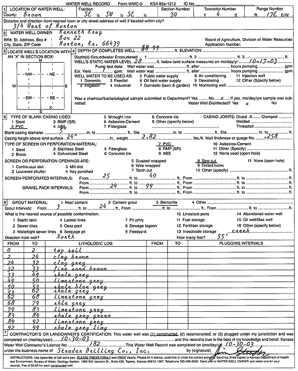
T4S, R17E, Sec. 30 SE SW SE |
Krug, Kenneth | 99 ft. | 28 ft. | 1 gpm. | Domestic | Constructed | 30-Oct-2003 | Scan | |
|
T4S, R17E, Sec. 32 NE NE NE NE |
KDHE | 19.87 ft. | 19.62 ft. | Monitoring well/observation/piezometer | MW 10 | Reconstructed | 10-Jul-2012 | ||
|
T4S, R17E, Sec. 32 NE NE NE NE |
KDHE | 19.97 ft. | Monitoring well/observation/piezometer | MW 10 | Plugged | 16-Nov-2012 | |||
|
T4S, R17E, Sec. 32 SE NW |
Mitchell, Helen | 15 ft. | Domestic | Plugged | 30-Sep-1982 | ||||
|
T4S, R17E, Sec. 32 NE NE |
Roberts, Clair A. | 37 ft. | 8 ft. | Domestic | Plugged | 26-Jul-1982 | |||
|
T4S, R17E, Sec. 33 SE SW SW |
City of Horton | 20 ft. | 6.3 ft. | Monitoring well/observation/piezometer | MW 2 | Constructed | 21-Oct-2014 | ||
|
T4S, R17E, Sec. 33 SE SW SW |
City of Horton | 20 ft. | 6.24 ft. | Monitoring well/observation/piezometer | MW 3 | Constructed | 21-Oct-2014 | ||
|
T4S, R17E, Sec. 33 SE SW SW |
City of Horton | 19.49 ft. | 11.63 ft. | Monitoring well/observation/piezometer | MW 8 | Plugged | 13-Apr-2016 | ||
|
T4S, R17E, Sec. 33 SE SW SW |
City of Horton | 20.04 ft. | 7.88 ft. | Monitoring well/observation/piezometer | MW 2 | Plugged | 13-Apr-2016 | ||
|
T4S, R17E, Sec. 33 SE SW SW |
City of Horton | 20 ft. | 6.07 ft. | Monitoring well/observation/piezometer | MW 1 | Constructed | 21-Oct-2014 | ||
|
T4S, R17E, Sec. 33 SE SW SW |
City of Horton | 20 ft. | 7.72 ft. | Monitoring well/observation/piezometer | MW 5 | Constructed | 21-Oct-2014 | ||
| View page: < Prev || 21 || 22 || 23 | |||||||||