Select location of well to view details.
Click on column heading to sort.
|
|
|
County: Brown Select location of well to view details. Click on column heading to sort. |
|
|
|
| View page: < Prev || 21 || 22 || 23 | |||||||||
| T-R-S | Owner | Well Depth Ascend. Desc. |
Static Water Level Ascend. Desc. |
Est. Yield Ascend. Desc. |
Well Use | Other ID | Action Taken | Completion Date Ascend. Desc. |
Scan? |
|
T4S, R17E, Sec. 33 SE SW SW |
City of Horton | 19.49 ft. | 11.63 ft. | Monitoring well/observation/piezometer | MW 8 | Plugged | 13-Apr-2016 | ||
|
T4S, R17E, Sec. 33 SE SW SW |
City of Horton | 20 ft. | 6.07 ft. | Monitoring well/observation/piezometer | MW 1 | Constructed | 21-Oct-2014 | ||
|
T4S, R17E, Sec. 33 SE SW SW |
City of Horton | 20 ft. | 9.8 ft. | Monitoring well/observation/piezometer | MW 6 | Constructed | 21-Oct-2014 | ||
|
T4S, R17E, Sec. 33 SE SW SW |
City of Horton | 20 ft. | 5.14 ft. | Monitoring well/observation/piezometer | MW 4 | Constructed | 21-Oct-2014 | ||
|
T4S, R17E, Sec. 33 SE SW SW |
City of Horton | 20.04 ft. | 7.88 ft. | Monitoring well/observation/piezometer | MW 2 | Plugged | 13-Apr-2016 | ||
|
T4S, R17E, Sec. 33 SE SW SW |
City of Horton | 19.65 ft. | 10.99 ft. | Monitoring well/observation/piezometer | MW 6 | Plugged | 13-Apr-2016 | ||
|
T4S, R17E, Sec. 33 SE SW SW |
City of Horton | 19.9 ft. | 6.92 ft. | Monitoring well/observation/piezometer | MW 4 | Plugged | 13-Apr-2016 | ||
|
T4S, R17E, Sec. 33 SE SW SW |
City of Horton | 20.02 ft. | 7.67 ft. | Monitoring well/observation/piezometer | MW 3 | Plugged | 13-Apr-2016 | ||
|
T4S, R17E, Sec. 33 SE SW SW |
City of Horton | 19.82 ft. | 7.84 ft. | Monitoring well/observation/piezometer | MW 1 | Plugged | 13-Apr-2016 | ||
|
T4S, R17E, Sec. 33 SE SW SW |
City of Horton | 19.52 ft. | 6.3 ft. | Monitoring well/observation/piezometer | MW 7 | Plugged | 13-Apr-2016 | ||
|
T4S, R17E, Sec. 33 NW NW SW |
Davies Oil Company | 30 ft. | 13.01 ft. | Monitoring well/observation/piezometer | MW 7 | Constructed | 23-Jul-2004 | ||
|
T4S, R17E, Sec. 33 NW NW SW |
Davies Oil Company | 23 ft. | 15.32 ft. | Monitoring well/observation/piezometer | MW 2 | Constructed | 23-Jul-2004 | ||
|
T4S, R17E, Sec. 33 NW NW SW |
Davies Oil Company | 35 ft. | 18.33 ft. | Monitoring well/observation/piezometer | MW 1 | Constructed | 23-Jul-2004 | ||
|
T4S, R17E, Sec. 33 NW NW SW |
Davies Oil Company | 30 ft. | 17.57 ft. | Monitoring well/observation/piezometer | MW 6 | Constructed | 23-Jul-2004 | ||
|
T4S, R17E, Sec. 33 NW NW SW |
Davies Oil Company | 25 ft. | 15.88 ft. | Monitoring well/observation/piezometer | MW 3 | Constructed | 23-Jul-2004 | ||
|
T4S, R17E, Sec. 33 NW NW SW |
Davies Oil Company | 30 ft. | 13 ft. | Monitoring well/observation/piezometer | MW 4 | Constructed | 23-Jul-2004 | ||
|
T4S, R17E, Sec. 33 NW NW SW |
Davies Oil Company | 30 ft. | 17.45 ft. | Monitoring well/observation/piezometer | MW 5 | Constructed | 23-Jul-2004 | ||
|
T4S, R17E, Sec. 33 NW NW SW |
Davies Oil Company/KDHE T and M | 26 ft. | Monitoring well/observation/piezometer | MW 4 | Plugged | 03-Feb-2009 | |||
|
T4S, R17E, Sec. 33 NW NW SW |
Davies Oil Company/KDHE T and M | 24 ft. | Monitoring well/observation/piezometer | MW 1 | Plugged | 03-Feb-2009 | |||
|
T4S, R17E, Sec. 33 NW NW SW |
Davies Oil Company/KDHE T and M | 30 ft. | Monitoring well/observation/piezometer | MW 6 | Plugged | 03-Feb-2009 | |||
|
T4S, R17E, Sec. 33 NW NW SW |
Davies Oil Company/KDHE T and M | 24 ft. | Monitoring well/observation/piezometer | MW 2 | Plugged | 03-Feb-2009 | |||
|
T4S, R17E, Sec. 33 NW NW SW |
Davies Oil Company/KDHE T and M | 29 ft. | Monitoring well/observation/piezometer | MW 5 | Plugged | 03-Feb-2009 | |||
|
T4S, R17E, Sec. 33 NW NW SW |
Davies Oil Company/KDHE T and M | 29 ft. | Monitoring well/observation/piezometer | MW 7 | Plugged | 03-Feb-2009 | |||
|
T4S, R17E, Sec. 33 NW NW SW |
Davies Oil Company/KDHE T and M | 24 ft. | Monitoring well/observation/piezometer | MW 3 | Plugged | 03-Feb-2009 | |||
|
T4S, R17E, Sec. 33 NW NW NW |
KDHE | 20.1 ft. | 5.21 ft. | Monitoring well/observation/piezometer | MW 9 | Reconstructed | 10-Jul-2012 | ||
|
T4S, R17E, Sec. 33 NW NW NW |
KDHE | 20.11 ft. | Monitoring well/observation/piezometer | MW 9 | Plugged | 16-Nov-2012 | |||
|
T4S, R17E, Sec. 33 SW SW SE |
Rokita, John | 49 ft. | 15.67 ft. | 6 gpm. | Domestic, Lawn and Garden | Constructed | 18-Aug-2008 | ||
|
T4S, R18E, Sec. 2 SW NE NW |
Anderson, Oscar H. | 40 ft. | 24 ft. | 5 gpm. | Domestic | Constructed | 06-Oct-1983 | ||
|
T4S, R18E, Sec. 2 SE SE NE |
Geiger, Matt | 100 ft. | 9 ft. | 2 gpm. | Domestic, Livestock | Constructed | 20-Jun-2022 |
KOLAR |
|
|
T4S, R18E, Sec. 2 NW SE SE |
Harrison, Phil | 55 ft. | 22 ft. | 5 gpm. | Domestic | Constructed | 19-Nov-1980 | ||
|
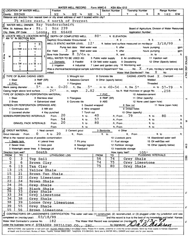
T4S, R18E, Sec. 2 NE NE NE |
Vonderschmidt, Ray | 80 ft. | 12 ft. | 3 gpm. | Domestic | Constructed | 18-Mar-1999 | Scan | |
|
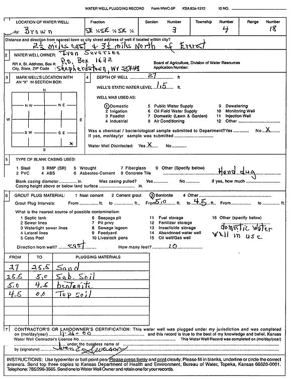
T4S, R18E, Sec. 3 SE SE SE |
Severson, Ivan | 27 ft. | 1.5 ft. | Domestic | Plugged | 26-Nov-2000 | Scan | ||
|
T4S, R18E, Sec. 4 SW NW NW |
Madison, Spencer | 50 ft. | 4 ft. | 20 gpm. | Domestic | Constructed | 28-Jan-1988 | ||
|
T4S, R18E, Sec. 5 SE SE SE |
Mauslein, Don | 78 ft. | 12 ft. | 15 gpm. | Domestic | Constructed | 04-Nov-1982 | ||
|
T4S, R18E, Sec. 6 NE NE NE |
Edwardson, Bill | 58 ft. | 28 ft. | 20 gpm. | Domestic | Constructed | 30-Mar-1984 | ||
|
T4S, R18E, Sec. 9 NE NE NW |
Katz, Joe | 150 ft. | 100 ft. | 40 gpm. | Domestic | Constructed | 24-Nov-1975 | ||
|
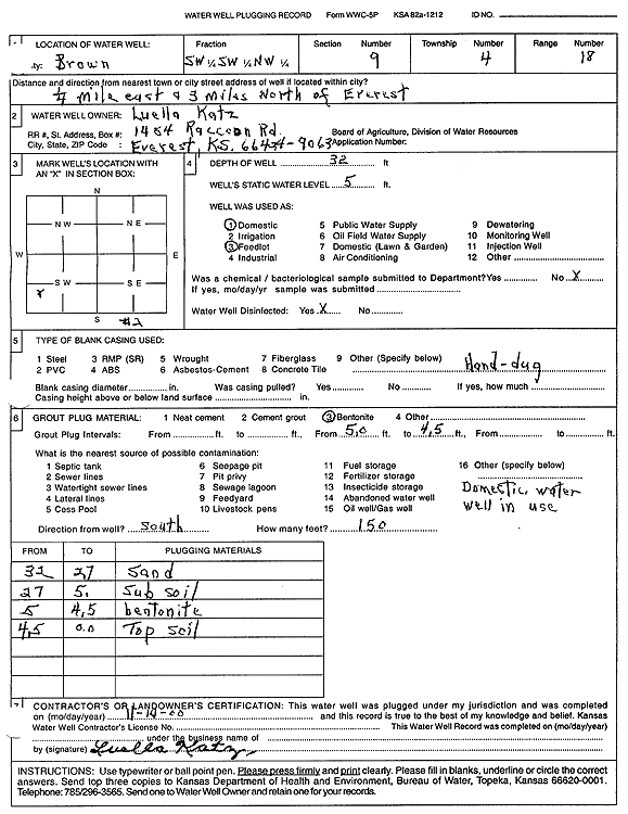
T4S, R18E, Sec. 9 SW SW NW |
Katz, Luella | 32 ft. | 5 ft. | Domestic | Plugged | 14-Nov-2000 | Scan | ||
|
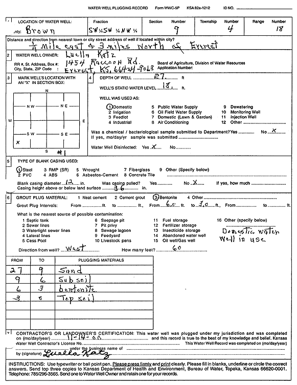
T4S, R18E, Sec. 9 SW SW NW |
Katz, Luella | 27 ft. | 18 ft. | Domestic | Plugged | 14-Nov-2000 | Scan | ||
|
T4S, R18E, Sec. 10 SE NE SE |
Cox, Francis D. | 27 ft. | 11 ft. | Domestic | Plugged | 16-Jul-2005 | |||
|
T4S, R18E, Sec. 10 NW SW NE |
Jamvold, Darrell | 100 ft. | 12 ft. | 3 gpm. | Domestic | Constructed | 14-Mar-1980 | ||
|
T4S, R18E, Sec. 10 SE SE SW |
Walter J. Adams Estate | 16 ft. | 13 ft. | (unstated)/abandoned | Plugged | 16-Oct-2000 | Scan | ||
|
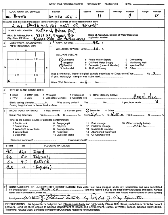
T4S, R18E, Sec. 11 SW SW SW |
Walter J. Adams Estate | 45 ft. | 13 ft. | Domestic | Plugged | 16-Oct-2000 | Scan | ||
|
T4S, R18E, Sec. 12 NE SE NE |
Geiger, Matt | 78 ft. | 13 ft. | 15 gpm. | Domestic | Constructed | 10-Jun-2022 |
KOLAR |
|
|
T4S, R18E, Sec. 13 SE SE NE |
Smith, Joseph R. | 87 ft. | 38 ft. | 4 gpm. | Domestic | Constructed | 04-Mar-1990 | ||
|
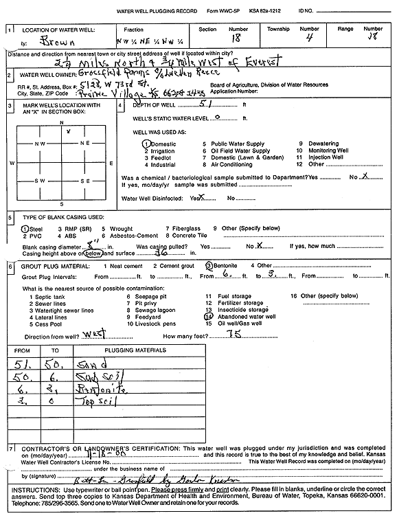
T4S, R18E, Sec. 18 NW NE NW |
Grossfield Farms | 51 ft. | Domestic | Plugged | 18-Nov-2000 | Scan | |||
|
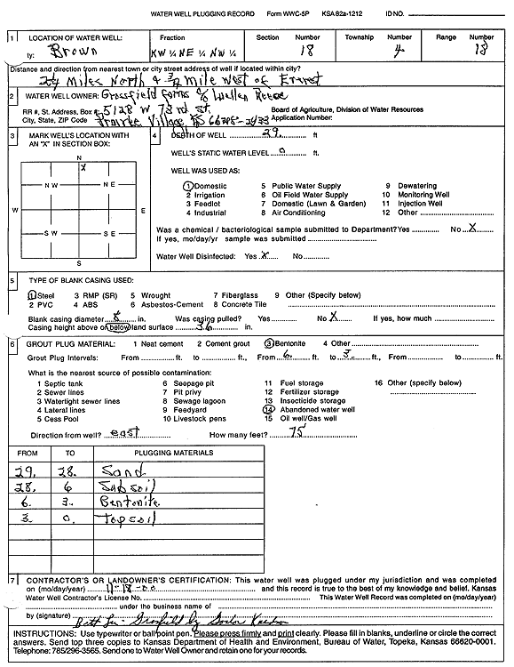
T4S, R18E, Sec. 18 NW NE NW |
Grossfield Farms | 29 ft. | Domestic | Plugged | 18-Nov-2000 | Scan | |||
|
T4S, R18E, Sec. 19 SW SW SE |
U. S. Dept of Agriculture | 42 ft. | 30.06 ft. | Monitoring well/observation/piezometer | SB 72 | Constructed | 15-Nov-2003 | ||
|
T4S, R18E, Sec. 19 SW SW SE |
U. S. Dept of Agriculture | 55 ft. | 42.03 ft. | Monitoring well/observation/piezometer | SB 77 | Constructed | 20-Nov-2003 | ||
|
T4S, R18E, Sec. 21 NW NW |
Guillickson, Weldon | 82 ft. | 26 ft. | 4 gpm. | Domestic | Constructed | 12-Nov-1982 | ||
|
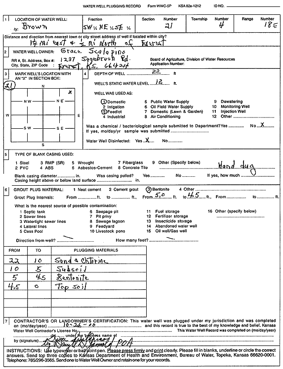
T4S, R18E, Sec. 21 SW NE SE |
Scalopino, Grace | 22 ft. | 12 ft. | Domestic, Livestock | Plugged | 26-Oct-2000 | Scan | ||
| View page: < Prev || 21 || 22 || 23 | |||||||||