Select location of well to view details.
Click on column heading to sort.
|
|
|
County: Norton Select location of well to view details. Click on column heading to sort. |
|
|
|
| View page: 1 || 2 || 3 || 4 || 5 || 6 || 7 || 8 || 9 || 10 || Next > | |||||||||
| T-R-S | Owner | Well Depth Ascend. Desc. |
Static Water Level Ascend. Desc. |
Est. Yield Ascend. Desc. |
Well Use | Other ID | Action Taken | Completion Date Ascend. Desc. |
Scan? |
|
T2S, R22W, Sec. 4 NW SE |
Nelson Farms Inc. | 77 ft. | 61 ft. | Irrigation | Constructed | 30-Mar-2012 | |||
|
T2S, R22W, Sec. 5 NW NW NW |
Wegener, Don | 110 ft. | 79 ft. | Domestic | Constructed | 24-Apr-1996 | |||
|
T2S, R22W, Sec. 7 SE SW SW |
McMullen, Don | 72 ft. | 47 ft. | Domestic | Constructed | 22-Dec-2010 | |||
|
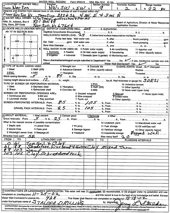
T2S, R22W, Sec. 9 NW SW SW |
Whitney Construction and Farms | 105 ft. | 24 ft. | Domestic | Constructed | 25-Nov-2002 | Scan | ||
|
T2S, R22W, Sec. 11 SW SE SW |
Poage, Darnell | 93 ft. | 59 ft. | Domestic | Constructed | 11-Dec-1996 | |||
|
T2S, R22W, Sec. 13 SE SE SE |
Fritz, Harry | 64 ft. | 29 ft. | 20 gpm. | Domestic | Constructed | 05-Nov-1979 | ||
|
T2S, R22W, Sec. 13 SW NE NE |
Hardy, Lee | 87 ft. | 72 ft. | Domestic | Constructed | 19-Apr-1995 | |||
|
T2S, R22W, Sec. 13 SE NW NE SW |
Nelson Farms Inc. | 27 ft. | 21 ft. | 3 gpm. | Domestic | Constructed | 27-Oct-2021 |
KOLAR |
|
|
T2S, R22W, Sec. 14 SE NW NE |
Burd, John | 104 ft. | 67.3 ft. | Domestic | Constructed | 09-Oct-1991 | |||
|
T2S, R22W, Sec. 15 SE SW |
Wyrill, John | 86 ft. | 57 ft. | 30 gpm. | Domestic | Constructed | 17-Mar-1976 | ||
|
T2S, R22W, Sec. 18 NW NE NW |
Ambroiser, Darrell | 58 ft. | 41 ft. | Domestic | Constructed | 20-Sep-1993 | |||
|
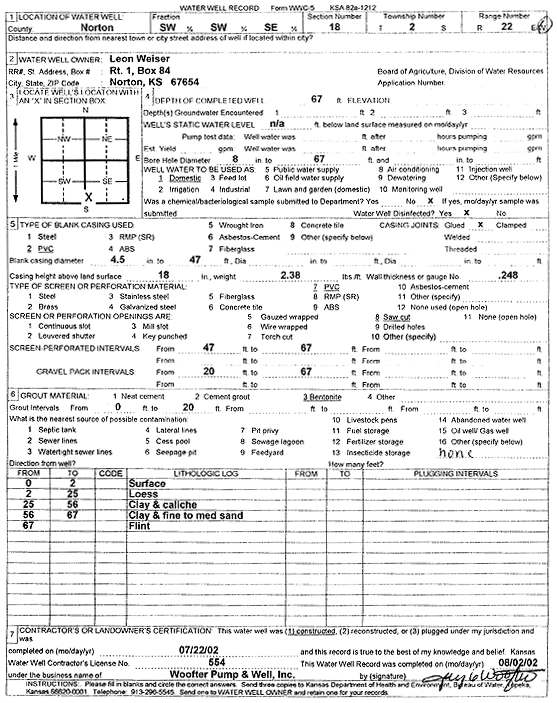
T2S, R22W, Sec. 18 SW SW SE |
Weiser, Leon | 67 ft. | Domestic | Constructed | 22-Jul-2002 | Scan | |||
|
T2S, R22W, Sec. 20 SE SE NE |
Devall, Millard | 68 ft. | 47 ft. | 15 gpm. | Domestic, Lawn and Garden | Constructed | 02-Aug-1979 | ||
|
T2S, R22W, Sec. 20 SW NW NW |
Whitney Construction and Farms | 65 ft. | 39 ft. | 19 gpm. | Domestic | Constructed | 02-Dec-2016 | ||
|
T2S, R22W, Sec. 21 SE SE SW |
Whitney, Naedean | 84 ft. | 68 ft. | 18 gpm. | Domestic, Livestock | Constructed | 02-Dec-2016 | ||
|
T2S, R22W, Sec. 22 NW NW SW SW |
Nelson Farms Inc. | 80 ft. | 49 ft. | 40 gpm. | Domestic, Livestock | Constructed | 21-Oct-2018 |
KOLAR |
|
|
T2S, R22W, Sec. 24 NW NE SW |
Field, Dan | 55 ft. | 36 ft. | Domestic | Constructed | 23-Mar-1993 | |||
|
T2S, R22W, Sec. 24 SW SW SW |
Field, Julius | 50 ft. | 37 ft. | Domestic | Constructed | 01-Jun-1984 | |||
|
T2S, R22W, Sec. 24 SW SE NW |
Van Patten, Tony | 53 ft. | 31 ft. | Domestic | Constructed | 04-Jan-1989 | |||
|
T2S, R22W, Sec. 25 SW SW NW |
Bieber, John | 72 ft. | 36.5 ft. | Domestic | Constructed | 22-Jun-1983 | |||
|
T2S, R22W, Sec. 25 NW NW SW |
Bieber, Rita | 80 ft. | 44 ft. | Domestic | Constructed | 11-Dec-1995 | |||
|
T2S, R22W, Sec. 25 SW SW NW |
Calvert Station | 38.5 ft. | 31.22 ft. | Monitoring well/observation/piezometer | MW 12A | Constructed | 18-Apr-1996 | ||
|
T2S, R22W, Sec. 25 SW SW NW |
Calvert Station | 37 ft. | 29.04 ft. | Monitoring well/observation/piezometer | MW 12 | Constructed | 20-Feb-1996 | ||
|
T2S, R22W, Sec. 25 SW SW NW |
Calvert Station | 37 ft. | 29.04 ft. | Monitoring well/observation/piezometer | MW 12 | Plugged | 08-Apr-1996 | ||
|
T2S, R22W, Sec. 25 SW SW NW |
Devall, Millard | 50 ft. | 37.64 ft. | Monitoring well/observation/piezometer | MW 5 | Constructed | 18-Nov-1994 | ||
|
T2S, R22W, Sec. 25 SW SW NW |
Devall, Millard | 50 ft. | 33.02 ft. | Monitoring well/observation/piezometer | MW 4 | Constructed | 17-Nov-1994 | ||
|
T2S, R22W, Sec. 25 NW SW SW NW |
Duvall, Millard | 46 ft. | 33.23 ft. | Monitoring well/observation/piezometer | MW 4 | Plugged | 13-Jun-2022 | ||
|
T2S, R22W, Sec. 25 NW SW SW NW |
KDHE | 46 ft. | Monitoring well/observation/piezometer | MW 16 | Constructed | 06-Jul-2022 | |||
|
T2S, R22W, Sec. 25 SW SW NW |
KDHE - T and M | 63 ft. | 52 ft. | 2 gpm. | Monitoring well/observation/piezometer | MW-14 | Constructed | 20-Feb-2008 | |
|
T2S, R22W, Sec. 25 NE NE NE SW |
Kendall, Kim | 62 ft. | 20 ft. | Domestic | Plugged | 29-Apr-2016 | |||
|
T2S, R22W, Sec. 25 NE NE SW |
Zerr, Mike | 80 ft. | 42 ft. | Domestic | Constructed | 10-Dec-1991 | |||
|
T2S, R22W, Sec. 26 SE SE NE |
Calvert Station | 60 ft. | 47.15 ft. | Monitoring well/observation/piezometer | MW 13 | Constructed | 21-Feb-1996 | ||
|
T2S, R22W, Sec. 26 SE SE NE |
Calvert Station | 43 ft. | 34.68 ft. | Monitoring well/observation/piezometer | MW 10 | Constructed | 19-Feb-1996 | ||
|
T2S, R22W, Sec. 26 SE SE SE NE |
Calvert Station | 48.95 ft. | 41.12 ft. | Monitoring well/observation/piezometer | MW 11 | Plugged | 13-Jun-2022 | ||
|
T2S, R22W, Sec. 26 NE SE SE NE |
Calvert Station | 43.2 ft. | 36.03 ft. | Monitoring well/observation/piezometer | MW 10 | Plugged | 13-Jun-2022 | ||
|
T2S, R22W, Sec. 26 SE SE NE |
Calvert Station | 49.5 ft. | 39.83 ft. | Monitoring well/observation/piezometer | MW 11 | Constructed | 19-Feb-1996 | ||
|
T2S, R22W, Sec. 26 SE SE NE |
Devall, Millard | 45 ft. | 33.47 ft. | Monitoring well/observation/piezometer | MW 6 | Constructed | 19-Nov-1994 | ||
|
T2S, R22W, Sec. 26 SE SE SE NE |
Devall, Millard | 47.4 ft. | 37.72 ft. | Monitoring well/observation/piezometer | MW 2 | Plugged | 13-Jun-2022 | ||
|
T2S, R22W, Sec. 26 NE SE SE NE |
Devall, Millard | 40.8 ft. | 34.4 ft. | Monitoring well/observation/piezometer | MW 6 | Plugged | 13-Jun-2022 | ||
|
T2S, R22W, Sec. 26 SE SE NE |
Devall, Millard | 50 ft. | 36.57 ft. | Monitoring well/observation/piezometer | MW 9 | Constructed | 22-Nov-1994 | ||
|
T2S, R22W, Sec. 26 SE SE NE |
Devall, Millard | 45 ft. | 32.16 ft. | Monitoring well/observation/piezometer | MW 8 | Constructed | 21-Nov-1994 | ||
|
T2S, R22W, Sec. 26 SE SE NE |
Devall, Millard | 50 ft. | 37.26 ft. | Monitoring well/observation/piezometer | MW 1 | Constructed | 16-Nov-1994 | ||
|
T2S, R22W, Sec. 26 SE SE NE |
Devall, Millard | 50 ft. | 41.52 ft. | Monitoring well/observation/piezometer | MW 3 | Constructed | 17-Nov-1994 | ||
|
T2S, R22W, Sec. 26 SE SE NE |
Devall, Millard | 50 ft. | 36.73 ft. | Monitoring well/observation/piezometer | MW 2 | Constructed | 17-Nov-1994 | ||
|
T2S, R22W, Sec. 26 SE SE NE |
Devall, Millard | 52 ft. | 43.22 ft. | Monitoring well/observation/piezometer | MW 7 | Constructed | 19-Nov-1994 | ||
|
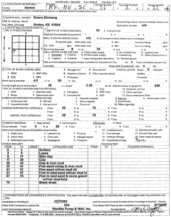
T2S, R22W, Sec. 26 NW NW SE |
Dizmang, Duane | 70 ft. | Domestic | Constructed | 03-Jul-2002 | Scan | |||
|
T2S, R22W, Sec. 26 NE SE SE NE |
KDHE | 41 ft. | Monitoring well/observation/piezometer | MW 17 | Constructed | 06-Jul-2022 | |||
|
T2S, R22W, Sec. 26 SE SE NE |
KDHE | 50.6 ft. | Monitoring well/observation/piezometer | MW 7 | Plugged | 10-May-2011 | |||
|
T2S, R22W, Sec. 26 SE SE SE NE |
KDHE | 47 ft. | Monitoring well/observation/piezometer | MW 15 | Constructed | 05-Jul-2022 | |||
|
T2S, R22W, Sec. 26 NE SE SE NE |
KDHE | 43 ft. | Monitoring well/observation/piezometer | MW 18 | Constructed | 06-Jul-2022 | |||
| View page: 1 || 2 || 3 || 4 || 5 || 6 || 7 || 8 || 9 || 10 || Next > | |||||||||